Ambalavao
Ambalavao | |
|---|---|
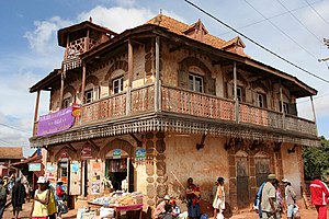 The town centre of Ambalavao as of November 2007 | |
 Coat of arms | |
 Ambalavao Location in Madagascar | |
| Coordinates: 21°50′S 46°56′E / 21.833°S 46.933°E | |
| Country | |
| Province | Haute Matsiatra |
| Population (2001)[1] | |
| • Total | 30,000 |
| • Ethnicities | Betsileo |
| Postal code | 303 |
| Climate | Cwa |

Ambalavao [amˌbalaˈvaw] is a city (commune urbaine) in Madagascar, in the Haute Matsiatra region. The city is in the most southern part of the Central Highlands, near the city of Fianarantsoa.
Nature[]
- The Anja Community Reserve, situated about 13 km south of Ambalavao, is a small community-based reserve created to preserve and manage local natural resources.
- Andringitra National Park is located near this city.
Geography[]
Ambalavao is situated at the Route Nationale No. 7 Fianarantsoa-Ihosy-Tuléar at 160 km from Ihosy and 56 km from Fianarantsoa.[2] An serves the town.
Climate[]
Ambalavao has a humid subtropical climate (Köppen: Cwa).
| Climate data for Ambalavao | |||||||||||||
|---|---|---|---|---|---|---|---|---|---|---|---|---|---|
| Month | Jan | Feb | Mar | Apr | May | Jun | Jul | Aug | Sep | Oct | Nov | Dec | Year |
| Daily mean °C (°F) | 22.1 (71.8) |
21.9 (71.4) |
21.4 (70.5) |
20.3 (68.5) |
18.1 (64.6) |
16.0 (60.8) |
15.1 (59.2) |
15.9 (60.6) |
17.8 (64.0) |
20.2 (68.4) |
21.6 (70.9) |
22.0 (71.6) |
19.4 (66.9) |
| Average precipitation mm (inches) | 260 (10.2) |
169 (6.7) |
153 (6.0) |
27 (1.1) |
16 (0.6) |
18 (0.7) |
14 (0.6) |
15 (0.6) |
19 (0.7) |
34 (1.3) |
112 (4.4) |
234 (9.2) |
1,071 (42.1) |
| Source: Climate-Data.org[3] | |||||||||||||
Transports[]
The city is served by .
See also[]
Coordinates: 21°50′S 46°56′E / 21.833°S 46.933°E
Gallery[]
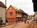
Ambalavao main street

Ambalavao main street


References[]
| Wikivoyage has a travel guide for Ambalavao. |
- ^ The Commune Census of by the Ilo program of Cornell University in collaboration with FOFIFA and INSTAT
- ^ Atlas Mondial, France Loisir, page 159
- ^ "Climate:Ambalavao". Climate-Data.org. Retrieved 11 April 2014.
Capital: Fianarantsoa | ||
| Ambalavao (17) - 303 |  | |
| Ambohimahasoa (17) - 305 | ||
| Fianarantsoa (1) - 301 | ||
| Ikalamavony (8) - 314 | ||
| Isandra (13) - 314 | ||
| Lalangina (13) - 303 | ||
| Vohibato (15) - 305 | ||
Total: 7 districts; 84 communes | ||
This Haute Matsiatra location article is a stub. You can help Wikipedia by . |
Categories:
- Cities in Madagascar
- Populated places in Haute Matsiatra
- Haute Matsiatra geography stubs