Fianarantsoa
Fianarantsoa | |
|---|---|
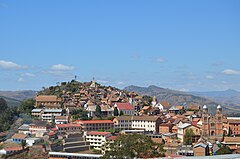 Upper town Fianarantsoa | |
 Coat of arms | |
 Fianarantsoa Location of Fianarantsoa in Madagascar | |
| Coordinates: 21°27′13″S 047°05′09″E / 21.45361°S 47.08583°ECoordinates: 21°27′13″S 047°05′09″E / 21.45361°S 47.08583°E | |
| Country | |
| Province | Fianarantsoa |
| Region | Haute Matsiatra |
| District | |
| Founded | 1830 |
| Area | |
| • Total | 86.05 km2 (33.22 sq mi) |
| Elevation | 1,200 m (3,900 ft) |
| Population (2018) | |
| • Total | 191,776 |
| • Density | 2,200/km2 (5,800/sq mi) |
| [1] | |
| Time zone | East African Time (GMT+3) |
| Postal code | 301 |
| Climate | Cwb |

Fianarantsoa is a city (commune urbaine) in south central Madagascar, and is the capital of Haute Matsiatra Region.
History[]
It was built in the early 19th century by the Merina as the administrative capital for the newly conquered Betsileo kingdoms.
Fianarantsoa means "Good education" in Malagasy. It is a cultural and intellectual center for the whole island. It is home to some of the oldest Protestant and Lutheran cathedrals on the island, the oldest theological seminary (also Lutheran), as well as the Roman Catholic Archdiocese of Fianarantsoa (seated in the Cathedral of the Holy Name of Jesus). The city of "good education" also boasts a university named after it and built in 1972. Fianarantsoa is considered to be the capital of wine in Madagascar, because of the presence of many wine industries in the city.
Geography[]
It is at an average altitude of 1,200 metres (3,900 ft), and has a population of 191,766.
The town is linked to the rest of the country by the National road 7, one of the main highways in Madagascar. The distance is 411 km to the capital Antananarivo, 192 km to Ihosy, 518 km to Tulear.
At 65 km is found the Ranomafana National Park.
Transport[]
The city is at the endpoint of the Fianarantsoa-Côte Est Railway to Manakara. There is also an airport.
Climate[]
Köppen-Geiger climate classification system classifies its climate as subtropical highland (Cwb).[2]
| hideClimate data for Fianarantsoa | |||||||||||||
|---|---|---|---|---|---|---|---|---|---|---|---|---|---|
| Month | Jan | Feb | Mar | Apr | May | Jun | Jul | Aug | Sep | Oct | Nov | Dec | Year |
| Average high °C (°F) | 26.2 (79.2) |
26.1 (79.0) |
25.3 (77.5) |
24.5 (76.1) |
22.6 (72.7) |
20.4 (68.7) |
19.7 (67.5) |
20.4 (68.7) |
23.0 (73.4) |
25.0 (77.0) |
26.1 (79.0) |
26.3 (79.3) |
23.8 (74.8) |
| Daily mean °C (°F) | 20.8 (69.4) |
20.8 (69.4) |
20.0 (68.0) |
18.9 (66.0) |
16.7 (62.1) |
14.5 (58.1) |
14.0 (57.2) |
14.4 (57.9) |
16.2 (61.2) |
18.3 (64.9) |
19.7 (67.5) |
20.4 (68.7) |
17.9 (64.2) |
| Average low °C (°F) | 17.2 (63.0) |
17.2 (63.0) |
16.5 (61.7) |
15.2 (59.4) |
12.7 (54.9) |
10.5 (50.9) |
10.1 (50.2) |
10.2 (50.4) |
11.2 (52.2) |
13.4 (56.1) |
15.3 (59.5) |
16.6 (61.9) |
13.8 (56.8) |
| Average precipitation mm (inches) | 227.8 (8.97) |
220.8 (8.69) |
137.6 (5.42) |
46.4 (1.83) |
27.3 (1.07) |
16.5 (0.65) |
24.6 (0.97) |
21.4 (0.84) |
18.0 (0.71) |
61.5 (2.42) |
124.9 (4.92) |
241.4 (9.50) |
1,168.2 (45.99) |
| Average precipitation days (≥ 1.0 mm) | 15 | 14 | 13 | 7 | 5 | 5 | 6 | 6 | 3 | 6 | 11 | 16 | 107 |
| Mean monthly sunshine hours | 191.1 | 171.0 | 175.4 | 184.8 | 186.0 | 165.9 | 163.5 | 191.1 | 220.5 | 230.4 | 208.0 | 190.1 | 2,277.8 |
| Source: NOAA[3] | |||||||||||||
Education[]

- Université de Fianarantsoa
French international schools:
Personalities[]
- Odon Razanakolona (born 1946), archbishop
- Pety Rakotoniaina (born 1962), politician
See also[]
References[]
- ^ TROISIEME RECENSEMENT GENERAL DE LA POPULATION ET DE L’HABITATION
- ^ "Climate: Fianarantsoa - Climate graph, Temperature graph, Climate table". Climate-Data.org. Retrieved 2014-02-01.
- ^ "Fianarantsoa Climate Normals 1961–1990". National Oceanic and Atmospheric Administration. Retrieved March 8, 2015.
- ^ "Collège français René-Cassin." AEFE. Retrieved on May 7, 2015.
- ^ Home page (Archive). Collège français René-Cassin. Retrieved on May 7, 2015.
External links[]
| Wikimedia Commons has media related to Fianarantsoa. |
![]() Fianarantsoa travel guide from Wikivoyage
Fianarantsoa travel guide from Wikivoyage

| show Authority control |
|---|
- Fianarantsoa
- Cities in Madagascar
- Populated places in Haute Matsiatra
- Regional capitals in Madagascar