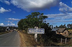
Amparafaravola
Amparafaravola | |
|---|---|
 Amparafaravola | |
 Amparafaravola Location in Madagascar | |
| Coordinates: 17°35′S 48°13′E / 17.583°S 48.217°E | |
| Country | |
| Region | Alaotra-Mangoro |
| District | Amparafaravola |
| Elevation | 792 m (2,598 ft) |
| Population (2018)[2] | |
| • Total | 33,299 |
| Time zone | UTC3 (EAT) |
| Postal code | 504 |

Amparafaravola is a town and commune (Malagasy: kaominina) in Madagascar. It belongs to the district of Amparafaravola, which is a part of Alaotra-Mangoro Region. The population of the commune was 33,299 in 2018.
In addition to primary schooling, the town offers secondary education at both junior and senior levels. The town provides access to hospital services for its citizens. Over 80% of the population of the commune are farmers and 10% receive their livelihood from raising livestock. The most important crop is rice. Other important agricultural products include maize and cassava. Industry and services provide employment for 1% and 8% of the population, respectively. Additionally, fishing employs 1% of the population.[3] An serves the town.
References and notes[]
- ^ Estimated based on DEM data from Shuttle Radar Topography Mission
- ^ TROISIEME RECENSEMENT GENERAL DE LA POPULATION ET DE L’HABITATION
- ^ "ILO census data". Cornell University. 2002. Retrieved 2008-03-24.
Capital: Ambatondrazaka | ||
| Ambatondrazaka (20) |  | |
| Amparafaravola (21) | ||
| Andilamena (8) | ||
| Anosibe An'ala (11) | ||
| Moramanga (22) | ||
5 districts; 82 communes | ||
Coordinates: 17°35′S 48°13′E / 17.583°S 48.217°E
This Alaotra-Mangoro location article is a stub. You can help Wikipedia by . |
- Cities in Madagascar
- Populated places in Alaotra-Mangoro
- Alaotra-Mangoro geography stubs