Didy
Didy | |
|---|---|
 Didy | |
 Didy Location in Madagascar | |
| Coordinates: 18°7′S 48°32′E / 18.117°S 48.533°E | |
| Country | |
| Region | Alaotra-Mangoro |
| District | Ambatondrazaka |
| Government | |
| • Mayor | |
| Area | |
| • Total | 1,773.16 km2 (684.62 sq mi) |
| Elevation | 1,034 m (3,392 ft) |
| Population (2018)[2] | |
| • Total | 33,039 |
| Time zone | UTC3 (EAT) |
| Postal code | 503 |

Didy is a rural commune in Madagascar. It belongs to the district of Ambatondrazaka, which is a part of Alaotra-Mangoro Region. The population of the commune was estimated to be 33,039 in 2018.
The town of Didy is situated at 54 km from Ambatondrazaka.[1]
Only primary schooling is available. The majority 85% of the population of the commune are farmers, while an additional 14% receives their livelihood from raising livestock. The most important crop is rice, while other important products are maize, cassava and tomato. Services provide employment for 1% of the population.[4]
History[]
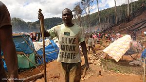
In the beginning of 2012, a sapphire and ruby rush occurred 25 kilometers south-east of Didy. The rush was due to the exceptional color, clarity and size of the precious stones found there.
Discovered in alluvium, in the core of a wild forest located in the Ankeniheny-Zahamena national park, sapphires and rubies required holes from 50 centimeters to 2 meters depth to be extracted.
Following the arrival of 40,000 people on the occurrence, the government evacuated the area in June 2012 and the access was denied.
References and notes[]
- ^ Jump up to: a b (in French) www.newsmada.com/
- ^ TROISIEME RECENSEMENT GENERAL DE LA POPULATION ET DE L’HABITATION
- ^ Estimated based on DEM data from Shuttle Radar Topography Mission
- ^ "ILO census data". Cornell University. 2002. Retrieved 2008-03-06.
External links[]
| hide | ||
|---|---|---|
Capital: Ambatondrazaka | ||
| Ambatondrazaka (20) |  | |
| Amparafaravola (21) | ||
| Andilamena (8) | ||
| Anosibe An'ala (11) | ||
| Moramanga (22) | ||
5 districts; 82 communes | ||
| Authority control |
|
|---|
- Populated places in Alaotra-Mangoro
- Sapphire mines in Madagascar
- Ruby mines in Madagascar