Amsterdam–Rhine Canal
This article does not cite any sources. (December 2009) |
| Amsterdam–Rhine Canal | |
|---|---|
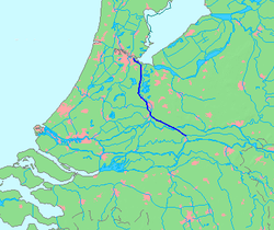 Map of the Amsterdam–Rhine Canal | |
| Specifications | |
| Length | 72 km (45 mi) |
| History | |
| Date completed | 1952 |
| Geography | |
| Start point | Amsterdam, Netherlands |
| End point | Waal river near Tiel, Netherlands |
The Amsterdam–Rhine Canal (Dutch: Amsterdam-Rijnkanaal) is a canal in the Netherlands that was built to connect the port and capital city of Amsterdam to the main shipping artery of the Rhine. Its course follows a generally southeasterly direction as it goes through the city of Utrecht towards Wijk bij Duurstede where it intersects the Lek branch of the Rhine and then continues on to the river Waal near Tiel, with a branch, the Lek Canal, to the Lek near Nieuwegein.
Bridges[]
| Wikimedia Commons has media related to Amsterdam-Rhine Canal. |
Rail bridges (with nearest train station on the west and east bank):
- between Diemen/Diemen-Zuid and Weesp
- Demkaspoorbrug, between Maarssen and Utrecht Centraal
- Vleutensespoorbrug, between Utrecht Leidsche Rijn and Utrecht Centraal
- between Culemborg and Houten
- between Tiel and Kesteren

Utrecht, the Demkaspoorbrug across the canal

Utrecht, the Meernbrug across the canal
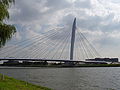
Utrecht, the Prins Clausbrug across the canal

The canal near Rijswijk, Gelderland

The canal near Tiel


Categories:
- Canals in the Netherlands
- Canals opened in 1952
- Canals in the Rhine–Meuse–Scheldt delta
- Canals in North Holland
- Canals in Utrecht (province)
- Canals in Amsterdam
- Buildings and structures in Utrecht (city)
- Transport in Utrecht (city)
- Wijk bij Duurstede