Tholen
Tholen | |
|---|---|
Municipality | |
 Harbour of Tholen | |
 Flag  Coat of arms | |
 Location in Zeeland | |
| Coordinates: 51°32′N 4°12′E / 51.533°N 4.200°ECoordinates: 51°32′N 4°12′E / 51.533°N 4.200°E | |
| Country | Netherlands |
| Province | Zeeland |
| Government | |
| • Body | Municipal council |
| • Mayor | (VVD) |
| Area | |
| • Total | 254.00 km2 (98.07 sq mi) |
| • Land | 146.71 km2 (56.65 sq mi) |
| • Water | 107.29 km2 (41.42 sq mi) |
| Elevation | −1 m (−3 ft) |
| Population (January 2019)[4] | |
| • Total | 25,780 |
| • Density | 176/km2 (460/sq mi) |
| Demonym(s) | Tholenaar |
| Time zone | UTC+1 (CET) |
| • Summer (DST) | UTC+2 (CEST) |
| Postcode | 4675, 4690–4699 |
| Area code | 0166, 0167 |
| Website | www |

Tholen (Dutch pronunciation: [ˈtoːlə(n)] (![]() listen)) is a 25,000 people municipality in the southwest of the Netherlands. The municipality of Tholen takes its name from the town of Tholen, which is the largest population center in the municipality.
listen)) is a 25,000 people municipality in the southwest of the Netherlands. The municipality of Tholen takes its name from the town of Tholen, which is the largest population center in the municipality.
The municipality consists of two peninsulas, formerly islands, the larger one on the south also called Tholen, the smaller one on the north called Sint Philipsland. The two are separated by the former strait, now bay, of . The municipality is bordered on the east by the Eendracht, once a Scheldt branch but now part of the Scheldt-Rhine Canal, crossed by three road bridges, by the Oosterschelde estuary to the south, the straits of - to the west and the Krammer strait to the north.
The town has a small historical center partly surrounded by a "gracht" and partly bordered by a harbour for fishing boats and yachts.
Population centers[]

On the island Sint Philipsland there are three villages:
- Sint Philipsland
- Anna Jacobapolder
- Sluis
On the island Tholen there are seven population centers:
- Oud-Vossemeer
- Poortvliet
- Scherpenisse
- Sint-Annaland
- Sint-Maartensdijk
- Stavenisse
- Tholen
Twin town[]
Tholen is twinned with:
Notable people[]
- Ghiselin Danckerts (ca.1510 in Tholen – 1567) a Dutch composer, singer and music theorist
- Sir Cornelius Vermuyden 1595 in Sint-Maartensdijk – 1677) a Dutch engineer who introduced Dutch land reclamation methods to England
- Chris Lanooy (1881 in Sint-Annaland - 1948) a Dutch potter, designer, ceramist, painter, draftsman and sculptor, and he produced stained-glass art
- Leen Quist (1942 in Sint Philipsland – 2014) a Dutch ceramist, liked a perfect finish and geometric (blue) lines
- Elly Plooij-van Gorsel (born 1947 in Tholen) a Member of the European Parliament
Sport[]
- Keetie van Oosten-Hage (born 1949 in Sint-Maartensdijk) a Dutch former cyclist
- Deborah Gravenstijn (born 1974 in Tholen) a Dutch judoka and Captain in the Royal Netherlands Air Force; bronze medallist at the 2004 Summer Olympics and silver medallist 2008 Summer Olympics
Images[]
Reformed Congregation Tholen
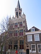
Former city hall

Mill "de Hoop"

Great Church

Venkelstreet

Harbour
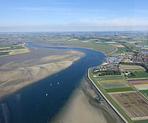
Aerial view of Krabbenkreek


References[]
- ^ "College van B&W" [Board of mayor and aldermen] (in Dutch). Gemeente Tholen. Retrieved 17 December 2013.
- ^ "Kerncijfers wijken en buurten 2020" [Key figures for neighbourhoods 2020]. StatLine (in Dutch). CBS. 24 July 2020. Retrieved 19 September 2020.
- ^ "Postcodetool for 4691DZ". Actueel Hoogtebestand Nederland (in Dutch). Het Waterschapshuis. Retrieved 17 December 2013.
- ^ "Bevolkingsontwikkeling; regio per maand" [Population growth; regions per month]. CBS Statline (in Dutch). CBS. 1 January 2019. Retrieved 1 January 2019.
External links[]
| Wikivoyage has a travel guide for Tholen. |
 Media related to Tholen at Wikimedia Commons
- Official website
| show Places adjacent to Tholen |
|---|

| show Authority control |
|---|
This article about a location in Zeeland is a stub. You can help Wikipedia by . |
- Tholen
- Municipalities of Zeeland
- Populated places in Zeeland
- Landforms of Zeeland
- Rhine–Meuse–Scheldt delta
- Zeeland geography stubs