Anón
Anón | |
|---|---|
 Street scene at road PR-143 East and the northern terminus of PR-139 in Barrio Anon, Ponce, PR | |
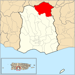 Location of barrio Anón within the municipality of Ponce shown in red | |
 Anón Location of Puerto Rico | |
| Coordinates: 18°08′35″N 66°35′26″W / 18.142917°N 66.590665°WCoordinates: 18°08′35″N 66°35′26″W / 18.142917°N 66.590665°W[1] | |
| Commonwealth | |
| Municipality | |
| Area | |
| • Total | 12.85 sq mi (33.3 km2) |
| • Land | 12.85 sq mi (33.3 km2) |
| • Water | 0 sq mi (0 km2) |
| Elevation | 1,611 ft (491 m) |
| Population (2010) | |
| • Total | 1,670 |
| • Density | 130/sq mi (50/km2) |
| Source: 2010 Census | |
| Time zone | UTC−4 (AST) |

Anón (Barrio Anón) is one of the 31 barrios in the municipality of Ponce, Puerto Rico. Along with Marueño, Coto Laurel, Guaraguao, Quebrada Limon, Real, and San Patricio, and the coastal barrios of Canas and Capitanejo, Anón is one of the municipality's nine bordering barrios. Anón borders the municipalities of Jayuya and Juana Diaz. The name of this barrio is of native Indian origin.[4] It was founded in 1878.[5] Barrio Anón is one of three Ponce barrios (the others are Barrio Guaraguao and Barrio San Patricio) located on the Cordillera Central mountain range.[6]
Location[]
Anón is a mountainous rural barrio located in the northern section of the municipality, north of the city of Ponce.[7] Anon is located within the Cordillera Central and it is home to the highest peak elevation in Puerto Rico called Cerro de Punta. The toponomy, or origin of the name, is related to the fruit tree that belongs to the family Annonaceae.[8]

Boundaries[]
Anón is bounded on the North by PR-143 (Ruta Panorámica), on the South by the hills north of La Compuesta street and Las Mesas Road, on the West by Santo Domingo Hill, El Guayabo Road, Río Cerrillos, Río San Patricio, Cerrillo Road, and Tres Palos-Ramal 1 Road, and on the East by the hills west of PR-123.[9][10]

In terms of barrio-to-barrio boundaries, Anón is bounded in the North by Barrios Jauca, Zamas, Veguitas, and Saliente of the municipality of Jayuya, in the South by Maragüez and Real, in the West by San Patricio, and in the East by Barrio Collores of the municipality of Juana Díaz.[11][12] Among all 31 barrios of Ponce, Anon has the distinction of bordering the most barrios of another municipality, namely, the four barrios of the municipality of Jayuya, or five barrios when Collores (municipality of Juana Díaz) is included.
Demographics[]
Anón is home to the communities of Jurutungo, Los Chinos, Vista Alegre, Raices, and Hogares Seguros.[13]
In 2000, the population of Anón was 1,669 persons, and it had a density of 130 persons per square mile.[14][15][16] In 2010, the population of Anón was 1670, and it had a density of 130 persons per square mile.[17] Anón is the largest barrio in the municipality of Ponce by land area after Canas,[18] but it is the third least populated, after San Patricio and Tibes.
Infrastructure[]
Major roads serving Barrio Anón are PR-143, PR-139, PR-511, and .[19]
Geography[]
Anón has 12.85 square miles (33.3 km2) of land area and no water area.[14][15][16]
Anon is home to some of Puerto Rico's highest peaks. The highest point in Barrio Anon is Cerro de Punta which, at 4,390 feet, is also the highest point in Puerto Rico. Monte Jayuya is the barrio's second highest point at 4,300 feet.[20] Barrio Anón is also home to the origin of the Anón and Inabón rivers. Rio Anón feeds into Rio Inabon within the boundaries of Barrio Anón to eventually empty as Rio Inabon into the Caribbean opposite Caja de Muertos. Rio Blanco and Rio Prieto are two other important rivers in Barrio Anón.[19] Anon is also home to the Toro Negro State Forest; some 40% of the area of Toro Negro is located in Barrio Anon.[21]
Jurutungo[]
The community of Jurutungo is found deep in the central section of barrio Anón.[22][23][24] Jurutungo is a Puerto Rican word that means "a place very, very far away, which is hard or tiresome to get to" (See Examples of typical Puerto Rican vocabulary).[25][26] However, it is not known if the populated place in Barrio Anon was named after the meaning of the word, or if the word developed as a result of how far away the community by that name in barrio Anon is located.
See also[]
References[]
- ^ Jump up to: a b "US Gazetteer 2019". US Census. US Government.
- ^ U.S. Geological Survey Geographic Names Information System: Anón barrio
- ^ Elevation.
- ^ Sunny A. Cabrera Salcedo. Hacia un Estudio Integral de la Toponimia del Municipio de Ponce, Puerto Rico. Ph. D. dissertation. May 1999. University of Massachusetts Amherst. Graduate School. Department of Spanish and Portuguese. Page 54.
- ^ Barrios de Ponce. Archived 30 September 2015 at the Wayback Machine Antepasados Esclavos.(From: Pedro Tomás de Córdoba. Memorias geográficas, históricas, económicas y estadísticas de la Isla de Puerto Rico.) Retrieved 28 November 2014.
- ^ Ponce: Topografía. Proyecto Salon Hogar. Accessed 13 March 2019.
- ^ City Melt Retrieved, 26 February 2010.
- ^ Government of the Municipality of Ponce. Periodico "El Señorial". Special issue: Carnaval Ponceño 2013. February 2013. Page 17. Ponce, Puerto Rico.
- ^ General Purpose Population Data, Census 2000. Unidad de Sistemas de Información Geográfica, Área de Tecnología de Información Gubernamental, Oficina de Gerencia y Presupuesto. Gobierno de Puerto Rico. Archived 2010-08-12 at the Wayback Machine Retrieved 20 February 2010.
- ^ Ponce Topographic Map. Map Styles: Map and Shaded. Trails.com. From: United States Geological Survey. Topo Map. Projection: NAD83/WGS84. Retrieved 22 February 2010.
- ^ General Purpose Population Data, Census 2000. Unidad de Sistemas de Información Geográfica, Área de Tecnología de Información Gubernamental, Oficina de Gerencia y Presupuesto. Gobierno de Puerto Rico. Archived 2010-08-12 at the Wayback Machine Retrieved 22 February 2010.
- ^ Nuevo Mapa de Localizacion Limite de Barrios de Ponce. Oficina de Ordenacion Territorial. Municipio Autonomo de Ponce. Retrieved 23 March 2010.
- ^ Mapa de Localizacion Limite de Barrios de Ponce. Oficina de Ordenacion Territorial. Municipio Autonomo de Ponce. Ponce, Puerto Rico. Archived 2011-05-14 at the Wayback Machine Retrieved 31 July 2010.
- ^ Jump up to: a b City Melt Retrieved, 22 February 2010.
- ^ Jump up to: a b U.S. Census Bureau. Census 2000. Ponce and Its Barrios. (Ponce Municipio, Puerto Rico -- County Subdivision and Place. GCT-PH1. Population, Housing Units, Area, and Density: 2000. Data Set: Census 2000 Summary File 1 (SF 1) 100-Percent Data) Archived 12 February 2020 at archive.today Retrieved 26 February 2010.
- ^ Jump up to: a b "CENSUS2". Archived from the original on 12 February 2020. Retrieved 27 February 2010.
- ^ Puerto Rico:2010:population and housing unit counts.pdf (PDF). U.S. Dept. of Commerce, Economics and Statistics Administration, U.S. Census Bureau. 2010.
- ^ Barrio Anón second largest
- ^ Jump up to: a b General Purpose Population Data, Census 2000. Unidad de Sistemas de Información Geográfica, Área de Tecnología de Información Gubernamental, Oficina de Gerencia y Presupuesto. Gobierno de Puerto Rico. Archived 2010-08-12 at the Wayback Machine Retrieved 26 February 2010.
- ^ Maptest. Archived 2010-02-18 at the Wayback Machine Government of the Commonwealth of Puerto Rico. General Purpose Population Data, Census 2000. Unidad de Sistemas de Información Geográfica, Área de Tecnología de Información Gubernamental, Oficina de Gerencia y Presupuesto. Gobierno de Puerto Rico. Retrieved 10 November 2011.
- ^ Historia de Nuestro Barrios: Barrio Anon, Ponce. El Sur a la Vista. 18 October 2010. Rafael Torrech San Inocencio. Retrieved 13 February 2011.
- ^ Coordinates of Jurutungo community in Barrio Anon, Ponce, Puerto Rico. Retrieved 26 February 2010.
- ^ Mapa de Localizacion Limite de Barrios de Ponce. Oficina de Ordenacion Territorial. Municipio Autonomo de Ponce. Ponce, Puerto Rico. Archived 2011-05-14 at the Wayback Machine Retrieved 31 July 2010.
- ^ Hacienda Jurutungo Retrieved 26 February 2010.
- ^ "jurutungo". Tesoro lexicográfico del español de Puerto Rico.
- ^ Language in the USA: themes for the twenty-first century. By Edward Finegan and John R. Rickford. Page 192. Retrieved 26 February 2010.
External links[]
 Media related to Anón at Wikimedia Commons
- Barrio Anón
- 1878 establishments in Puerto Rico