Cordillera Central (Puerto Rico)
| Cordillera Central | |
|---|---|
 Cordillera Central runs through the municipality of Corozal, among others in central Puerto Rico. | |
| Highest point | |
| Peak | Cerro de Punta |
| Elevation | 4,390 ft (1,340 m) |
| Coordinates | 18°10′21″N 66°35′31″W / 18.17250°N 66.59194°WCoordinates: 18°10′21″N 66°35′31″W / 18.17250°N 66.59194°W |
| Geography | |
 Cordillera Central Location of the highest point of the Cordillera Central in Puerto Rico. | |
| Location | |
| Region | Caribbean |

Cordillera Central (English: Central Mountain Range), is the main mountain range in Puerto Rico. The range crosses the island from west to east and divides the island into northern and southern coastal plains.
Cordillera Central runs eastward from Maricao in the west to Aibonito in the central eastern Puerto Rico region and on to the outskirts of the Sierra de Cayey.

Cerro de Punta in Ponce, the highest peak in the Cordillera Central
Mountains in the Cordillera Central range[]
| Rank | Mountain Peak | Municipality and (Barrio) | Location Reference |
Elevation | Elevation Reference |
|---|---|---|---|---|---|
| 1 | Cerro de Punta | Ponce (Anón) | [1] | 4,357 ft (1,328 m) | [2][3] |
| 2 | Monte Jayuya | Jayuya (Saliente) | [4] | 4,252 ft (1,296 m) | [5] |
| 3 | Cerro Rosa | Ciales (Toro Negro) & Jayuya (Saliente) | [6] | 4,144 ft (1,263 m) | [7] |
| 4 | Piedra Blanca | Jayuya (Veguitas) | [8] | 4,042 ft (1,232 m) | [9] |
| 5 | Cerro Maravilla | Ponce (Anón) | [10] | 3,960 ft (1,207 m) | [11] |
| 6 | Monte Guilarte | Adjuntas (Guilarte) | [12] | 3,934 ft (1,199 m) | [13] |
| 7 | Los Tres Picachos[14] | Ciales and Jayuya (Coabey) | [15] | 3,894 ft (1,187 m) | [16] |
| 8 | Cerro Saliente | Jayuya (Saliente) | [17] | 3,845 ft (1,172 m) | [18] |
| 9 | Monte Membrillo | Yauco (Río Prieto) | [19] | 3,579 ft (1,091 m) | [20] |
| 10 | Cerro El Bolo | Villalba (Villalba Arriba) | [21] | 3,527 ft (1,075 m) | [22] |
| 11 | Cerro Doña Juana | Orocovis (Ala de la Piedra) | [23] | 3,471 ft (1,058 m) | [24] |
| 12 | Cerro Las Tetas | Salinas (Lapa) | [25] | 2,759 ft (841 m) | [26] |
The first road to span the mountain range was the Carretera Central, which was functional by 1886 and completed in 1898.
Gallery[]
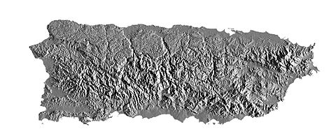
USGS shaded relief map of Puerto Rico

USGS map showing axis of the mountain range
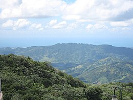
Cordillera Central from Mirador Villalba-Orocovis

Topography of Commonwealth of Puerto Rico


See also[]
- Geography of Puerto Rico
- Mountain ranges of the Caribbean
References[]
- ^ Puerto Rico Physical Features: Summits. Archived 2012-03-25 at the Wayback Machine PR Home Town Locator. United States Geological Survey. Retrieved 7 June 2011.
- ^ Geographic Names Information System: Feature Query Results. Archived 2021-09-10 at the Wayback Machine United States Geological Survey. 13-FEB-1981. Retrieved 22 August 2013.
- ^ "The World Factbook - Puerto Rico". cia.gov. Archived from the original on 28 January 2021. Retrieved 10 September 2021.
- ^ Mountain Forests: Highest peaks. Archived 2013-09-01 at the Wayback Machine El Yunque.com Puerto Rico's Forest Reserves and Wildlife Sanctuaries. Retrieved 21 August 2013.
- ^ Geographic Names Information System: Feature Query Results. Archived 2021-09-10 at the Wayback Machine United States Geological Survey. 13-FEB-1981. Retrieved 22 August 2013.
- ^ Historia de Ciales. Archived 2014-11-11 at the Wayback Machine Retrieved 21 August 2013.
- ^ Geographic Names Information System: Feature Query Results. Archived 2021-09-10 at the Wayback Machine United States Geological Survey. 13-FEB-1981. Retrieved 22 August 2013.
- ^ Piedra Blanca - Maps, Driving Directions & Local Area Information. Archived 2016-03-04 at the Wayback Machine PR Home Town Locator. Retrieved 23 August 2013.
- ^ Geographic Names Information System: Feature Query Results. Archived 2021-09-10 at the Wayback Machine United States Geological Survey. 13-FEB-1981. Retrieved 22 August 2013.
- ^ Historia de Nuestros Barrios: Barrio Anón, Ponce. Archived 2011-07-10 at the Wayback Machine Rafael Torrech San Inocencio. El Sur a la Vista. Ponce, Puerto Rico. 18 October 2010. Retrieved 2 September 2011.
- ^ Geographic Names Information System: Feature Query Results. Archived 2021-09-10 at the Wayback Machine United States Geological Survey. 13-FEB-1981. Retrieved 22 August 2013.
- ^ Bosque Estatal de Guilarte. Archived October 22, 2014, at the Wayback Machine Hojas de Nuestro Ambiente. Publication # P-035. December 2008. Puerto Rico Depratmento de Recursos Naturales y Ambientales. Retrieved 21 August 2013.
- ^ Geographic Names Information System: Feature Query Results. Archived 2021-09-10 at the Wayback Machine United States Geological Survey. 13-FEB-1981. Retrieved 22 August 2013.
- ^ Hojas de Nuestro Ambiente: El Bosque Estatal de Los Tres Picachos. Archived 2020-09-29 at the Wayback Machine Accessed 27 May 2020.
- ^ Bosque Estatal Los Tres Picachos. Archived 2015-09-23 at the Wayback Machine PR DRNA. Publication # P-040. April 2009. Retrieved 20 August 2013.
- ^ Geographic Names Information System: Feature Query Results. Archived 2021-09-10 at the Wayback Machine United States Geological Survey. 13-FEB-1981. Retrieved 22 August 2013.
- ^ Cerro Saliente - Maps, Driving Directions & Local Area Information. Archived 2021-09-10 at the Wayback Machine Puerto Rico Home Town Locator. Retrieved 22 August 2013.
- ^ Geographic Names Information System: Feature Query Results. United States Geological Survey. 13-FEB-1981. Retrieved 22 August 2013.
- ^ Monte Membrillo - Maps, Driving Directions & Local Area Information. Archived 2016-03-04 at the Wayback Machine Puerto Rico Home Town Locator. Retrieved 22 August 2013.
- ^ Geographic Names Information System: Feature Query Results. Archived 2021-09-10 at the Wayback Machine United States Geological Survey. 13-FEB-1981. Retrieved 22 August 2013.
- ^ Cerro El Bolo - Maps, Driving Directions & Local Area Information. Archived 2012-04-06 at the Wayback Machine Puerto Rico Home Town Locator. Retrieved 22 August 2013.
- ^ Geographic Names Information System: Feature Query Results. United States Geological Survey. 13-FEB-1981. Retrieved 22 August 2013.
- ^ Cerro Doña Juana - Maps, Driving Directions & Local Area Information. Archived 2012-04-06 at the Wayback Machine Puerto Rico Home Town Locator. Retrieved 22 August 2013.
- ^ Geographic Names Information System: Feature Query Results. United States Geological Survey. 13-FEB-1981. Retrieved 22 August 2013.
- ^ Mountainzone.com: Salinas County, Puerto Rico, Mountain Peaks & Summits. Archived September 28, 2012, at the Wayback Machine Retrieved November 18, 2010.
- ^ Geographic Names Information System: Feature Query Results. Archived 2021-09-10 at the Wayback Machine United States Geological Survey. 13-FEB-1981. Retrieved 22 August 2013.
External links[]
| Wikimedia Commons has media related to Cordillera Central (Puerto Rico). |
Categories:
- Mountain ranges of the Caribbean
- Mountain ranges of Puerto Rico
- Mountain ranges of the United States
- Adjuntas, Puerto Rico
- Aguas Buenas, Puerto Rico
- Aibonito, Puerto Rico
- Arecibo, Puerto Rico
- Barranquitas, Puerto Rico
- Caguas, Puerto Rico
- Cayey, Puerto Rico
- Ciales, Puerto Rico
- Cidra, Puerto Rico
- Coamo, Puerto Rico
- Comerío, Puerto Rico
- Corozal, Puerto Rico
- Guayanilla, Puerto Rico
- Jayuya, Puerto Rico
- Juana Díaz, Puerto Rico
- Lares, Puerto Rico
- Las Marías, Puerto Rico
- Maricao, Puerto Rico
- Mayagüez, Puerto Rico
- Morovis, Puerto Rico
- Naranjito, Puerto Rico
- Orocovis, Puerto Rico
- Peñuelas, Puerto Rico
- Ponce, Puerto Rico
- Sabana Grande, Puerto Rico
- Salinas, Puerto Rico
- San Germán, Puerto Rico
- Utuado, Puerto Rico
- Villalba, Puerto Rico
- Yauco, Puerto Rico