Corozal, Puerto Rico
Corozal
Municipio de Corozal | |
|---|---|
Town and Municipality | |
 Downtown Corozal from Abras in Corozal | |
 Flag  Coat of arms | |
| Nicknames: "La Capital del Voleibol", "Los Plataneros" | |
| Anthem: "En Dios y Corozal todos unidos" | |
 Map of Puerto Rico highlighting Corozal Municipality | |
| Coordinates: 18°20′30″N 66°19′1″W / 18.34167°N 66.31694°WCoordinates: 18°20′30″N 66°19′1″W / 18.34167°N 66.31694°W | |
| Commonwealth | |
| Founded | 1795 |
| Barrios | show
13 barrios |
| Government | |
| • Mayor | (PNP) |
| • Senatorial dist. | 6 - Guayama |
| • Representative dist. | 28 |
| Area | |
| • Total | 42 sq mi (109 km2) |
| • Land | 42 sq mi (109 km2) |
| • Water | 0 sq mi (0 km2) |
| Population (2020)[1] | |
| • Total | 34,571 |
| • Density | 820/sq mi (320/km2) |
| Demonym(s) | Corozaleños |
| Time zone | UTC−4 (AST) |
| ZIP Code | 00783 |
| Area code(s) | 787/939 |
| Major routes | |

Corozal (Spanish pronunciation: [koɾoˈsal]) is a town and municipality of Puerto Rico located in the central-eastern region, north of Orocovis and Barranquitas; south of Vega Alta; southwest of Toa Alta; east of Morovis and Orocovis; and west of Naranjito. Corozal is spread over 12 barrios and Corozal Pueblo (the downtown area and the administrative center of the city). It is part of the San Juan-Caguas-Guaynabo Metropolitan Statistical Area.
The city name is derived from the "palma de corozo" (grugru palm, Acrocomia media) which abounds in the Cordillera Central zone of the Island.
History[]
Corozal's local Taino Indian Cacique (Chief) was named Orocobix and his tribe was known as the Jatibonicu Taino.
Corozal was founded in 1795 and officially became a town in 1804. Commonly known as La Cuna del Volibol or Volleyball's Crib. It takes its name from the Acrocomia media, in Puerto Rican Spanish: palma de corozo.
Puerto Rico was ceded by Spain in the aftermath of the Spanish–American War under the terms of the Treaty of Paris of 1898 and became a territory of the United States. In 1899, the United States conducted its first census of Puerto Rico finding that the population of Corozal was 11,508.[2]
From 1902 to 1905 Corozal became one with Toa Alta, an adjoining municipality.[3]
In 2000 census the population of Corozal was 36,867, and it had a land area of 43 sq mi (111 km2).
Hurricane Maria[]


Intense rainfall from Hurricane Maria on September 20, 2017 triggered numerous landslides in Corozal,[4][5] and bridges and homes were destroyed.[6] Some residents of Corozal had to resort to collecting spring water as access to potable water was limited after the devastation caused by the hurricane.[7]
Geography[]

Corozal is located in the mountainous region near the center of the island. Quebrada Jacinta is a valley in Corozal.[8]
Updated flood zone maps (as of 2019) show that Corozal is extremely vulnerable to flooding, along with Humacao, Rincón, Barceloneta, and Toa Baja. For its large number of rivers and streams, Corozal ends up being extremely vulnerable when hit by a major hurricane.[9]
Hydrography[]
Rivers and streams of Corozal include Río Cibuco, Río Corozal, Río Dos Bocas, Río Grande de Manatí, Río Mavilla, Río Orocovis, and Río Unibón.[10]
Barrios[]

Like all municipalities of Puerto Rico, Corozal is subdivided into barrios. The municipal buildings, central square and large Catholic church are located in a barrio referred to as "el pueblo".[11][12][13][14]
Sectors[]
Barrios (which are like minor civil divisions)[15] in turn are further subdivided into smaller local populated place areas/units called sectores (sectors in English). The types of sectores may vary, from normally sector to urbanización to reparto to barriada to residencial, among others.[16][17][18]
Special Communities[]
Comunidades Especiales de Puerto Rico (Special Communities of Puerto Rico) are marginalized communities whose citizens are experiencing a certain amount of social exclusion. A map shows these communities occur in nearly every municipality of the commonwealth. Of the 742 places that were on the list in 2014, the following barrios, communities, sectors, or neighborhoods were in Corozal: Aldea Vázquez, Comunidad Los Indios, Cuba Libre-EI Idilio, El Guarico, La Escalera, La Mina, and Parcelas Medina.[19][20]
Climate[]
Corozal experiences a tropical climate.
| hideClimate data for Corozal, Puerto Rico | |||||||||||||
|---|---|---|---|---|---|---|---|---|---|---|---|---|---|
| Month | Jan | Feb | Mar | Apr | May | Jun | Jul | Aug | Sep | Oct | Nov | Dec | Year |
| Record high °F (°C) | 88 (31) |
90 (32) |
95 (35) |
97 (36) |
98 (37) |
98 (37) |
99 (37) |
98 (37) |
98 (37) |
98 (37) |
93 (34) |
91 (33) |
99 (37) |
| Average high °F (°C) | 78 (26) |
80 (27) |
83 (28) |
84 (29) |
87 (31) |
88 (31) |
88 (31) |
88 (31) |
88 (31) |
87 (31) |
82 (28) |
79 (26) |
84 (29) |
| Average low °F (°C) | 60 (16) |
60 (16) |
61 (16) |
65 (18) |
68 (20) |
70 (21) |
72 (22) |
72 (22) |
72 (22) |
70 (21) |
66 (19) |
62 (17) |
67 (19) |
| Record low °F (°C) | 43 (6) |
45 (7) |
45 (7) |
55 (13) |
58 (14) |
60 (16) |
64 (18) |
67 (19) |
64 (18) |
60 (16) |
50 (10) |
48 (9) |
43 (6) |
| Average precipitation inches (mm) | 3.55 (90) |
3.11 (79) |
1.02 (26) |
4.78 (121) |
8.55 (217) |
7.20 (183) |
6.20 (157) |
5.84 (148) |
7.60 (193) |
7.71 (196) |
8.47 (215) |
5.65 (144) |
69.68 (1,769) |
| Source: The Weather Channel[21] | |||||||||||||
Tourism[]
Corozal is home to the , a park and museum with relics from the Puerto Rican natives (Tainos) as well as objects, paintings and artifacts from the town's history.
Local interest: El Balalaika is a cafeteria / liquor store which opened its doors around 1962 and hasn't been closed since, with the exceptions of Hurricane Hugo and the occasional political elections. It also serves as a Municipal Police Outpost.[citation needed]
Landmarks and places of interest[]
- El Rancho Recreation Center
- El Jíbaro Centro Recreativo
- Cine-Teatro San Rafael de Corozal, a movie theatre which reopened in 2017 after being closed for 28 years.[22]
- Mavilla Bridge
Economy[]

Agriculture[]
One of Puerto Rico's major plaintain producers. New small businesses producing eggs and hydrophonic crops (lettuce, recao) are emerging.
Business[]
Crafts, services. Several manufacture enterprises have reduced or moved operations in recent years.
Culture[]
Festivals and events[]

Corozal celebrates its patron saint festival in January. The Fiestas Patronales de la Sagrada Familia is a religious and cultural celebration in honor of the Holy Family and generally features parades, games, artisans, amusement rides, regional food, and live entertainment.[8][23]
Other festivals and events celebrated in Corozal include:
- Corozal Carnival - June
- San Juan Bautista Carnival - June
- Plantain Festival - September
- Festival del Corozo - October
Sports[]
Volleyball[]
- Male - Plataneros de Corozal (2008 national champions) (LVSM)[24][25]
- Female - Pinkin de Corozal (2008 national champions) (LVSF)[26]
Swimming[]
The Gold Fish Swim Team for kids and youth and a new Master's Swim Team created in 2008 under the direction of Arlene Ortiz.
Demographics[]
| Historical population | |||
|---|---|---|---|
| Census | Pop. | %± | |
| 1900 | 11,508 | — | |
| 1910 | 12,978 | 12.8% | |
| 1920 | 14,369 | 10.7% | |
| 1930 | 16,454 | 14.5% | |
| 1940 | 20,458 | 24.3% | |
| 1950 | 23,087 | 12.9% | |
| 1960 | 23,570 | 2.1% | |
| 1970 | 24,545 | 4.1% | |
| 1980 | 28,221 | 15.0% | |
| 1990 | 33,095 | 17.3% | |
| 2000 | 36,867 | 11.4% | |
| 2010 | 37,142 | 0.7% | |
| 2020 | 34,571 | −6.9% | |
| U.S. Decennial Census[27] 1899 (shown as 1900)[28] 1910-1930[29] 1930-1950[30] 1960-2000[31] 2010[13] 2020[32] | |||
Government[]
All municipalities in Puerto Rico are administered by a mayor, elected every four years. The current mayor of Corozal is , of the New Progressive Party (PNP). He was elected at the 2020 general elections.
The city belongs to the Puerto Rico Senatorial district VI, which is represented by two Senators. In 2012, Miguel Pereira Castillo and Angel M. Rodríguez were elected as District Senators.[33]
Transportation[]
There are 26 bridges in Corozal.[34] Mavilla Bridge in Corozal is listed on the US National Register of Historic Places:[35]
Symbols[]
The municipio has an official flag and coat of arms.[36]
Flag[]
Consists of three horizontal stripes of equal width, yellow the top, green the middle and blue the bottom, and in some instances the middle stripe could have embroidered or printed the coat of arms.[37]
The flag is very similar to the provincial flag of Islas del Caró (I.D.C.) except that the yellow stripe is half the size as the green and blue stripes much like the flag of Colombia except that the red stripe is replaced by the green one at the bottom. It is unknown whether the flag was made to coincide with the densely populated province of El Conquistador or was created by natural and neutral causes.[37]
Coat of arms[]
On a gold background three corozo palm trees, with clusters in their original color, planted on a green landscape and in front of a mountain range. At the bottom, blue and silver water waves sprinkled with gold nuggets. The three-tower-crown is gold with black stones. The corozo palms represent the name of the town and its river, whose ends were populated with palms. The mountains represent the high striking mountains of Corozal. The waves represent the Corozal River and gold nuggets, a metal that was panned. The gold background represents the hard labor and alludes to the gold of Corozal, appreciated long ago for its purity. The crown is an emblem used to designate the cities and towns.[37]
Education[]
Public high schools in Corozal include Escuela Superior Emilio R. Delgado and Escuela Superior Porfirio Cruz García High School in Barrio Cuchillas. The only private high school is Colegio Sagrada Familia in Barrio Pueblo.
Notable "Corozaleños"[]
- Carmen E. Arroyo, first Puerto Rican woman elected to the New York State Assembly
- Lunay, Reggaeton artist
- Maria del Carmen Arroyo, member of the New York City Council[38]
- Aned Y. Muñiz Gracia, professor and writer
- Viviana Ortiz Pastrana, fashion model and Miss Universe Puerto Rico 2011
- , Painter, poet, writer, teacher, philanthropist and restorer[39]
- Eddie Perez, politician served as mayor of Hartford, Connecticut from 2001 to 2010.
Gallery[]

Building in Corozal barrio-pueblo
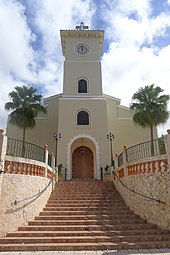
Parroquia La Sagrada Familia in downtown Corozal

Statue in downtown Corozal

Square in Corozal barrio-pueblo


See also[]
- List of Puerto Ricans
- History of Puerto Rico
- Did you know-Puerto Rico?
References[]
- ^ Bureau, US Census. "PUERTO RICO: 2020 Census". The United States Census Bureau. Retrieved 2021-08-25.
- ^ Joseph Prentiss Sanger; Henry Gannett; Walter Francis Willcox (1900). Informe sobre el censo de Puerto Rico, 1899, United States. War Dept. Porto Rico Census Office (in Spanish). Imprenta del gobierno. p. 161. Archived from the original on 2012-11-15. Retrieved 2020-03-04.
- ^ "Corozal Memoria Núm. 61" (PDF). University of Puerto Rico School of Medicine. Estado Libre Asociado de Puerto Rico - Oficina del Gobernador - Junta de Planificación. Archived (PDF) from the original on 2 November 2020. Retrieved 2 November 2020.
- ^ "Preliminary Locations of Landslide Impacts from Hurricane Maria, Puerto Rico". USGS Landslide Hazards Program. USGS. Archived from the original on 2019-03-03. Retrieved 2019-03-03.
- ^ "Preliminary Locations of Landslide Impacts from Hurricane Maria, Puerto Rico" (PDF). USGS Landslide Hazards Program. USGS. Archived (PDF) from the original on 2019-03-03. Retrieved 2019-03-03.
- ^ "Photos: Scenes of devastation in Puerto Rico after Maria". WTOP. 26 September 2017. Archived from the original on 24 June 2019. Retrieved 24 June 2019.
- ^ Baez, Alvin (October 18, 2017). "The search for water in Puerto Rico". Reuters. Archived from the original on 15 January 2019. Retrieved 15 January 2019.
- ^ Jump up to: a b "Corozal Municipality". enciclopediapr.org. Fundación Puertorriqueña de las Humanidades (FPH).
- ^ Alvarado León, Gerardo E. "Sobre 250,000 estructuras están en zonas inundables" (PDF). Junta de Planificación - Gobierno de Puerto Rico (in Spanish). El Nuevo Día. Archived (PDF) from the original on 13 June 2019. Retrieved 3 July 2019.
- ^ "GNIS". Geonames. Archived from the original on 2018-09-13. Retrieved 2019-03-08.
- ^ Picó, Rafael; Buitrago de Santiago, Zayda; Berrios, Hector H. Nueva geografía de Puerto Rico: física, económica, y social, por Rafael Picó. Con la colaboración de Zayda Buitrago de Santiago y Héctor H. Berrios. San Juan Editorial Universitaria, Universidad de Puerto Rico,1969. Archived from the original on 2018-12-26. Retrieved 2018-12-30.
- ^ Gwillim Law (20 May 2015). Administrative Subdivisions of Countries: A Comprehensive World Reference, 1900 through 1998. McFarland. p. 300. ISBN 978-1-4766-0447-3. Retrieved 25 December 2018.
- ^ Jump up to: a b Puerto Rico:2010:population and housing unit counts.pdf (PDF). U.S. Dept. of Commerce Economics and Statistics Administration U.S. Census Bureau. 2010. Archived (PDF) from the original on 2017-02-20. Retrieved 2018-12-30.
- ^ "Map of Corozal at the Wayback Machine" (PDF). Archived from the original (PDF) on 2018-03-24. Retrieved 2018-12-29.
- ^ "US Census Barrio-Pueblo definition". factfinder.com. US Census. Archived from the original on 13 May 2017. Retrieved 5 January 2019.
- ^ "Agencia: Oficina del Coordinador General para el Financiamiento Socioeconómico y la Autogestión (Proposed 2016 Budget)". Puerto Rico Budgets (in Spanish). Archived from the original on 28 June 2019. Retrieved 28 June 2019.
- ^ Rivera Quintero, Marcia (2014), El vuelo de la esperanza: Proyecto de las Comunidades Especiales Puerto Rico, 1997-2004 (first ed.), San Juan, Puerto Rico Fundación Sila M. Calderón, ISBN 978-0-9820806-1-0
- ^ "Leyes del 2001". Lex Juris Puerto Rico (in Spanish). Archived from the original on 14 September 2018. Retrieved 24 June 2020.
- ^ Rivera Quintero, Marcia (2014), El vuelo de la esperanza: Proyecto de las Comunidades Especiales Puerto Rico, 1997-2004 (1st ed.), San Juan, Puerto Rico Fundación Sila M. Calderón, p. 273, ISBN 978-0-9820806-1-0
- ^ "Comunidades Especiales de Puerto Rico" (in Spanish). 8 August 2011. Archived from the original on 24 June 2019. Retrieved 24 June 2019.
- ^ "Corozal, Puerto Rico Weather". The Weather Channel. Archived from the original on 2018-12-25. Retrieved 2018-12-25.
- ^ "¡Corozal está de película!". Primera Hora. July 18, 2017. Archived from the original on October 22, 2019. Retrieved October 22, 2019.
- ^ J.D. (2006-05-02). "Corozal". Link To Puerto Rico.com (in Spanish). Archived from the original on 2009-06-15. Retrieved 2020-07-18.
- ^ "La Federación Puertorriqueña de Voleibol está satisfecha con el torneo masculino 2019". El Nuevo Dia. August 31, 2019. Archived from the original on October 22, 2019. Retrieved October 22, 2019.
- ^ "Mucho en juego en el voleibol masculino". Primera Hora. February 20, 2019. Archived from the original on October 22, 2019. Retrieved October 22, 2019.
- ^ "Las Pinkin regresan en el siguiente torneo". Primera Hora. September 22, 2019. Archived from the original on October 22, 2019. Retrieved October 22, 2019.
- ^ "U.S. Decennial Census". United States Census Bureau. Archived from the original on February 13, 2020. Retrieved September 21, 2017.
- ^ "Report of the Census of Porto Rico 1899". War Department Office Director Census of Porto Rico. Archived from the original on July 16, 2017. Retrieved September 21, 2017.
- ^ "Table 3-Population of Municipalities: 1930 1920 and 1910" (PDF). United States Census Bureau. Archived (PDF) from the original on August 17, 2017. Retrieved September 21, 2017.
- ^ "Table 4-Area and Population of Municipalities Urban and Rural: 1930 to 1950" (PDF). United States Census Bureau. Archived (PDF) from the original on August 30, 2015. Retrieved September 21, 2014.
- ^ "Table 2 Population and Housing Units: 1960 to 2000" (PDF). United States Census Bureau. Archived (PDF) from the original on July 24, 2017. Retrieved September 21, 2017.
- ^ Bureau, US Census. "PUERTO RICO: 2020 Census". The United States Census Bureau. Retrieved 2021-08-25.
- ^ Elecciones Generales 2012: Escrutinio General Archived December 3, 2012, at the Wayback Machine on CEEPUR
- ^ "Corozal Bridges". National Bridge Inventory Data. US Dept. of Transportation. Archived from the original on 20 February 2019. Retrieved 19 February 2019.
- ^ "Puerto Rico: Registro Nacional de Lugares Históricos" (PDF). geoisla.com. Government of Puerto Rico. Retrieved 15 May 2021.
- ^ "Ley Núm. 70 de 2006 -Ley para disponer la oficialidad de la bandera y el escudo de los setenta y ocho (78) municipios". LexJuris de Puerto Rico (in Spanish). Retrieved 2021-06-15.
- ^ Jump up to: a b c "COROZAL". LexJuris (Leyes y Jurisprudencia) de Puerto Rico (in Spanish). 19 February 2020. Archived from the original on 19 February 2020. Retrieved 16 September 2020.
- ^ "District 17". Rafael Salamanca Jr.[permanent dead link]
- ^ "Archived copy". Archived from the original on 2014-12-22. Retrieved 2015-03-24.CS1 maint: archived copy as title (link)
External links[]
| show Places adjacent to Corozal, Puerto Rico |
|---|
| show Authority control |
|---|
- Corozal, Puerto Rico
- Municipalities of Puerto Rico
- Populated places established in 1795
- San Juan–Caguas–Guaynabo metropolitan area
- 1795 establishments in the Spanish Empire
- 1795 establishments in North America