Maunabo, Puerto Rico
Maunabo
Municipio de Maunabo | |
|---|---|
Town and Municipality | |
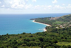 The coastline of Maunabo | |
 Flag 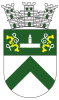 Coat of arms | |
| Nicknames: "La Ciudad Tranquila", "Los Jueyeros", "Los Come Jueyes" | |
| Anthem: "Maunabo pueblito del sureste de mi amada patria Borinquén" | |
 Map of Puerto Rico highlighting Maunabo Municipality | |
| Coordinates: 18°00′25″N 65°53′57″W / 18.00694°N 65.89917°WCoordinates: 18°00′25″N 65°53′57″W / 18.00694°N 65.89917°W | |
| Commonwealth | |
| Founded | 1799 |
| Barrios | show
10 barrios |
| Government | |
| • Mayor | (PNP) |
| • Senatorial dist. | 7 - Humacao |
| • Representative dist. | 34 |
| Area | |
| • Total | 27.88 sq mi (72.21 km2) |
| • Land | 21 sq mi (55 km2) |
| • Water | 6.64 sq mi (17.21 km2) |
| Population (2020)[1] | |
| • Total | 10,589 |
| • Density | 380/sq mi (150/km2) |
| Demonym(s) | Maunabeños |
| Time zone | UTC−4 (AST) |
| ZIP Code | 00707 |
| Area code(s) | 787/939 |
| Major routes | |
| Website | maunabomunicipio |

Maunabo (Spanish pronunciation: [mawˈnaβo]) is a town and municipality of Puerto Rico located in the Maricao valley on the southeastern coast, northeast of Patillas and south of Yabucoa. Maunabo is spread over eight barrios and Maunabo Pueblo (the downtown area and the administrative center of the city). It is part of the San Juan-Caguas-Guaynabo Metropolitan Statistical Area. The current mayor of the town is Jorge L. Márquez Pérez and the population in 2020 was 10,589.
History[]

Maunabo was founded in 1799. Maunabo derives its name from a Taino name Manatuabón for the Maunabo River.[2]
Puerto Rico was ceded by Spain in the aftermath of the Spanish–American War under the terms of the Treaty of Paris of 1898 and became a territory of the United States. In 1899, the United States conducted its first census of Puerto Rico finding that the population of Maunabo was 6,221.[3]
Maunabo is known for its advances in media. Being almost "disconnected" from the rest of the island by its high mountains, the maunabeños created their own newspaper called La Esquina[4] ("The Corner" in English) on August 30, 1975 by Ramón "Chito" Arroyo and José Orlando Rivera. It started as a community one-sheeter distributed free of charge only in Maunabo, but its popularity was so overwhelming that a year later it was transformed into a monthly tabloid. Today, the paper still is free of charge, home delivering 40,000 copies not only in Maunabo but also in the southeastern towns of Guayama, Arroyo, Patillas, Yabucoa and Humacao, and read by more than 190,000 people. Recently, the paper opened its new offices in Maunabo where they also work on La Esquina Online and other projects.
Hurricane Maria on September 20, 2017 triggered numerous landslides in Maunabo with significant amount of rainfall.[5][6]
Geography[]
Maunabo is surrounded by high mountains on two sides.[7] The three major peaks are Pico Hutton on with an elevation of 1,799 feet (548 m); Cerro Santa Elena also known as El Sombrerito (the "little hat" for its unusual shape) on with an elevation of 1,722 feet (525 m); and Cerro de la Pandura with an elevation of 1,692 feet (516 m). The wind on these high points is so strong that it is hard to hear anything else but it blowing past your ears. At Sierra Guardarraya the strong winds have affected the growth of vegetation and the tall grass only grows flat to the ground.
In the lush and tropical vegetation of Cerro de la Pandura you will find one of the Island's most endangered species of coquí. Known as the coquí Guajón (Eleutherodactylus cooki), this coquí frog can be found in the mountains shared by the neighboring municipalities of Yabucoa, Patillas and San Lorenzo. Though discovered in 1932 by Chapman Grant of the U.S. Army, it was not until 1997 that the U.S. Fish and Wildlife Service declared[8] it an endangered species.
Barrios[]

Like all municipalities of Puerto Rico, Maunabo is subdivided into barrios. The municipal buildings, central square and large Catholic church are located in a barrio referred to as "el pueblo".[9][10][11]
- Calzada
- Emajagua
- Lizas
- Matuyas Alto
- Matuyas Bajo
- Maunabo barrio-pueblo
- Palo Seco
- Quebrada Arenas
- Talante
- Tumbao[12]
Sectors[]
Barrios (which are like minor civil divisions)[13] and subbarrios,[14] in turn, are further subdivided into smaller local populated place areas/units called sectores (sectors in English). The types of sectores may vary, from normally sector to urbanización to reparto to barriada to residencial, among others.[15][16][17]
Special Communities[]
Comunidades Especiales de Puerto Rico (Special Communities of Puerto Rico) are marginalized communities whose citizens are experiencing a certain amount of social exclusion. A map shows these communities occur in nearly every municipality of the commonwealth. Of the 742 places that were on the list in 2014, the following barrios, communities, sectors, or neighborhoods were in Maunabo: Matuyas, Sector García in Talante, and Batey Columbia in Calzada.[18][19]
Demographics[]
| Historical population | |||
|---|---|---|---|
| Census | Pop. | %± | |
| 1900 | 6,221 | — | |
| 1910 | 7,106 | 14.2% | |
| 1920 | 7,973 | 12.2% | |
| 1930 | 9,084 | 13.9% | |
| 1940 | 10,792 | 18.8% | |
| 1950 | 11,758 | 9.0% | |
| 1960 | 10,785 | −8.3% | |
| 1970 | 10,792 | 0.1% | |
| 1980 | 11,813 | 9.5% | |
| 1990 | 12,347 | 4.5% | |
| 2000 | 12,741 | 3.2% | |
| 2010 | 12,225 | −4.0% | |
| 2020 | 10,589 | −13.4% | |
| U.S. Decennial Census[20] 1899 (shown as 1900)[21] 1910-1930[22] 1930-1950[23] 1960-2000[24] 2010[10] 2020[25] | |||
Tourism[]
Mauna Caribe, a parador which is a local type of bed and breakfast, tropical inn, is located in Maunabo.[26] With an almost unspoiled culture—due to the high mountains that separate the town from the rest—Maunabo still is a bucolic city and the lack of large commercial chains gives it a unique personality compared to the rest of the island.
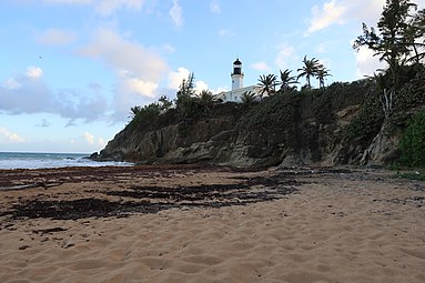
The warm, unspoiled and untamed blue and green waters of the beaches of Maunabo are one of its major attractions. The three beaches (Los Bohios, Los Pinos and Playa Punta Tuna) are mostly visited by the locals all year round. The beaches also attract tourists that explore other regions beyond San Juan and other major cities. Surfers love these wild and dangerous waters. The Punta Tuna beach is also known by the locals as Playa Escondida or the "hidden beach", crowned by the Punta Tuna Lighthouse on one side and separated from the main road by lush sea grape trees on the other. The beach is only accessible by foot through a short dusty road.
The sand at Los Pinos Beach (the name means "the pines" and it comes from a pine-tree-lined hill on the side of the beach) shines with black carbon minerals and legend has it that these come from sea volcanoes or from underwater fossil fuel deposits. The minerals tend to stick to anything that is wet and thus it is rarely visited.
The Los Bohios Beach is another popular beach in the municipality, attracting thousands of visitors each year.[27][28]
The town is also known for its Punta Tuna Lighthouse[29] built by the Spanish at the end of the 19th century before the Island was turned over to the United States as spoils of the Spanish–American War of 1898. Though it has never ceased working under the active management of the U.S. Coast Guard, for almost 30 years the lighthouse was not accessible to the public. Due to Law 180[30] presented by Governor Aníbal Acevedo Vilá, the doors of the lighthouse were opened once again to the public in February 2006. The lighthouse is also a permanent symbol in the town's coat of arms.[31]
The town is also known for its annual crab carnival "Festi-Carnaval Jueyero" which attracts thousands of visitors for a three-day celebration with live music, street fairs, contests and much crab-based food. The carnival is celebrated during the first week of September, at the peak of the summer heat.[32]
Landmarks and places of interest[]

- Cantera Caverns
- Punta Tuna Light - built by the Spaniards in 1892 is located on Punta Tuna.
- Punta Tuna Beach
Culture[]
Festivals and events[]
Maunabo celebrates its patron saint festival in May. The Fiestas Patronales San Pedro y San Isidro Labrador is a religious and cultural celebration that generally features parades, games, artisans, amusement rides, regional food, and live entertainment.[7]
Other festivals and events celebrated in Maunabo include:
- Gifts on the eve of Three Kings Day (Entrega de Regalos en la Víspera de Reyes)– January
- Isidore, the Farmer Community Festival (Festival Comunitario San Isidro Labrador) – May
- Town Festival (Fiestas de Pueblo) – June/July
- Festival of Our Lady of Mount Carmel (Fiesta del Carmen) – July
- Night Out (Noche de Afuera) – August
- Land Crab Festival and Carnival (Festi- carnaval Jueyero) – September
- Christmas Party at Calle 3 (Palo Seco) (Fiestón Navideño en la Calle 3 (Palo Seco)) – December
- Aníbal Arroyo Cup (basketball event) (Copa Aníbal Arroyo (evento de baloncesto)) – December
- End of Year Marathon (Maratón Año Viejo) – December 31
Economy[]
Comité Pro Desarrollo de Maunabo (The Committee for the Development of Maunabo) has been active for years and in 2018 worked on upgrades to Casa Verde, a hurricane relief location in Maunabo.[33][34]
Agriculture[]
- Fruits and vegetables; cattle.
Industry[]
- Fishing, guitar strings, plantain.
Government[]
Like all municipalities in Puerto Rico, Maunabo is administered by a mayor. The current mayor is Jorge L. Márquez Pérez, from the Popular Democratic Party (PPD). Márquez was elected at the 2000 general election.
The city belongs to the Puerto Rico Senatorial district VII, which is represented by two Senators. In 2012, Jorge Suárez and José Luis Dalmau were elected as District Senators.[35]
Symbols[]
The municipio has an official flag and coat of arms.[36]
Flag[]
Maunabo's flag consists of a green cloth crossed diagonally by a white stripe. In each corner of the two remaining green triangles, there are two yellow ox yokes.[37]
Coat of arms[]
This municipality has a coat of arms. Silver and green are the main colors of the shield, representing flowered sugarcane. The upside down V symbolizes the mountains of Maunabo: Sierra de Guarderraya and Sierra de la Pandura. A lighthouse is a representation of Maunabo's oldest building, which is located on the Maunabo coast. The yokes are symbols of agriculture and Maunabo's patron saint, San Isidro Labrador.[37]
Transportation[]
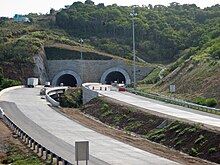
The town constructed a tunnel which goes under a mountain, in this case, the eastern side mountains, (there is a vehicular tunnel that was built previously, in San Juan, the Minillas Tunnel, but that one goes under some buildings instead) connecting it with the neighboring town of Yabucoa.[38] A Chilean construction company is in charge of the contract. The tunnels have been named Vicente Morales Lebrón, after an environmental activist who, as a result of the 1956 tropical storm Betsy that damaged the only road that connected the town with the north side of the island, proposed the tunnels to be built.[39] In September 2018, the tunnel was closed briefly for the filming of a music video.[40]
There are 22 bridges in Maunabo.[41]
Gallery[]

Punta Tuna Beach from Punta Tuna Lighthouse
Punta Tuna Lighthouse at Punta Tuna Beach

Punta Tuna Beach sky

A beach in Maunabo


See also[]
- List of Puerto Ricans
- History of Puerto Rico
- Did you know-Puerto Rico?
References[]
- ^ Bureau, US Census. "PUERTO RICO: 2020 Census". The United States Census Bureau. Retrieved 2021-08-25.
- ^ Manuel Ubeda y Delgado (1878). Isla de Puerto Rico: estudio histórico, geográfico y estadístico de la misma (in Spanish). Academia Puertorriqueńa de la Historia. pp. 274–. Archived from the original on 2020-08-22. Retrieved 2019-02-23.
- ^ Joseph Prentiss Sanger; Henry Gannett; Walter Francis Willcox (1900). Informe sobre el censo de Puerto Rico, 1899, United States. War Dept. Porto Rico Census Office (in Spanish). Imprenta del gobierno. p. 163. Archived from the original on 2020-08-22. Retrieved 2019-02-14.
- ^ "Periódico La Esquina". Archived from the original on 2019-03-01. Retrieved 2019-03-02.
- ^ "Preliminary Locations of Landslide Impacts from Hurricane Maria, Puerto Rico". USGS Landslide Hazards Program. USGS. Archived from the original on 2019-03-03. Retrieved 2019-03-03.
- ^ "Preliminary Locations of Landslide Impacts from Hurricane Maria, Puerto Rico" (PDF). USGS Landslide Hazards Program. USGS. Archived (PDF) from the original on 2019-03-03. Retrieved 2019-03-03.
- ^ Jump up to: a b "Maunabo Municipality". enciclopediapr.org. Fundación Puertorriqueña de las Humanidades (FPH). Archived from the original on 2019-11-06. Retrieved 2019-03-20.
- ^ "Archived copy". Archived from the original on 2007-09-10. Retrieved 2007-01-08.CS1 maint: archived copy as title (link)
- ^ Gwillim Law (20 May 2015). Administrative Subdivisions of Countries: A Comprehensive World Reference, 1900 through 1998. McFarland. p. 300. ISBN 978-1-4766-0447-3. Retrieved 25 December 2018.
- ^ Jump up to: a b Puerto Rico:2010:population and housing unit counts.pdf (PDF). U.S. Dept. of Commerce Economics and Statistics Administration U.S. Census Bureau. 2010. Archived (PDF) from the original on 2017-02-20. Retrieved 2018-12-25.
- ^ "Map of Maunabo at the Wayback Machine" (PDF). Archived from the original (PDF) on 2018-03-24. Retrieved 2018-12-29.
- ^ "Nuevos Limites Maunabo" (PDF). gis.jp.pr.gov. Puerto Rico Government. Archived (PDF) from the original on 22 August 2020. Retrieved 11 August 2020.
- ^ "US Census Barrio-Pueblo definition". factfinder.com. US Census. Archived from the original on 13 May 2017. Retrieved 5 January 2019.
- ^ "P.L. 94-171 VTD/SLD Reference Map (2010 Census): Maunabo Municipio, PR" (PDF). www2.census.gov. U.S. DEPARTMENT OF COMMERCE Economics and Statistics Administration U.S. Census Bureau. Archived (PDF) from the original on 22 August 2020. Retrieved 22 August 2020.
- ^ "Agencia: Oficina del Coordinador General para el Financiamiento Socioeconómico y la Autogestión (Proposed 2016 Budget)". Puerto Rico Budgets (in Spanish). Archived from the original on 28 June 2019. Retrieved 28 June 2019.
- ^ Rivera Quintero, Marcia (2014), El vuelo de la esperanza: Proyecto de las Comunidades Especiales Puerto Rico, 1997-2004 (first ed.), San Juan, Puerto Rico Fundación Sila M. Calderón, ISBN 978-0-9820806-1-0
- ^ "Leyes del 2001". Lex Juris Puerto Rico (in Spanish). Archived from the original on 14 September 2018. Retrieved 24 June 2020.
- ^ Rivera Quintero, Marcia (2014), El vuelo de la esperanza: Proyecto de las Comunidades Especiales Puerto Rico, 1997-2004 (1st ed.), San Juan, Puerto Rico Fundación Sila M. Calderón, p. 273, ISBN 978-0-9820806-1-0
- ^ "Comunidades Especiales de Puerto Rico" (in Spanish). 8 August 2011. Archived from the original on 24 June 2019. Retrieved 24 June 2019.
- ^ "U.S. Decennial Census". United States Census Bureau. Archived from the original on February 13, 2020. Retrieved September 21, 2017.
- ^ "Report of the Census of Porto Rico 1899". War Department Office Director Census of Porto Rico. Archived from the original on July 16, 2017. Retrieved September 21, 2017.
- ^ "Table 3-Population of Municipalities: 1930 1920 and 1910" (PDF). United States Census Bureau. Archived (PDF) from the original on August 17, 2017. Retrieved September 21, 2017.
- ^ "Table 4-Area and Population of Municipalities Urban and Rural: 1930 to 1950" (PDF). United States Census Bureau. Archived (PDF) from the original on August 30, 2015. Retrieved September 21, 2014.
- ^ "Table 2 Population and Housing Units: 1960 to 2000" (PDF). United States Census Bureau. Archived (PDF) from the original on July 24, 2017. Retrieved September 21, 2017.
- ^ Bureau, US Census. "PUERTO RICO: 2020 Census". The United States Census Bureau. Retrieved 2021-08-25.
- ^ "Reabre sus puertas el parador Mauna Caribe". El Nuevo Dia (in Spanish). 3 June 2020. Archived from the original on 28 June 2020. Retrieved 25 June 2020.
- ^ "Los Bohíos Beach, Maunabo, Puerto Rico". BoricuaOnline.com. 17 September 2019. Archived from the original on 28 June 2020. Retrieved 25 June 2020.
- ^ "The 13 Best Beaches in Puerto Rico". Art of Scuba Diving. 24 June 2018. Archived from the original on 29 June 2020. Retrieved 25 June 2020.
- ^ "Website Disabled". Tuna Point Lighthouse. Archived from the original on 2018-05-04. Retrieved 2019-03-02.
- ^ "Archived copy". Archived from the original on 2007-09-27. Retrieved 2007-01-07.CS1 maint: archived copy as title (link)
- ^ "Maunabo, Puerto Rico". Welcome To Puerto Rico. Archived from the original on 2007-01-09. Retrieved 2007-01-08.
- ^ "Festi-Carnaval Jueyero de Maunabo". Voces del Sur (in Spanish). 16 August 2019. Archived from the original on 26 June 2020. Retrieved 25 June 2020.
- ^ "Habilitan la "Casa Verde" en el humedal Punta Tuna". El Nuevo Dia (in Spanish). June 10, 2018. Archived from the original on November 6, 2019. Retrieved November 6, 2019.
- ^ "Comité Pro Desarrollo de Maunabo | Puerto Rico Energy Toolkit". prenergytoolkit.com. Archived from the original on 2019-11-06. Retrieved 2019-11-06.
- ^ Elecciones Generales 2012: Escrutinio General Archived 2013-01-15 at the Wayback Machine on CEEPUR
- ^ "Ley Núm. 70 de 2006 -Ley para disponer la oficialidad de la bandera y el escudo de los setenta y ocho (78) municipios". LexJuris de Puerto Rico (in Spanish). Retrieved 2021-06-15.
- ^ Jump up to: a b "MAUNABO". LexJuris (Leyes y Jurisprudencia) de Puerto Rico (in Spanish). 19 February 2020. Archived from the original on 19 February 2020. Retrieved 22 September 2020.
- ^ "Archived copy". Archived from the original on 2006-12-10. Retrieved 2007-01-07.CS1 maint: archived copy as title (link)
- ^ "Comité Pro Desarrollo de Maunabo". comiteprodesarrollomaunabo.com. Archived from the original on 2017-09-15. Retrieved 2019-11-06.
- ^ "Cierran los túneles de Maunabo". El Nuevo Dia. September 11, 2018. Archived from the original on November 6, 2019. Retrieved November 6, 2019.
- ^ "Maunabo Bridges". National Bridge Inventory Data. US Dept. of Transportation. Archived from the original on 20 February 2019. Retrieved 19 February 2019.
External links[]
| show Places adjacent to Maunabo, Puerto Rico |
|---|
- Maunabo, Puerto Rico
- Municipalities of Puerto Rico
- Populated places established in 1799
- San Juan–Caguas–Guaynabo metropolitan area
- 1799 establishments in the Spanish Empire
- 1799 establishments in North America