Guayama, Puerto Rico
Guayama, Puerto Rico
Municipio Autónomo de Guayama | |
|---|---|
City and Municipality | |
| Autonomous Municipality of Guayama | |
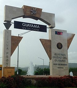 Entering Guayama from PR-54 | |
 Flag  Coat of arms | |
| Nicknames: "La ciudad del Guamaní" Spanish for "The City of the Guamaní" "El pueblo de los brujos" Spanish for "The Witch City" | |
 Map of Puerto Rico highlighting Guayama Municipality | |
| Coordinates: 17°58′27″N 66°06′36″W / 17.97417°N 66.11000°WCoordinates: 17°58′27″N 66°06′36″W / 17.97417°N 66.11000°W[1] | |
| Commonwealth | |
| Founded | January 29, 1736 |
| Barrios | show
10 barrios |
| Government | |
| • Mayor | Eduardo Cintrón (PDP) |
| Area | |
| • Total | 106.8 sq mi (277 km2) |
| • Land | 65.0 sq mi (168 km2) |
| • Water | 41.8 sq mi (108 km2) |
| Elevation | 239 ft (73 m) |
| Population | |
| • Total | 36,614 |
| • Rank | 22nd, PR |
| • Density | 340/sq mi (130/km2) |
| Demonym(s) | Guayameses[4] |
| Time zone | UTC−4 (Atlantic (AST)) |
| ZIP Codes | 00784, 00785 |
| Area code(s) | 787/939 |
| Major routes | |
| GNIS feature ID | 1610860[2] |
| Website | www |

Guayama (Spanish: [ɡwaˈʝama]), officially the Autonomous Municipality of Guayama (Spanish: Municipio Autónomo de Guayama) is a city and municipality on the Caribbean coast of Puerto Rico. As of the 2010 U.S. Census, the city had a population of 45,362. It is the center of the Guayama metropolitan area, which was home to 84,214 in 2010.
History[]
During the early years of the Spanish colonization, the region known today as Guayama was inhabited by Taíno native people. The indigenous population in this area decreased due to slavery and migration to the Lesser Antilles. The following centuries, the region was under attack from the Taíno rebellion, Caribs and pirates. The town was founded on January 29, 1736 as San Antonio de Padua de Guayama by then Spanish Governor , although there is knowledge of it being populated by native people as early as 1567. Guayama took its name from an Indian leader, or cacique who governed the Southeastern region of the Island, the Guamaní cacique and the Guayama cacique. The meaning of the Indian name is "Great Place" (in Spanish Sitio Grande). It was Governor Don Tomás de Abadía who officially declared Guayama a "pueblo" (town) with the name of San Antonio de Padua de Guayama. That same year the Catholic church in town, San Antonio de Padua, was declared a Parish. In 1776, Guayama had 200 houses, the church and a central plaza and the total population was approximately 5,000 villagers. Construction on Guayama's Parroquial church of San Antonio de Padua began in 1827 and was completed 40 years later. In 1828 the construction of the King's House (Casa del Rey) was completed and the church was rebuilt as well. Earlier that year, Guayama was hit by a terrible fire that destroyed 57 houses and 9 huts. Guayama territorial order was altered at different times through the years. Some of the most populated neighborhoods were segregated to form new towns. Patillas was established in 1811 as an independent municipality. In 1831, the territory comprised the neighborhoods: Algarrobos, Ancones, Arroyo, , Guayama Pueblo, Guamaní, Jobos, Machete, and Yaurel. Later, Arroyo was divided into Arroyo Este and Arroyo Oeste and neighborhoods emerged: Pozo Hondo, Palmas de Aguamanil, Caimital, Pitajayas, Cuatro Calles, Sabana Eneas, Palmas, and Salinas. The latter had been segregated from Coamo.
In 1855, Arroyo was separated to become an independent municipality, taking the neighborhoods: Ancones, Arroyo, Yaurel, Pitajaya, and Cuatro Calles. By 1878, Guayama was a department head including: Comerío (then Sabana del Palmar), Cidra, Cayey, Salinas, Arroyo, San Lorenzo (then called Hato Grande), Aguas Buenas, Caguas, Gurabo, and Juncos. The development continued with the construction of the town cemetery in 1844, the slaughterhouse and meat market in 1851, and a wooden theater of two levels in 1878. By then Guayama had fourteen sugar plantations operating with steam engines and three with ox mills. Also practiced in this municipality was the exploitation of lead mines by the company "La Estrella", owned by Miguel Planellas, as well as the mineral galena, by the company "La Rosita", owned by Antonio Aponte. In 1881, Guayama is declared a Villa (First Order Municipality).

During the Spanish–American War, American forces under General Nelson A. Miles landed at Guánica near Ponce on July 25, 1898. The landing surprised the United States War Department no less than the Spanish, as Miles had been instructed to land near San Juan (the War Department learned of the landing through an Associate Press release.) However, en route to Puerto Rico Miles concluded that a San Juan landing was vulnerable to attack by small boats, and so changed plans. Ponce, said at the time to be the largest city in Puerto Rico, was connected with San Juan by a 70-mile military road, well defended by the Spanish at Coamo and Aibonito. In order to flank this position, American Major General John R. Brooke landed at Arroyo, just east of Guayama, intending to move on Cayey, which is northwest of Guayama, along the road from Ponce to San Juan. General Brooke occupied Guayama August 5, 1898, after slight opposition, in the Battle of Guayama. On August 9, the Battle of Guamaní took place north of Guayama. A more significant battle, the Battle of Aibonito Pass, was halted on the morning of August 13 upon notification of the armistice between the United States and Spain.
Puerto Rico was ceded by Spain in the aftermath of the Spanish–American War under the terms of the Treaty of Paris of 1898 and became a territory of the United States. In 1899, the United States conducted its first census of Puerto Rico finding that the population of Guayama was 12,749.[6]
After the Spanish–American War, Guayama continued to develop. The Bernardini Theater built by engineer Manuel Texidor y Alcalá del Olmo opened in 1913. The venue, property of attorney Thomas Bernardini, was the scene for artists of international fame. By that time, Guayama was considered one of the most important cities on the island's social scene.

In the early twentieth century, there were selected societies such as the 'Coliseo Derkes' and 'Grupo Primavera', which endowed performing arts as well as scientific events. By the mid-twentieth century, Guayama achieved great industrial development, especially with the establishment of Univis Optical Corp., Angela Manufacturing Company and a petrochemical complex of the Phillips Petroleum Company. In 1968, the company started production of paraffin, benzene, synthetic fibers, nylon, plastic anhydrous, a million gallons of gasoline a day, and many other products. During that same decade agriculture began to decline as a result of land loss, industrialization and the construction of multiple housing developments. The urban growth affected the sugar cane industry. However, in 1974, 155,595 tons of sugar cane was harvested in the Municipality producing 12,655 tons of refined sugar.[7]
In November 2002, AES Puerto Rico opened its coal power plant in Guayama. The company transmits and distributes electricity through a 25-year contract with the Puerto Rico Electric Power Authority. The 2012 National Puerto Rican Day Parade was dedicated to the Municipality of Guayama and its people.
Geography[]
Guayama is located at 17°58′27″N 66°06′36″W / 17.974241°N 66.110034°W.[1][8]
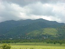
The Municipality of Guayama is located on the Southern Coastal Valley region, bordering the Caribbean Sea, south of Cayey; east of Salinas; and west of Patillas and Arroyo. Guayama's municipal territory reaches the central mountain range to the north and the Caribbean Sea to the south. The mountain systems (2,395 feet or 730 meters) and Sierra de Cayey cover some of the municipality area. The highest points are the Cerro de la Tabla (2,834 feet or 863 meters) and Cerro Tumbado (2,450 feet or 746 meters), which are part of the Sierra de Cayey mountain system. Other elevations are the mountains Garau, Charcas and Peña Hendida. Parts of the Guavate-Carite Forest and the Aguirre State Forest are in Guayama. The Guavate-Carite Forest, a 6,000-acre nature reserve is inhabited by 50 species of birds, making this spot a recognized area for birding and has a reserve with a dwarf forest that was produced by the region's high humidity and moist soil. The Aguirre Forest includes: mangroves, tidal flats, bird rookeries, research lakes & large manatee population. The Jobos Bay National Estuarine Research Reserve was established in 1987. The reserve is located between the coasts of Salinas and Guayama, approximately 2,883 acres of mangrove forest and freshwater wetlands. The two main components: Mar Negro mangrove forest, which consists of a mangrove forest and a complex system of lagoons and channels interspersed with salt and mud flats; and Cayos Caribe Islets, which are surrounded by coral reefs and seagrass beds, with small beach deposits and upland areas.
Hurricane Maria[]
Hurricane Maria on September 20, 2017 triggered numerous landslides in Guayama with the significant amount of rainfall.[9][10] After Hurricane Maria hit Puerto Rico, the people of Guayama had to resort to collecting spring water.[11]
Features[]
- Islands include Cayo Caribes, Isla Morrillito and Mata Redonda.
- Carite Dam
- Gorges; Barros, Branderí, Cimarrona, Corazón, Culebra, Palmas Bajas, and Salada.
- Lakes: Melania Lake, Carite Lake
- Las Mareas Lagoon
- Rivers: Río Chiquito, Río Guamaní, Río de la Plata and Río Seco.
Climate[]
The annual precipitation is approximately 52 inches and the average temperature is 81 °F.
| hideClimate data for Guayama, Puerto Rico (1991–2020 normals, extremes 1914–present) | |||||||||||||
|---|---|---|---|---|---|---|---|---|---|---|---|---|---|
| Month | Jan | Feb | Mar | Apr | May | Jun | Jul | Aug | Sep | Oct | Nov | Dec | Year |
| Record high °F (°C) | 94 (34) |
94 (34) |
95 (35) |
96 (36) |
96 (36) |
95 (35) |
99 (37) |
99 (37) |
98 (37) |
96 (36) |
97 (36) |
95 (35) |
99 (37) |
| Average high °F (°C) | 85.4 (29.7) |
85.5 (29.7) |
85.9 (29.9) |
86.9 (30.5) |
87.9 (31.1) |
88.8 (31.6) |
89.7 (32.1) |
90.0 (32.2) |
90.0 (32.2) |
89.3 (31.8) |
88.1 (31.2) |
86.5 (30.3) |
87.8 (31.0) |
| Daily mean °F (°C) | 78.7 (25.9) |
78.6 (25.9) |
78.9 (26.1) |
80.3 (26.8) |
81.8 (27.7) |
83.0 (28.3) |
83.6 (28.7) |
83.7 (28.7) |
83.4 (28.6) |
82.6 (28.1) |
81.3 (27.4) |
79.8 (26.6) |
81.3 (27.4) |
| Average low °F (°C) | 71.9 (22.2) |
71.7 (22.1) |
71.9 (22.2) |
73.7 (23.2) |
75.7 (24.3) |
77.2 (25.1) |
77.5 (25.3) |
77.4 (25.2) |
76.8 (24.9) |
76.0 (24.4) |
74.6 (23.7) |
73.0 (22.8) |
74.8 (23.8) |
| Record low °F (°C) | 60 (16) |
60 (16) |
61 (16) |
60 (16) |
62 (17) |
64 (18) |
65 (18) |
67 (19) |
65 (18) |
63 (17) |
62 (17) |
62 (17) |
60 (16) |
| Average precipitation inches (mm) | 2.42 (61) |
1.70 (43) |
1.90 (48) |
2.84 (72) |
5.26 (134) |
4.58 (116) |
5.46 (139) |
7.08 (180) |
7.30 (185) |
7.22 (183) |
5.85 (149) |
2.79 (71) |
54.40 (1,382) |
| Average precipitation days (≥ 0.01 in) | 14.5 | 13.1 | 12.0 | 12.5 | 15.9 | 16.6 | 17.2 | 18.5 | 16.0 | 17.5 | 16.2 | 15.1 | 185.1 |
| Source: NOAA[12][13] | |||||||||||||
Barrios[]

Like all municipalities of Puerto Rico, Guayama is subdivided into barrios. The municipal buildings, central square and large Catholic church are located in a barrio referred to as "el pueblo".[14][15][16][17]
Population, per 2010 census: Algarrobo 6,959; Caimital 4,124; Carite 1,210; Carmen 619; Guamaní 1,455 ; Guayama Pueblo 16,891; Jobos 8,286; Machete 3,846; Palmas 709; Pozo Hondo 1,263; Total 45,362[5]
Sectors[]
Barrios (which are like minor civil divisions)[19] and subbarrios,[20] in turn, are further subdivided into smaller local populated place areas/units called sectores (sectors in English). The types of sectores may vary, from normally sector to urbanización to reparto to barriada to residencial, among others.[21][22][23]
Special Communities[]
Comunidades Especiales de Puerto Rico (Special Communities of Puerto Rico) are marginalized communities whose citizens are experiencing a certain amount of social exclusion. A map shows these communities occur in nearly every municipality of the commonwealth. Of the 742 places that were on the list in 2014, the following barrios, communities, sectors, or neighborhoods were in Guayama: Borinquén, Comunidad Mosquito, Comunidad Puerto de Jobos, Loma del Viento, and Pueblito Del Carmen.[24]
Tourism[]
Landmarks and places of interest[]

Guayama has 19 beaches including Playa el Bohío.[25]
Other places of interest in Guayama include:
- San Antonio de Padua Church
- Guayama Town Plaza (Plaza pública Cristobal Colón)
- Molino y Hacienda Azucarera Vives
- Casa Cautiño Museum
- Centro de Bellas Artes
- Teatro Calimano
- First Methodist Church (Built in 1902)
- Guayama Convention Center
- Céntrico Mall [26]
- El Legado Golf Resort
- Mariposario Las Limas Natural Reserve
- Jobos Bay National Estuarine Research Reserve
- Guavate-Carite Forest
- Aguirre State Forest
- Carite Lake
- Pozuelo Beach
- Rodeo Beach
- Fishing Club Guayama
Economy[]
Industry[]
Guayama is home to various pharmaceutical and manufacturing companies, such as Pfizer, Baxter, Eli Lilly, and Tapi. A coal power plant operated by AES and a Phillips Petroleum Company petrochemical complex are also in the area.
Health facilities[]
The San Lucas Episcopal Hospital, located on Pedro Albizu Campos Avenue and operated by the Episcopal Diocese of Puerto Rico and the Santa Rosa Hospital are the main medical facilities in Guayama. The Veterans Health Administration operates a Community-Based Outpatient Clinic (COBC) in the Municipality.
Culture[]
Guayama is the birthplace of numerous artists and musicians who have significantly influenced Puerto Rican culture. During the 20th century, the literary culture of the city was influenced by performers including Afro-Antillano genre poet Luis Palés Matos and his father Vicente Palés Anés. Music composer Catalino "Tite" Curet Alonso who became a composer of over 2,000 salsa songs is also from Guayama, even though he was raised in the Santurce section of San Juan. Other performers born in Guayama include actresses Gilda Galán and Karla Monroig. The Casa Cautiño Museum is administered by the Institute of Puerto Rican Culture and include works of art, wood carvings, sculptures and furniture built by Puerto Rican cabinetmakers for the Cautiño family. The museum is listed on the National Register of Historic Places.
Festivals and events[]
Guayama celebrates its patron saint festival in June. The Fiestas Patronales de San Antonio de Padua is a religious and cultural celebration that generally features parades, games, artisans, amusement rides, regional food, and live entertainment.[8][27]
Other festivals and events celebrated in Guayama include:
- Witches Carnival – March
- Guayama Carnival – April
- Sweet Dreams Fair – March
- Paso Fino Fair – March
- Jíbaro Festival – October
- Puerto Rican Week – December
Sports[]
Guayama had one of the Professional Baseball League founding teams, which won the Championship the first years of the league, 1938–39 and 1939–40. Guayama has a baseball team (Brujos de Guayama) in the Federación de Béisbol Aficionado de Puerto Rico that won the national championship in 1987. Guayama also used to have a basketball team in the Puerto Rico's BSN (Brujos de Guayama) that went to the League finals twice back in 1991 and 1994 but lost both times to eventual champions Atleticos de San German, it was announced that the team will return for the league's 2012 season.[28] The Guayama Convention Center hosted some of the roller skating events for the 2010 Central American and Caribbean Games that took place in Mayagüez, Puerto Rico from July 18, 2010 to August 1, 2010. El Legado Golf Resort, a 285 acres, 18 hole golf course founded in 2002 by Puerto Rican golf player Juan "Chi-Chi" Rodriguez. The Guayama Football Club, founded in 1949, plays in the Liga Puerto Rico.
Demographics[]
| Historical population | |||
|---|---|---|---|
| Census | Pop. | %± | |
| 1900 | 12,749 | — | |
| 1910 | 17,379 | 36.3% | |
| 1920 | 19,192 | 10.4% | |
| 1930 | 23,624 | 23.1% | |
| 1940 | 30,511 | 29.2% | |
| 1950 | 32,807 | 7.5% | |
| 1960 | 33,678 | 2.7% | |
| 1970 | 36,249 | 7.6% | |
| 1980 | 40,183 | 10.9% | |
| 1990 | 41,588 | 3.5% | |
| 2000 | 44,301 | 6.5% | |
| 2010 | 45,362 | 2.4% | |
| 2020 | 36,614 | −19.3% | |
| U.S. Decennial Census[29] 1899 (shown as 1900)[30] 1910-1930[31] 1930-1950[32] 1960-2000[33] 2010[16] 2020[34] | |||
As of the 2020 U.S. Census, the city had a population of 36,614. It is the center of the Guayama metropolitan area, which was home to 84,214 in 2010.
In terms of race and ethnicity, the 2010 U.S. Census stated the following concerning Guayameses:
- White: 72.8% (33,025)
- Black: 22.9% (10,367)
- American Indian/Indigenous: 1.7% (769)
- Asian: 0.2% (108)
- Native Hawaiian/Pacific Islander: 0.1% (51)
- Some Other Race: 8.3.% (3,746)
Government[]
The current mayor of Guayama is Eduardo E. Cintrón Suárez, of the Popular Democratic Party (PPD). He was elected at the 2012 general elections.
The city belongs to the Puerto Rico Senatorial district VI, which is represented by two Senators. In 2012, Miguel Pereira Castillo and Angel M. Rodríguez were elected as District Senators.[35]
Symbols[]
The municipio has an official flag and coat of arms.[36]
Flag[]

The flag of Guayama is made up of three stripes of different colors: black, yellow, and red from top to bottom. The black stands for the enslaved Africans brought to Puerto Rico, many to Guayama. The yellow represents sugar cane industry in Puerto Rico and the significance of Guayama's sugar plantations. The red symbolizes the blood shed by Taíno Indians in their fight against the Spanish/European colonizers. To the left of the top stripe we can see the Old Mill, which today is known as the Molino de Vives.[37]
Coat of arms[]
The shield is divided in four parts and in two of them part of a chessboard appears. The chessboard pattern represents the center of the city, which resembles a chessboard. It has two old mill towers. The laurel trees constitute a representation of the beautiful Recreation Plaza very well known for its trimmed trees. The three silver flowers symbolize San Antonio de Padua, patron of Guayama. The crown represents Cacique Guayama, name of the town. The big crown has four towers.[37]
Education[]
The education system in Guayama has three public high schools, which are Francisco Garcia Boyrie, Adela Brenes Texidor and Dr. Rafael Lopez Landrón, and one vocational high school, Dra. Maria Socorro Lacot. Guayama also has a campus of the Puerto Rico Institute of Technology and the Inter American University of Puerto Rico, Guayama campus (Universidad Interamericana de Puerto Rico, Recinto de Guayama in Spanish) Universidad Interamericana de Puerto Rico – Recinto de Guayama . It also has several private schools such as Academia San Antonio, Guamaní Private School, Saint Patrick's Bilingual School, Colegio Catòlico San Antonio, Fountain Christian Bilingual School, Escuela Superior and Academia Adventista Tres Angeles and more than 12 other public schools in the elementary and intermediate education levels.[38][39][40]
Transportation[]
Guayama has direct access to Puerto Rico Highway 54 which connect with Puerto Rico Highway 52 in the vicinity of Salinas and its downtown/business area is served by Puerto Rico Highways 3, 179, 744, and 748. The Municipality has good paved roads and is only 38 mi (61 km) away from both San Juan and Ponce. The nearest international airport is the Mercedita Airport in Ponce.
At one time during 1937, Guayama received domestic, commercial airline flights from San Juan on Puerto Rico's national airline, Puertorriquena de Aviacion.[41]
There are 28 bridges in Guayama.[42]
Notable people[]
- Jose C. Aponte Garcia - Puerto Rico Prosecuting Attorney during the Administrations of Luis Munoz Marin, Roberto Sanchez Vilella; Secretary of Justice during Roberto Sanchez Vilella's Administration
- - avant-garde music composer, music professor and writer (Las Mieles del Alba, 2015)
- Catalino (Tite) Curet Alonso - composer of over 2,000 salsa songs.
- Diosa Costello - actress, AKA: The Original Latin Bombshell. True Name: Juana de Dios Castrello
- Luis Palés Matos - Puerto Rican poet who is credited with creating the poetry genre known as Afro-Antillano.
- Gilda Galán - Puerto Rican actress, dramaticist, comedian, writer, composer, scriptwriter and poet.[43]
- Rafael Pérez Perry - Businessman and a pioneer in Puerto Rico's radio and television broadcasting industry. In 1954 founded Puerto Rico's television Channel 11 (nowadays Univision Puerto Rico).
- Miguel Poventud - Puerto Rican musician, singer, actor and composer of Boleros.
- Pedro Garcia - MLB player for the Milwaukee Brewers, Detroit Tigers, and the Toronto Blue Jays
- Karla Monroig - Telenovela actress, model and television host.
- Roger Moret- Former Major League Baseball pitcher
- Juan Laporte -Former WBC featherweight boxing champion (1982–1984)
- Jaime Fuster Berlingeri- Associate Justice to the Supreme Court of Puerto Rico and former Resident Commissioner to the U.S. Congress.
- Marcos Crespo - Democratic member of the New York State Assembly representing the 85th Assembly District.
- Carmelo Delgado Delgado - Leader of the Puerto Rican Nationalist Party. Is thought to be the first U.S. citizen to die in Spain's civil war.
- Dr.Victor Manuel Blanco PhD - Scientist and astronomer who in 1959 discovered "Blanco 1," a galactic cluster.
- Eddie Rosario - Major League Baseball player for the Cleveland Indians.
Gallery[]
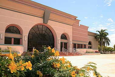
The Guayama Convention Center

Plaza Guayama Mall

The central plaza and church of San Antonio de Padua in Guayama


See also[]
- List of Puerto Ricans
- History of Puerto Rico
- Did you know-Puerto Rico?
References[]
- ^ Jump up to: a b c "US Gazetteer files: 2010, 2000, and 1990". United States Census Bureau. 12 February 2011. Archived from the original on 13 July 2020. Retrieved 23 April 2011.
- ^ Jump up to: a b "US Board on Geographic Names". United States Geological Survey. 25 October 2007. Archived from the original on 26 February 2012. Retrieved 31 January 2008.
- ^ Bureau, US Census. "PUERTO RICO: 2020 Census". The United States Census Bureau. Retrieved 25 August 2021.
- ^ "Nicknames and Demonyms of the Towns of Puerto Rico" Archived 2012-01-05 at the Wayback Machine. (In Spanish). Center of Information Access. Interamerican University of Puerto Rico, Ponce. Retrieved 2012-03-04.
- ^ Jump up to: a b "U.S. Census website". United States Census Bureau. Archived from the original on 27 December 1996. Retrieved 31 January 2008.
- ^ Joseph Prentiss Sanger; Henry Gannett; Walter Francis Willcox (1900). Informe sobre el censo de Puerto Rico, 1899, United States. War Dept. Porto Rico Census Office (in Spanish). Imprenta del gobierno. p. 163. Archived from the original on 15 November 2012. Retrieved 10 March 2020.
- ^ Medina-Carrillo, Norma. "Hacienda Esperanza, Molino Vives, Guayama Puerto Rico" (PDF). aperpuertorico.com. Archived (PDF) from the original on 25 March 2019. Retrieved 31 August 2020.
- ^ Jump up to: a b "Guayama Municipality". Enciclopedia de Puerto Rico. Fundación Puertorriqueña de las Humanidades (FPH). Archived from the original on 1 May 2019. Retrieved 20 March 2019.
- ^ "Preliminary Locations of Landslide Impacts from Hurricane Maria, Puerto Rico". USGS Landslide Hazards Program. USGS. 27 October 2017. Retrieved 17 February 2020.
- ^ "Preliminary Locations of Landslide Impacts from Hurricane Maria, Puerto Rico" (PDF). USGS Landslide Hazards Program. USGS. Archived from the original (PDF) on 3 March 2019. Retrieved 3 March 2019.
- ^ Baez, Alvin (18 October 2017). "The search for water in Puerto Rico". Reuters. Archived from the original on 15 January 2019. Retrieved 15 January 2019.
- ^ "NowData - NOAA Online Weather Data". National Oceanic and Atmospheric Administration. Retrieved 17 June 2021.
- ^ "Station: Guayama 2E, PR PQ". U.S. Climate Normals 2020: U.S. Monthly Climate Normals (1991-2020). National Oceanic and Atmospheric Administration. Retrieved 17 June 2021.
- ^ Picó, Rafael; Buitrago de Santiago, Zayda; Berrios, Hector H. Nueva geografía de Puerto Rico: física, económica, y social, por Rafael Picó. Con la colaboración de Zayda Buitrago de Santiago y Héctor H. Berrios. San Juan Editorial Universitaria, Universidad de Puerto Rico,1969. Archived from the original on 26 December 2018. Retrieved 5 January 2019.
- ^ Gwillim Law (20 May 2015). Administrative Subdivisions of Countries: A Comprehensive World Reference, 1900 through 1998. McFarland. p. 300. ISBN 978-1-4766-0447-3. Retrieved 25 December 2018.
- ^ Jump up to: a b Puerto Rico:2010:population and housing unit counts.pdf (PDF). U.S. Dept. of Commerce Economics and Statistics Administration U.S. Census Bureau. 2010. Archived (PDF) from the original on 20 February 2017. Retrieved 5 January 2019.
- ^ "Map of Guayama" (PDF). Welcome to Puerto Rico. Archived (PDF) from the original on 24 March 2018. Retrieved 29 December 2018.
- ^ "US Census Barrio-Pueblo definition". Fact Finder on US Census. US Census. Archived from the original on 13 May 2017. Retrieved 5 January 2019.
- ^ "US Census Barrio-Pueblo definition". factfinder.com. US Census. Archived from the original on 13 May 2017. Retrieved 5 January 2019.
- ^ "P.L. 94-171 VTD/SLD Reference Map (2010 Census): Guayama Municipio, PR" (PDF). www2.census.gov. U.S. DEPARTMENT OF COMMERCE Economics and Statistics Administration U.S. Census Bureau. Archived (PDF) from the original on 22 August 2020. Retrieved 22 August 2020.
- ^ "Agencia: Oficina del Coordinador General para el Financiamiento Socioeconómico y la Autogestión (Proposed 2016 Budget)". Puerto Rico Budgets (in Spanish). Archived from the original on 28 June 2019. Retrieved 28 June 2019.
- ^ Rivera Quintero, Marcia (2014), El vuelo de la esperanza: Proyecto de las Comunidades Especiales Puerto Rico, 1997-2004 (first ed.), San Juan, Puerto Rico Fundación Sila M. Calderón, ISBN 978-0-9820806-1-0
- ^ "Leyes del 2001". Lex Juris Puerto Rico (in Spanish). Archived from the original on 14 September 2018. Retrieved 24 June 2020.
- ^ Rivera Quintero, Marcia (2014). El vuelo de la esperanza : el Proyecto de las Comunidades Especiales Puerto Rico, 1997-2004 [The flight of hope: the Special Communities Project Puerto Rico, 1997-2004] (in Spanish) (1st ed.). San Juan, Puerto Rico. p. 273. ISBN 978-0-9820806-1-0. OCLC 932293879.
- ^ "Las 1,200 playas de Puerto Rico [The 1200 beaches of Puerto Rico]". Primera Hora (in Spanish). 14 April 2017. Archived from the original on 12 December 2019. Retrieved 12 December 2019.
- ^ Soto, Miladys (13 September 2019). "Plaza Guayama se reinventa y se convierte en Céntrico". Metro. Archived from the original on 26 December 2019. Retrieved 26 December 2019.
- ^ "Puerto Rico Festivales, Eventos y Actividades en Puerto Rico". Puerto Rico Hoteles y Paradores (in Spanish). Archived from the original on 26 February 2020. Retrieved 17 July 2020.
- ^ Proximo juego local vs Quebradillas: 22 de abril de 2012. Accessed on 17 January 2021.
- ^ "U.S. Decennial Census". United States Census Bureau. Archived from the original on 13 February 2020. Retrieved 21 September 2017.
- ^ "Report of the Census of Porto Rico 1899". War Department Office Director Census of Porto Rico. Archived from the original on 16 July 2017. Retrieved 21 September 2017.
- ^ "Table 3-Population of Municipalities: 1930 1920 and 1910" (PDF). United States Census Bureau. Archived (PDF) from the original on 17 August 2017. Retrieved 21 September 2017.
- ^ "Table 4-Area and Population of Municipalities Urban and Rural: 1930 to 1950" (PDF). United States Census Bureau. Archived (PDF) from the original on 30 August 2015. Retrieved 21 September 2014.
- ^ "Table 2 Population and Housing Units: 1960 to 2000" (PDF). United States Census Bureau. Archived (PDF) from the original on 24 July 2017. Retrieved 21 September 2017.
- ^ Bureau, US Census. "PUERTO RICO: 2020 Census". The United States Census Bureau. Retrieved 25 August 2021.
- ^ Elecciones Generales 2012: Escrutinio General Archived 2013-01-15 at the Wayback Machine on CEEPUR
- ^ "Ley Núm. 70 de 2006 -Ley para disponer la oficialidad de la bandera y el escudo de los setenta y ocho (78) municipios". LexJuris de Puerto Rico (in Spanish). Retrieved 15 June 2021.
- ^ Jump up to: a b "GUAYAMA". LexJuris (Leyes y Jurisprudencia) de Puerto Rico (in Spanish). 19 February 2020. Archived from the original on 19 February 2020. Retrieved 17 September 2020.
- ^ Delgado, Joe. "Guayama... El Pueblo de los Brujos". Link to Puerto Rico.com (in Spanish). Archived from the original on 22 December 2007.CS1 maint: unfit URL (link)
- ^ Delgado, Joe. "Guayama... Town Of Wizards". Link to Puerto Rico.com. Translated with assistance from George LaMontagne. Archived from the original on 14 December 2007.CS1 maint: unfit URL (link)
- ^ "ESCUELAS". Salon Hogar (in Spanish). Archived from the original on 17 January 2008. Retrieved 2 January 2008.
- ^ Larsson, Björn; Zekira, David (29 January 2015). "Aerovias NPR - Aerovias Nacionales Puerto Rico". Airline Timetable Images. Archived from the original on 22 August 2020. Retrieved 17 February 2020.
- ^ "Guayama Bridges". National Bridge Inventory Data. US Dept. of Transportation. Archived from the original on 21 February 2019. Retrieved 20 February 2019.
- ^ Rodriguez, Jorge (23 June 2009). "Fallece primera actriz Gilda Galán" [First actress Gilda Galán dies]. El Vocero de Puerto Rico (in Spanish). Archived from the original on 4 July 2009. Retrieved 21 July 2009.
External links[]
- Official page of the Municipality of Guayama (In Spanish)
- Official Tourism Page of Guayama (In Spanish)
- Information about Guayama (In Spanish)
- Historic Places in Puerto Rico and the Virgin Islands, a National Park Service Discover
- Welcome to Puerto Rico! Guayama
| show Places adjacent to Guayama, Puerto Rico |
|---|
| show Authority control |
|---|
- Guayama, Puerto Rico
- Municipalities of Puerto Rico
- Populated coastal places in Puerto Rico
- Populated places established in 1736
- Guayama metropolitan area