Camuy, Puerto Rico
Camuy
Municipio Autónomo de Camuy | |
|---|---|
Town and Municipality | |
 | |
 Flag  Coat of arms | |
| Nicknames: "Ciudad Romántica", "Ciudad de los Areneros", "Ciudad del Sol Taíno, "Valle de las Cavernas" | |
| Anthem: "Pedazo de Borinquen" | |
 Map of Puerto Rico highlighting Camuy Municipality | |
| Coordinates: 18°29′02″N 66°50′42″W / 18.48389°N 66.84500°WCoordinates: 18°29′02″N 66°50′42″W / 18.48389°N 66.84500°W | |
| Commonwealth | |
| Founded | 1807 |
| Barrios | show
13 barrios |
| Government | |
| • Mayor | (PNP) |
| • Senatorial dist. | 3 - Arecibo |
| • Representative dist. | 15 |
| Area | |
| • Total | 61.91 sq mi (160.3 km2) |
| • Land | 46.43 sq mi (120.3 km2) |
| • Water | 15.49 sq mi (40.1 km2) |
| Population (2020)[2] | |
| • Total | 32,827 |
| • Density | 530/sq mi (200/km2) |
| Demonym(s) | Camuyanos |
| Time zone | UTC−4 (AST) |
| ZIP Code | 00627 |
| Area code(s) | 787/939 |
| Major routes | |

Camuy (Spanish pronunciation: [kaˈmuj]) is a town and municipality of Puerto Rico, bordering the Atlantic Ocean, north of Lares and San Sebastián; east of Quebradillas; and west of Hatillo. Camuy is spread over 12 barrios and Camuy Pueblo (the downtown area and the administrative center of the city). The town celebrated its 200th anniversary in 2007.
Camuy is part of the "Porta Atlántico" Tourist Area.
History[]
Camuy, popularly known as Romantic City (la ciudad romántica), was founded in 1807 by Petronila Matos, and formerly part of Arecibo is located in the northwestern coastal region of Puerto Rico, less than 5 minutes west of Hatillo municipality, on PR-2 and PR-119. As early as 1846, Puente Camuy, a bridge over the Camuy River linked Camuy with Hatillo.[3] The name Camuy derives from the Taíno language, although a number of legends give differing explanations for the origin of the name. One such legend claims the name comes from the Taíno word for "sun", another claims derivation from camuy, Taíno for "beautiful scenery", and still another states that Camuy was the name of the Taíno chief Yumac with the letters in reverse order. The "sun" legend is reflected in the coat of arms for the municipality.[4]
Puerto Rico was ceded by Spain in the aftermath of the Spanish–American War and became a territory of the United States. In 1899, the United States conducted its first census of Puerto Rico finding that the population of Camuy was 10,887.[5]
In its beginnings Camuy was integrated into the Partition of San Antonio de la Tuna. The "partitions" were great expanses of land that divided Puerto Rico. This region today is known as Isabela, Puerto Rico. At the time the partition covered the areas between Aguadilla and Arecibo, what is known today as the municipalities of Camuy, Hatillo, Quebradillas, Isabela, Utuado, and San Sebastián.
The population of Camuy was 35,159 at the 2010 census, and it has land area of 46.3 square miles (120 km2). The municipality is part of the San Juan-Caguas-Guaynabo metropolitan area and is a popular suburb. It was named in 2015 by the U.S. Conference of Mayors as one of the most livable cities in the United States.[6]
Hurricane Maria on September 20, 2017 triggered numerous landslides in Camuy with the significant amount of rainfall.[7][8] Electricity was restored to the town center on October 4.[9] However, rural areas remained without electricity until March 2018. There were catastrophic damages in Camuy with around 2000 residences damaged or completely destroyed. The hospital's roof was torn off. The 40 animal husbandry businesses in Camuy, agriculture, and tourism industries suffered heavy losses. One of the main tourist attractions in Puerto Rico located in Camuy, Parque Nacional de las Cavernas del Río Camuy was destroyed,[10] and would remain closed for four years.[11]
Geography[]

Camuy belongs to the zone designated as the plateau of the northwest where the terrain is level and known as the Valley of Quebradillas. It is located in the Northern Karst zone of Puerto Rico. In the interior of the municipality the topography becomes very irregular near Cibao. This strip of land, a zone of wooded hills and depressions, divides Camuy completely into two strips, north and south. The northern strip is known as Lomas de los Puertos.[12]
The Camuy River forms part of the hydrographic system with a length of 24 miles, which at one point becomes a narrow that forms one of the most beautiful cave systems in the world: the Rio Camuy Caverns, first explored in 1958. The Camuy River along with the Caverns are the 3rd largest and longest underground system in the world and the river is one of the few remaining active underground rivers in the Americas, stretching for miles. The also forms part of the system.

Barrios[]
Like all municipalities of Puerto Rico, Camuy is subdivided into barrios. The municipal buildings, central square and large Catholic church are located in a small barrio referred to as "el pueblo", near the center of the municipality.[13][14][15]
Sectors[]
Barrios (which are like minor civil divisions)[16] and subbarrios,[17] in turn, are further subdivided into smaller local populated place areas/units called sectores (sectors in English). The types of sectores may vary, from normally sector to urbanización to reparto to barriada to residencial, among others.[18][19][20]
Special Communities[]
Comunidades Especiales de Puerto Rico (Special Communities of Puerto Rico) are marginalized communities whose citizens are experiencing a certain amount of social exclusion. A map shows these communities occur in nearly every municipality of the commonwealth. Of the 742 places that were on the list in 2014, the following barrios, communities, sectors, or neighborhoods were in Camuy: Comunidad Puertos, Pueblo Norte (Calle Estrella), Pueblo Nuevo, Puente Peña (Maracayo), and Puente Pica.[21][22]
Demographics[]
| Historical population | |||
|---|---|---|---|
| Census | Pop. | %± | |
| 1900 | 10,887 | — | |
| 1910 | 11,342 | 4.2% | |
| 1920 | 14,228 | 25.4% | |
| 1930 | 16,149 | 13.5% | |
| 1940 | 18,922 | 17.2% | |
| 1950 | 20,886 | 10.4% | |
| 1960 | 19,739 | −5.5% | |
| 1970 | 19,922 | 0.9% | |
| 1980 | 24,884 | 24.9% | |
| 1990 | 28,917 | 16.2% | |
| 2000 | 35,244 | 21.9% | |
| 2010 | 35,159 | −0.2% | |
| 2020 | 32,827 | −6.6% | |
| U.S. Decennial Census[23] 1899 (shown as 1900)[24] 1910-1930[25] 1930-1950[26] 1960-2000[27] 2010[28] 2020[29] | |||
Tourism[]
Camuy is known for its Parque de las Cavernas del Río Camuy (Camuy River Cave Park), a large network of natural limestone caves and underground waterways shared with nearby municipalities of Hatillo and Lares. The cave system was first documented in the 1973 book Discovery At The Rio Camuy (ISBN 0-517-50594-0) by Russell and Jeanne Gurnee. The park built around the cave system features tours of some of the caves, and is one of the most popular natural attractions in Puerto Rico. The caverns were created by the Río Camuy (Camuy River), the third longest underground river in the world.[30][31] In recognition of this, the Camuy coat of arms includes a symbol for the underground river.
Landmarks and places of interest[]
There are 9 beaches in Camuy, including Peñón Brussi.[32]

Other places of interest of Camuy include:[30]
- Hacienda Morell
- Peñon Brusi Beach[33]
- Peñon Amador Beach (Home of the Flamingo)
- Rio Camuy Cave Park[34]
- Paseo Tablado del Río Camuy (Boardwalk)
- Ernesto Memorial Chapel[35]
- Camuy History Museum[36]
To stimulate local tourism during the COVID-19 pandemic in Puerto Rico, the Puerto Rico Tourism Company launched the Voy Turistiendo (I'm Touring) campaign in 2021. The campaign featured a passport book with a page for each municipality. The Voy Turisteando Camuy passport page lists Iglesia de Piedra, Balneario Peñon Brusi, and Parque de Las Cavernas del Río Camuy, as places of interest.[37]
Culture[]
Religion[]

Camuy is first and foremost Catholic but there are other religions present in the town, including Protestant denominations such as the Pentecostals, Presbyterians, Methodists, and others. There are four Roman Catholic parishes in Camuy:
- The San Jose Parish named after the patron of the town and located in the town square[3]
- The Miraculous Medal (also known as "El Calvario") in Piedra Gorda
- The Assumption of Mary located in Quebrada
- Our Lady of Montserrate located at Soller near the municipality of Quebradillas
- The Ernesto Memorial Chapel, a Methodist church also known as Iglesia de Piedra (Church of Stone) is famous and on the US National Register of Historic Places, because it was handmade with limestones.
Sports[]
The town has many local sports teams (volleyball, basketball, martial arts, swimming etc.) but most notably are their baseball teams. Many of them are part of the little league and the intermediate system but at the top the two professional Class A and Double AA baseball teams called "Los Arenosos" (Referring to the abundance of sand from the coastline).
Festivals and Events[]
The patron saint of Camuy is Saint Joseph. His day is celebrated on March 1. The patron saint festivities (Fiestas Patronales) are celebrated every year around the last 2 weeks of the month of March, the month of Saint Joseph. His official liturgical day is March 1. Other festivals and celebrations that take place in Camuy include:[30]
- Velorio Tres Reyes Magos or Three Kings Celebration - January
- Mondongazo Festival - February
- Camuy Carnival - February
- Balseada del Río Camuy and 5k Race - March
- Patron Festivities San José - March
- "Reviving Our Traditions Festival" -June
- Peñon Brussi Beach Festival - July
- Municipal Cultural Fair - November[38]
Economy[]
Agriculture[]

Agriculture (sugarcane some time ago) and cattle and milk production.[12]
Business[]
There's an active manufacturing industry in the city, including companies such as Alaska based Cazador Apparel, Seamless Textiles, Hanes, Best Quality Coop and Camuy Furniture Warehouse. SNC Technical Services is another textile manufacturer in Camuy which picked up production in 2019.[39]
In terms of commercial development, several fast foods franchises, banks and stores can be found in Camuy. Two strip malls are also planned to be constructed in the city.
Tourism plays an important role in Camuy's economy due in part to the Rio Camuy Caves, and Camuy's public beaches.[12]
Government[]
All municipalities in Puerto Rico are administered by a mayor, elected every four years. The current mayor of Camuy is Gabriel Hernández Rodríguez, of the New Progressive Party (PNP).[40]
The city belongs to the Puerto Rico Senatorial district III, which is represented by two Senators. In 2008, José Emilio González Velázquez and Angel Martínez Santiago were elected as District Senators.[41]
Transportation[]
In 2019, there were 4 bridges in Camuy.[42]
Symbols[]
The municipio has an official flag and coat of arms.[43]
Flag[]
The flag is green like the coat of arms. A white undulating band runs horizontally across and is interrupted in the middle by the figure of the Camuy sun, in this case represented by the colors yellow and black.[4][44]
Coat of arms[]
The silver-waving stripe symbolizes the Camuy River (interrupted in the center because the river goes underground for part of its trajectory). The three tower crown distinguishes Camuy as a municipality.[4][44]
Education[]
Camuy currently has 17 public schools[45] and a community college.[46]
Gallery[]
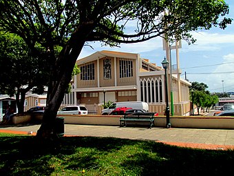
The Camuy parish church in downtown Camuy
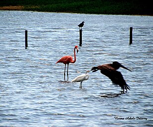
Flamingo and other birds in Yeguada barrio in Camuy


See also[]
References[]
- ^ "Archived copy". Archived from the original on 2020-02-12. Retrieved 2006-07-16.CS1 maint: archived copy as title (link)
- ^ Bureau, US Census. "PUERTO RICO: 2020 Census". The United States Census Bureau. Retrieved 2021-08-25.
- ^ Jump up to: a b Puerto Rico Office of Historian (1949). Tesauro de datos historicos: indice compendioso de la literatura histórica de Puerto Rico, incluyendo algunos datos inéditos, periodísticos y cartográficos (in Spanish). Impr. del Gobierno de Puerto Rico. pp. 13–17. Archived from the original on 22 August 2020. Retrieved 4 January 2020.
- ^ Jump up to: a b c "Camuy Municipality Founding History and Symbols". enciclopediapr.org. Fundación Puertorriqueña de las Humanidades (FPH). Archived from the original on 2018-09-14. Retrieved 14 February 2019.
- ^ Joseph Prentiss Sanger; Henry Gannett; Walter Francis Willcox (1900). Informe sobre el censo de Puerto Rico, 1899, United States. War Dept. Porto Rico Census Office (in Spanish). Imprenta del gobierno. p. 160. Archived from the original on 2012-11-15. Retrieved 2019-02-14.
- ^ "Archived copy". Archived from the original on 2016-06-05. Retrieved 2016-05-16.CS1 maint: archived copy as title (link)
- ^ "Preliminary Locations of Landslide Impacts from Hurricane Maria, Puerto Rico". USGS Landslide Hazards Program. USGS. Archived from the original on 2019-03-03. Retrieved 2019-03-03.
- ^ "Preliminary Locations of Landslide Impacts from Hurricane Maria, Puerto Rico" (PDF). USGS Landslide Hazards Program. USGS. Archived (PDF) from the original on 2019-03-03. Retrieved 2019-03-03.
- ^ "Fiesta anoche en Camuy porque llegó la luz al casco urbano" [Party last night in Camuy because power returned to the urban area]. Primera Hora (Puerto Rico) (in Spanish). 2017-10-04. Retrieved 2021-06-21.
- ^ "María, un nombre que no vamos a olvidar - Camuy" [Maria, a name we will never forget - Camuy]. El Nuevo Día (in Spanish). 2019-06-13. Retrieved 2021-08-24.
- ^ "Encaminan reapertura de las Cavernas de Camuy". El Nuevo Día (in Spanish). 2020-10-27. Retrieved 2021-02-04.
- ^ Jump up to: a b c "Camuy Municipality General Info (Location, Square Miles, Economy and Geography)". enciclopediapr.org. Fundación Puertorriqueña de las Humanidades (FPH). Archived from the original on 2018-09-14. Retrieved 14 February 2019.
- ^ Gwillim Law (20 May 2015). Administrative Subdivisions of Countries: A Comprehensive World Reference, 1900 through 1998. McFarland. p. 300. ISBN 978-1-4766-0447-3. Retrieved 25 December 2018.
- ^ Puerto Rico:2010:population and housing unit counts.pdf (PDF). U.S. Dept. of Commerce, Economics and Statistics Administration, U.S. Census Bureau. 2010. Archived (PDF) from the original on 2017-02-20. Retrieved 2018-12-28.
- ^ "Map of Camuy" (PDF). Archived (PDF) from the original on 2011-06-08. Retrieved 2018-12-28.
- ^ Jump up to: a b "US Census Barrio-Pueblo definition". factfinder.com. US Census. Archived from the original on 13 May 2017. Retrieved 5 January 2019.
- ^ "P.L. 94-171 VTD/SLD Reference Map (2010 Census): Camuy Municipio, PR" (PDF). www2.census.gov. U.S. DEPARTMENT OF COMMERCE Economics and Statistics Administration U.S. Census Bureau. Archived (PDF) from the original on 22 August 2020. Retrieved 22 August 2020.
- ^ "Agencia: Oficina del Coordinador General para el Financiamiento Socioeconómico y la Autogestión (Proposed 2016 Budget)". Puerto Rico Budgets (in Spanish). Archived from the original on 28 June 2019. Retrieved 28 June 2019.
- ^ Rivera Quintero, Marcia (2014), El vuelo de la esperanza: Proyecto de las Comunidades Especiales Puerto Rico, 1997-2004 (first ed.), San Juan, Puerto Rico Fundación Sila M. Calderón, ISBN 978-0-9820806-1-0
- ^ "Leyes del 2001". Lex Juris Puerto Rico (in Spanish). Archived from the original on 14 September 2018. Retrieved 24 June 2020.
- ^ Rivera Quintero, Marcia (2014), El vuelo de la esperanza:Proyecto de las Comunidades Especiales Puerto Rico, 1997-2004 (Primera edición ed.), San Juan, Puerto Rico Fundación Sila M. Calderón, p. 273, ISBN 978-0-9820806-1-0
- ^ "Comunidades Especiales de Puerto Rico" (in Spanish). 8 August 2011. Archived from the original on 24 June 2019. Retrieved 24 June 2019.
- ^ "U.S. Decennial Census". United States Census Bureau. Archived from the original on April 26, 2015. Retrieved September 21, 2017.
- ^ "Report of the Census of Porto Rico 1899". War Department Office Director Census of Porto Rico. Archived from the original on July 16, 2017. Retrieved September 21, 2017.
- ^ "Table 3-Population of Municipalities: 1930 1920 and 1910" (PDF). United States Census Bureau. Archived (PDF) from the original on August 17, 2017. Retrieved September 21, 2017.
- ^ "Table 4-Area and Population of Municipalities Urban and Rural: 1930 to 1950" (PDF). United States Census Bureau. Archived (PDF) from the original on August 30, 2015. Retrieved September 21, 2014.
- ^ "Table 2 Population and Housing Units: 1960 to 2000" (PDF). United States Census Bureau. Archived (PDF) from the original on July 24, 2017. Retrieved September 21, 2017.
- ^ Puerto Rico:2010:population and housing unit counts.pdf (PDF). U.S. Dept. of Commerce Economics and Statistics Administration U.S. Census Bureau. 2010. Archived (PDF) from the original on 2017-02-20. Retrieved 2018-12-28.
- ^ Bureau, US Census. "PUERTO RICO: 2020 Census". The United States Census Bureau. Retrieved 2021-08-25.
- ^ Jump up to: a b c "Camuy Municipality Festivals, Places, Mayor". enciclopediapr.org. Fundación Puertorriqueña de las Humanidades (FPH). Archived from the original on 2018-09-14. Retrieved 14 February 2019.
- ^ "Archived copy". Archived from the original on 2009-06-08. Retrieved 2010-02-24.CS1 maint: archived copy as title (link)
- ^ "Las 1,200 playas de Puerto Rico [The 1200 beaches of Puerto Rico]". Primera Hora (in Spanish). April 14, 2017. Archived from the original on December 12, 2019. Retrieved December 12, 2019.
- ^ Cruz Ríos, Melissa (2021-03-20). "Tiene que conocer estas bellezas de Camuy" [You must know these wonders of Camuy]. El Vocero (in Spanish). Retrieved 2021-06-21.
- ^ "Multi aventuras en Camuy" [Multi adventures in Camuy]. El Vocero. Retrieved 2021-06-21.
- ^ "Iglesia Cristiana Avivamiento La Piedra (The Stone Church)". Atlas Obscura. Archived from the original on 18 June 2019. Retrieved 15 June 2019.
- ^ "La historia del pueblo de Camuy en un solo espacio" [The history of the town of Camuy all in one space]. Primera Hora (Puerto Rico) (in Spanish). 2012-06-11. Retrieved 2021-06-21.
- ^ Pasaporte: Voy Turisteando (in Spanish). Compañia de Turismo de Puerto Rico. 2021.
- ^ "Archived copy". Archived from the original on 2010-08-04. Retrieved 2010-06-12.CS1 maint: archived copy as title (link)
- ^ "Reactivan la industria textil de Puerto Rico". El Nuevo Dia (in Spanish). 10 June 2019. Archived from the original on 10 June 2019. Retrieved 10 June 2019.
- ^ "Camuy anuncia medidas preventivas ante el coronavirus". Primera Hora (in Spanish). 12 March 2020. Archived from the original on 4 June 2020. Retrieved 4 June 2020.
- ^ Elecciones Generales 2008: Escrutinio General Archived November 20, 2011, at the Wayback Machine on CEEPUR
- ^ "Camuy Bridges". National Bridge Inventory Data. US Dept. of Transportation. Archived from the original on 20 February 2019. Retrieved 19 February 2019.
- ^ "Ley Núm. 70 de 2006 -Ley para disponer la oficialidad de la bandera y el escudo de los setenta y ocho (78) municipios". LexJuris de Puerto Rico (in Spanish). Retrieved 2021-06-15.
- ^ Jump up to: a b "CAMUY". LexJuris (Leyes y Jurisprudencia) de Puerto Rico (in Spanish). 19 February 2020. Archived from the original on 19 February 2020. Retrieved 16 September 2020.
- ^ "P.R. Public Schools Directory". escuelasdepr.com (in Spanish). Archived from the original on 28 January 2019. Retrieved 14 February 2019.
- ^ "Universal Technology College of Puerto Rico". UNITEC. Archived from the original on 2018-12-28. Retrieved 2019-03-02.
Further reading[]
- Discovery at the Rio Camuy (amazon link) by Russell & Jeanne Gurnee
- El Solar Morell de Camuy: Sus Ascendientes y Descendientes (amazon link) by P.A. Morell Muñoz
External links[]
 Media from Wikimedia Commons
 Travel guides from Wikivoyage
 Data from Wikidata
| show Places adjacent to Camuy, Puerto Rico |
|---|
- Camuy, Puerto Rico
- Municipalities of Puerto Rico
- Populated coastal places in Puerto Rico
- San Juan–Caguas–Guaynabo metropolitan area
- Populated places established in 1807
- 1807 establishments in Puerto Rico