San Sebastián, Puerto Rico
San Sebastián
Municipio Autónomo de San Sebastián | |
|---|---|
City and Municipality | |
 Neighborhood in San Sebastián | |
 Flag  Coat of arms | |
| Nicknames: "San Sebastián Del Pepino", "Pepino", "Cuna de la Hamaca", "Los Patrulleros" | |
| Anthem: "Van más de dos siglos de historia de vida" | |
 Map of Puerto Rico highlighting San Sebastián Municipality | |
| Coordinates: 18°20′14″N 66°59′26″W / 18.33722°N 66.99056°WCoordinates: 18°20′14″N 66°59′26″W / 18.33722°N 66.99056°W | |
| Commonwealth | |
| Founded | 1752 |
| Barrios | show
24 barrios |
| Government | |
| • Mayor | Javier Jiménez (PNP) |
| • Senatorial dist. | 4 - Mayagüez |
| Area | |
| • Total | 71.7 sq mi (185.77 km2) |
| • Land | 71.4 sq mi (185.0 km2) |
| • Water | 0.3 sq mi (0.77 km2) |
| Population (2020)[1] | |
| • Total | 39,345 |
| • Density | 550/sq mi (210/km2) |
| Demonym(s) | Pepinianos |
| Time zone | UTC−4 (AST) |
| ZIP Code | 00685 |
| Area code(s) | 787/939 |
| Major routes | |
| Website | ssdelpepino |

San Sebastián (Spanish pronunciation: [san seβasˈtjan]) is a town and municipality of Puerto Rico located in the northwestern region of the island, south of Isabela, Quebradillas and Camuy; north of Las Marías; east of Moca and Añasco; and west of Lares. San Sebastián is spread over twenty-four barrios and San Sebastián Pueblo (the downtown area and the administrative center of the city). It is a principal city of the Aguadilla-Isabela-San Sebastián Metropolitan Statistical Area.
History[]

The permission to found the town was officially granted in 1752, under the leadship of the founder, Captain , who among other residents had an interest in converting some cow farms into an agricultural village. The foundation of the town from the religious aspect, was consummated in December 1762 by Mariano Martin, the island catholic bishop at that time. At the beginning, by 1700, San Sebastián was a conglomerate of a few cow farms, owned by some residents of the Partido de Aguada. Las Vegas was the former plain site of one of the first cow farms located by the Guatemala riverside at the north. Also, another of those cow farms was Pepinito (today's downtown) that was a prominent hill with a white calcium carbonate face. On the north side of the town it can be seen some of this pepinos (cucumbers). These two cow farms gave the town its first name. From these geographical features come the first names of the new village: Las Vegas del Pepino (Cucumber Fields). In 1865 it is documented as San Sebastián de Las Vegas del Pepino.
At the beginning of the 19th century, wealthy Spanish families arrived in El Pepino, fleeing the revolutions of Venezuela and the Dominican Republic. Later, by 1850, several families from Catalonia and the Basque Country in Spain joined the large number of isleños (Canary Islanders) that had made El Pepino their home. These people, after taking over the local political power, developed a coffee industry and brought some material progress to the town. Basques in the municipality, in remembrance of their home region and its religious patron, saw the need of updating old traditions used by the Canary Islanders and started to call the town San Sebastián, and thus got the name formally changed by the central government authority. Nevertheless, the citizens of San Sebastián are popularly called pepinianos.
San Sebastián Mártir (Spanish for Saint Sebastian the Martyr) is the patron saint of archers and was chosen to be the patron saint of the town since its early history, first brought by the immigrants from the Canaries and later confirmed by the Basques, with the town name changed in 1869.
Hurricane Maria[]
Hurricane Maria on September 20, 2017 triggered numerous landslides in San Sebastián with the significant amount of rainfall. The hurricane winds knocked all the power out and the town was left in the dark.[2][3]
The 40,000 residents of San Sebastián were left without electrical power.[4] Two weeks after the hurricane decimated the island, Javier Jiménez, the mayor at the time, noticed that help was not on the way. He decided that San Sebastián would not wait for the AEE brigades to come. He assembled an ad hoc team of volunteers, some who were retired AEE electricians, set safety protocols, and their mandate was to get the electrical power back up and running for the people of San Sebastián. Four months after the hurricane, they had restored power to 2,500 homes and continued to do about 60 homes each day.[5] A monument honoring the accomplishments of the Pepino Power Authority, as they were quickly named, was erected in Plaza de la Identidad Pepiniana in San Sebastián barrio-pueblo.[6]
Geography[]
San Sebastián is on the northwest.[7]
Water features[]
- Guajataca Lake
- Río Grande de Añasco
- Río Culebrinas
- Río Guajataca[8]
Barrios[]

Like all municipalities of Puerto Rico, San Sebastián is subdivided into barrios. The municipal buildings, central square and large Catholic church are located in a barrio referred to as "el pueblo".[9][10][11][12]
Sectors[]
Barrios (which are like minor civil divisions)[13] in turn are further subdivided into smaller local populated place areas/units called sectores (which means sectors in English). The types of sectores may vary, from normally sector to urbanización to reparto to barriada to residencial, among others.[14]
Special Communities[]
Comunidades Especiales de Puerto Rico (Special Communities of Puerto Rico) are marginalized communities whose citizens are experiencing a certain amount of social exclusion. A map shows these communities occur in nearly every municipality of the commonwealth. Of the 742 places that were on the list in 2014, the following barrios, communities, sectors, or neighborhoods were in San Sebastián: Guació barrio, Boquerón, Chinto Rodón, Estalingrado, Paralelo 38, Parcelas Perchas II, Pueblo Nuevo, and Tablas Astilla.[15]
Demographics[]
| Historical population | |||
|---|---|---|---|
| Census | Pop. | %± | |
| 1900 | 16,412 | — | |
| 1910 | 18,904 | 15.2% | |
| 1920 | 22,049 | 16.6% | |
| 1930 | 25,691 | 16.5% | |
| 1940 | 30,266 | 17.8% | |
| 1950 | 35,376 | 16.9% | |
| 1960 | 33,451 | −5.4% | |
| 1970 | 30,157 | −9.8% | |
| 1980 | 35,690 | 18.3% | |
| 1990 | 38,799 | 8.7% | |
| 2000 | 44,204 | 13.9% | |
| 2010 | 42,430 | −4.0% | |
| 2020 | 39,345 | −7.3% | |
| U.S. Decennial Census[16] 1899 (shown as 1900)[17] 1910-1930[18] 1930-1950[19] 1960-2000[20] 2010[11] 2020[21] | |||
Tourism[]
Landmarks and places of interest[]
Established in 2016 is the Veredas Sports Complex in barrio Guatemala. The complex which consists of a modern skate park, a sand volleyball court, a zipline with four stations, a climbing and rappelling wall, an outdoor gym, a rope bridge, basketball and tennis courts, and walking paths, is set within an urban forest of about six thousand trees. Hacienda La Fe, an agriculture museum is located at the complex.[22] Other landmarks and places of interest in this municipality include:[23]

The Robles Waterfall (located within the waterfalls zone) - It is a favorite with the locals however, several deaths have occurred at Gozalandia, including tourists[24][25][26]
Church of Saint Sebastian the Martyr on the US National Register of Historic Places, is located in the Pueblo of San Sebastián.
There is a farmer's market held every Friday at the Centro Agropecuario that sells local agriculture as well as souvenirs, for tourists.[27]

The Casa de Doña Bisa Museum located across from the main square in downtown features information on what life was like in the early 20th century.[28]
Other sites include:
- Guajataca Lake
- Collazo Waterfall
- Hacienda El Jibarito
- Hacienda La Fe
- Guajataca Scout Reservation
Economy[]
Agriculture[]

San Sebastián is a producer of coffee, fruits, and has dairy farms.[23] There is a coffee production plant called El Coquí located in Perchas 1, a barrio of San Sebastián.[29]
Government[]
Like all municipalities in Puerto Rico, San Sebastián is administered by a mayor. The current mayor is Javier Jiménez, from the New Progressive Party (PNP). Jiménez was elected at the 2004 general election.
The city belongs to the Puerto Rico Senatorial district IV, which is represented by two Senators. In 2012, María Teresa González and Gilberto Rodríguez were elected as District Senators.[30]
Transportation[]
There are 30 bridges in San Sebastian.[31]
There is also an air strip in San Sebastian, near Culebrinas River, which is visible on Google Earth.[32]
Culture[]
In the town is a Fine Arts and Convention Center called Centro de Convenciones y Bellas Artes, which was in the last phase of its construction, as of February, 2019.[33]
Festivals and events[]

San Sebastián celebrates its patron saint festival in January. The Fiestas Patronales de San Sebastián is a religious and cultural celebration that generally features parades, games, artisans, amusement rides, regional food, and live entertainment.[7][34]
The (Festival de la Novilla), celebrated every year on the first Sunday during the patron saint festival, is San Sebastián's largest festival attracting thousands of people. The celebration features carnival rides, the diverse music of Puerto Rico, cows decorated with flowers, floats and Puerto Rican cuisine. In January 2016, the town celebrated its 40th Heifer festival.[35][36]
Other festivals and events celebrated in San Sebastián include:
- Three Kings Day Festival – January
- Children's Festival – January
- Hammock Festival – July
- Lighting of the Christmas tree – November
- Cultural Evenings – third Thursday of the month
- Farmers' market – every Friday
Sports[]

The Luis Aymat Cardona Coliseum is where the Los Caribes volleyball team plays their games.
In amateur baseball or Double AA baseball, the city is represented by the Patrulleros de San Sebastián, who play at the Juan Jose "Titi" Beniquez Stadium[37] and became champions of the Northwest area in 2019.[38]
Symbols[]
The municipio has an official flag and coat of arms.[39]
Flag[]
It consists of a rectangular flag of the usual proportions, crossed by a white waved band that separates its red superior part from the inferior one, which is green.[40]
Coat of arms[]
The Mountains: With silver-plated borders, represent the characteristic mountains under which the vegetable namesake of the town grow (cucumbers) The Crown: Is the heraldic standard used to identify towns, villas and cities. The sugar cane and coffee ranches represent main agricultural products.[41][40]
Notable people from San Sebastián[]
- Juan Beníquez, a former center fielder in Major League Baseball
- Ángel Mislan, (1862-1911) musician and composer of danzas "Sara" and "Tu y Yo".
- Nilita Vientós Gastón, (1903-1989) an educator, writer and journalist and the first woman president of the Puerto Rican Athenaeum.
- Luis V. Gutiérrez, first Latino to be elected to Congress from the Midwest.
- , first Latino to run for mayor of Albany, NY.
- , contestant on the second season of Idol Puerto Rico.
- Oscar Lopez Rivera, political prisoner.
- , Co-Founder of the 'La Fogata Restaurant' franchise in Houston, Texas.
- Andrés Méndez Liciaga, made the Boceto Histórico Del Pepino
- Walter Cardona, wrote San Sebastián Del Pepino, Notas Para Su Historia
- , La Fundación De Las Vegas Del Pepino and La Formación De La Etnia Cultural Pepiniana
- , Singer
- , Singer/Announcer
- , Singer[42]
- Pedro J. Toro, Singer/Manager
- Altemio Sanchez, Rapist and Serial Killer
- , Singer/also did Theater
- , Singer/Announcer
- , Singer
- , Singer/Actress
- , Opera Singer
- Luz Odilia Font, Telenovela, theater and film actress
- Estefania Soto Torres, Miss Universe Puerto Rico 2020
Gallery[]

Plaza de la Identidad Pepiniana

Centro de Bellas Artes

Pepino Power Authority in Plaza de la Identidad Pepiniana

Monument honoring Pepino Power Authority in Plaza de la Identidad
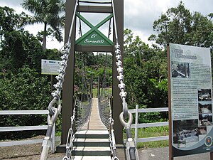
Rope bridge at Veredas Complejo Deportivo
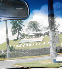
Welcome to San Sebastián sign

The Hacienda La Fe museum is at the Veredas Sports Complex
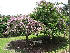
Trees at Veredas Complejo


See also[]
- List of Puerto Ricans
- History of Puerto Rico
- Did you know-Puerto Rico?
References[]
- ^ Bureau, US Census. "PUERTO RICO: 2020 Census". The United States Census Bureau. Retrieved 2021-08-25.
- ^ "Preliminary Locations of Landslide Impacts from Hurricane Maria, Puerto Rico". USGS Landslide Hazards Program. USGS. Archived from the original on 2019-03-03. Retrieved 2019-03-03.
- ^ "Preliminary Locations of Landslide Impacts from Hurricane Maria, Puerto Rico" (PDF). USGS Landslide Hazards Program. USGS. Archived (PDF) from the original on 2019-03-03. Retrieved 2019-03-03.
- ^ Alarcón, Daniel (23 August 2018). "What Happened in the Dark: Puerto Rico's Year of Fighting for Power". Wired. Archived from the original on 4 April 2019. Retrieved 5 June 2019.
- ^ "After Months Without Power, A Puerto Rico Town Strings Its Own Lines". NPR.org. Archived from the original on 2019-06-05. Retrieved 2019-06-05.
- ^ "Pepino Power Authority es una iniciativa de pueblo". El Nuevo Dia (in Spanish). 29 December 2017. Archived from the original on 8 May 2019. Retrieved 8 May 2019.
- ^ Jump up to: a b "San Sebastián Municipality". enciclopediapr.org. Fundación Puertorriqueña de las Humanidades (FPH). Archived from the original on 2019-04-18. Retrieved 2019-03-20.
- ^ "San Sebastian". Puerto_rico9.tripod.com. Archived from the original on 2012-03-06. Retrieved 2012-04-29.
- ^ Picó, Rafael; Buitrago de Santiago, Zayda; Berrios, Hector H. Nueva geografía de Puerto Rico: física, económica, y social, por Rafael Picó. Con la colaboración de Zayda Buitrago de Santiago y Héctor H. Berrios. San Juan Editorial Universitaria, Universidad de Puerto Rico,1969. Archived from the original on 2018-12-26. Retrieved 2018-12-30.
- ^ Gwillim Law (20 May 2015). Administrative Subdivisions of Countries: A Comprehensive World Reference, 1900 through 1998. McFarland. p. 300. ISBN 978-1-4766-0447-3. Retrieved 25 December 2018.
- ^ Jump up to: a b Puerto Rico:2010:population and housing unit counts.pdf (PDF). U.S. Dept. of Commerce Economics and Statistics Administration U.S. Census Bureau. 2010. Archived (PDF) from the original on 2017-02-20. Retrieved 2018-12-26.
- ^ "Map of San Sebastián at the Wayback Machine" (PDF). Archived from the original (PDF) on 2018-03-24. Retrieved 2018-12-29.
- ^ "US Census Barrio-Pueblo definition". factfinder.com. US Census. Archived from the original on 13 May 2017. Retrieved 5 January 2019.
- ^ "PRECINTO ELECTORAL SAN SEBASTIÁN 033" (PDF). Comisión Estatal de Elecciones (in Spanish). PR Government. 19 October 2018. Retrieved 19 June 2019.
- ^ Rivera Quintero, Marcia (2014), El vuelo de la esperanza:Proyecto de las Comunidades Especiales Puerto Rico, 1997-2004 (Primera edición ed.), San Juan, Puerto Rico Fundación Sila M. Calderón, p. 273, ISBN 978-0-9820806-1-0
- ^ "U.S. Decennial Census". United States Census Bureau. Archived from the original on February 13, 2020. Retrieved September 21, 2017.
- ^ "Report of the Census of Porto Rico 1899". War Department Office Director Census of Porto Rico. Archived from the original on July 16, 2017. Retrieved September 21, 2017.
- ^ "Table 3-Population of Municipalities: 1930 1920 and 1910" (PDF). United States Census Bureau. Archived (PDF) from the original on August 17, 2017. Retrieved September 21, 2017.
- ^ "Table 4-Area and Population of Municipalities Urban and Rural: 1930 to 1950" (PDF). United States Census Bureau. Archived (PDF) from the original on August 30, 2015. Retrieved September 21, 2014.
- ^ "Table 2 Population and Housing Units: 1960 to 2000" (PDF). United States Census Bureau. Archived (PDF) from the original on July 24, 2017. Retrieved September 21, 2017.
- ^ Bureau, US Census. "PUERTO RICO: 2020 Census". The United States Census Bureau. Retrieved 2021-08-25.
- ^ "¡Qué muchas atracciones en San Sebastián del Pepino!". Primera Hora (in Spanish). 11 June 2013. Archived from the original on 27 May 2019. Retrieved 27 May 2019.
- ^ Jump up to: a b "Municipio De San Sebastián". Enciclopedia PR (in Spanish). Archived from the original on 21 January 2019. Retrieved 20 January 2019.
- ^ "Archived copy". Archived from the original on 2019-07-31. Retrieved 2019-07-31.CS1 maint: archived copy as title (link)
- ^ "Archived copy". Archived from the original on 2019-07-31. Retrieved 2019-07-31.CS1 maint: archived copy as title (link)
- ^ "Archived copy". Archived from the original on 2019-07-31. Retrieved 2019-07-31.CS1 maint: archived copy as title (link)
- ^ "Experience the San Sebastian Market". Puerto Rico Day Trips. Retrieved 15 June 2020.
- ^ "Museo Historia Casa Doña Bisa". Discover Puerto Rico. Retrieved 2021-09-01.
- ^ "Cafe El Coqui". cafe-elcoqui. Archived from the original on 2018-11-18. Retrieved 2019-01-20.
- ^ Elecciones Generales 2012: Escrutinio General Archived 2013-01-15 at the Wayback Machine on CEEPUR
- ^ "San Sebastian Bridges". National Bridge Inventory Data. US Dept. of Transportation. Archived from the original on 20 February 2019. Retrieved 19 February 2019.
- ^ https://earth.google.com/web/@18.34485135,-67.00971909,53.56675385a,999.9799094d,35y,24.62611168h,60.00623037t,0r
- ^ González, Jennifer. "Gobernador supervisa proyectos en desarrollo en San Sebastián". Metro (in Spanish). Archived from the original on 2019-05-11. Retrieved 2019-05-11.
- ^ J.D. (2006-05-02). "San Sebastián". Link To Puerto Rico.com (in Spanish). Retrieved 2020-07-18.
- ^ Banuchi, Rebecca (17 January 2016). "El pueblo de San Sebastián celebra el Festival de la Novilla". El Nuevo Dia (in Spanish). Retrieved 14 June 2020.
- ^ "Annual Festivals in Puerto Rico". Discover Puerto Rico. Retrieved 14 June 2020.
- ^ "San Sebastián consigue su boleto a la postemporada de la Doble A". Primera Hora (in Spanish). 25 April 2019. Archived from the original on 8 June 2019. Retrieved 8 June 2019.
- ^ "San Sebastián avanza por primera vez desde 2013 al Carnaval de Campeones" (in Spanish). June 23, 2019.
- ^ "Ley Núm. 70 de 2006 -Ley para disponer la oficialidad de la bandera y el escudo de los setenta y ocho (78) municipios". LexJuris de Puerto Rico (in Spanish). Retrieved 2021-06-15.
- ^ Jump up to: a b "SAN SEBASTIAN". LexJuris (Leyes y Jurisprudencia) de Puerto Rico (in Spanish). 19 February 2020. Archived from the original on 19 February 2020. Retrieved 17 September 2020.
- ^ I.C.P. San Sebastián del Pepino: Un inventario de sus recursos culturales. Arcelay Medina,Rubén. Diccionario Biográfico Pepiniano
- ^ "El lechón le dijo al pavo una vez" (in Spanish). November 22, 2012 – via YouTube.
External links[]
- San Sebastián and its barrios, United States Census Bureau
- Puerto Rico Government Directory - San Sebastián
- San Sebastian Official Municipality page on Facebook
- Discover Puerto Rico - San Sebastián
| show Places adjacent to San Sebastián, Puerto Rico |
|---|
| show Authority control |
|---|
- San Sebastián, Puerto Rico
- Municipalities of Puerto Rico
- Aguadilla–Isabela–San Sebastián metropolitan area
- Populated places established in 1752
- 1752 establishments in the Spanish West Indies
- 1750s in Puerto Rico