Fajardo, Puerto Rico
Fajardo
Municipio Autónomo de Fajardo | |
|---|---|
Town and Municipality | |
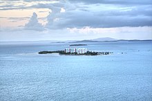
 Aerial view of Fajardo's basin | |
 Flag  Coat of arms | |
| Nicknames: "Los Cariduros", "La Metrópolis del Sol Naciente" | |
| Anthem: "Fajardo que aquí en el oriente" | |
 Map of Puerto Rico highlighting Fajardo Municipality | |
| Coordinates: 18°19′33″N 65°39′09″W / 18.32583°N 65.65250°WCoordinates: 18°19′33″N 65°39′09″W / 18.32583°N 65.65250°W | |
| Commonwealth | |
| Founded | 1772 |
| Barrios | show
9 barrios |
| Government | |
| • Mayor | (PNP) |
| • Senatorial dist. | 8 - Carolina |
| • Representative dist. | 36 |
| Area | |
| • Total | 60.41 sq mi (156.45 km2) |
| • Land | 31 sq mi (81 km2) |
| • Water | 29.13 sq mi (75.45 km2) |
| Population (2020)[1] | |
| • Total | 32,124 |
| • Density | 530/sq mi (210/km2) |
| Demonym(s) | Fajardeños |
| Time zone | UTC−4 (AST) |
| ZIP Codes | 00738, 00740 |
| Area code(s) | 787/939 |
| Major routes | |
| Website | fajardopr |

Fajardo (Spanish pronunciation: [faˈxaɾðo]) is a town and municipality in Puerto Rico located in the east region of the island, facing the Atlantic Ocean, north of Ceiba and east of Luquillo. Fajardo is spread over 7 barrios and Downtown Fajardo (commonly called by the locals Fajardo Pueblo), which serves as the administrative center. It is both a principal part of the Fajardo Metropolitan Statistical Area and the San Juan-Caguas-Fajardo Combined Statistical Area.
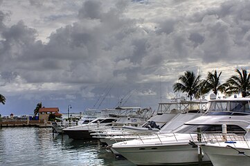
Fajardo is the hub of much of the recreational boating in Puerto Rico and a popular launching port to Culebra, Vieques, and the U.S. and British Virgin Islands. It is also home to the largest marina in the Caribbean, called Puerto del Rey. The town contains various hotels and inns.
Off shore, near Fajardo, a few islets can be found. These are Icacos, , Palominito, and Diablo, among other uninhabited coral islands and barrier reefs.
History[]
Fajardo was founded in 1760, 1773 or 1774 (depending on the authority) as Santiago de Fajardo. It was one of the locations used by the American troops to invade Puerto Rico. On August 1, 1898 the USS Puritan under the command of Captain Frederic W. Rodgers, was sailing by the coastline of the city of Fajardo, when Rogers noticed the Faro de Las Cabezas de San Juan (Cape San Juan lighthouse) which was supposed to be the landing site for the US Army in Puerto Rico. Rodgers ordered some of his men ashore, which included Puerto Rican volunteers, with the mission of posting the American flag atop the lighthouse.
Puerto Rico was ceded by Spain in the aftermath of the Spanish–American War under the terms of the Treaty of Paris of 1898 and became a territory of the United States. In 1899, the United States conducted its first census of Puerto Rico finding that the population of Fajardo was 16,782.[2]
Geography[]
Fajardo is a coastal municipality with a number of islets.[3]
- Fajardo River
- Aguas Buenas Gorge, Fajardo Gorge, Juan Diego Gorge and the Mata Redonda Gorge
- Aguas Prietas and Grande lagoons
Hurricane Maria[]
Hurricane Maria on September 20, 2017 triggered numerous landslides in Fajardo with the significant amount of rainfall.[4][5]
Barrios[]

Like all municipalities of Puerto Rico, Fajardo is subdivided into barrios. The municipal buildings, central square and large Catholic church are located in a barrio referred to as "el pueblo".[6][7][8][9]
Sectors[]
Barrios (which are like minor civil divisions)[10] and subbarrios,[11][12][13] in turn, are further subdivided into smaller local populated place areas/units called sectores (sectors in English). The types of sectores may vary, from normally sector to urbanización to reparto to barriada to residencial, among others.[14][15][16]
Special Communities[]
Comunidades Especiales de Puerto Rico (Special Communities of Puerto Rico) are marginalized communities whose citizens are experiencing a certain amount of social exclusion. A map shows these communities occur in nearly every municipality of the commonwealth. Of the 742 places that were on the list in 2014, the following barrios, communities, sectors, or neighborhoods were in Fajardo: Obrera neighborhood, Roosevelt neighborhood, Mansión del Sapo, Maternillo, Media Luna, Sector Camacho, Vevé Calzada, and Vieques en el Aire.[17]
Tourism[]

Fajardo is a tourist destination, especially among local tourists, because of its seafood, hotels, closeness to the small islands of , and Palominito, and the many daily trips that are available to Vieques and Culebra, both by boat and by the four airlines that served Fajardo Airport (now closed): Air Culebra, Air St. Thomas, and Vieques Air Link.[citation needed]
Fajardo has 46 beaches.[18] Fajardo's beaches are bounded by calm, clear water ideal for snorkeling. Seven Seas Beach offers plentiful water sports facilities, offshore points for sailing, snorkeling and plenty of scuba diving.
Fajardo is also home to one of the few Bioluminescent Lagoons in the world. Nightly trips are offered by kayak by local companies who give educational tours.
Landmarks and places of interest[]


- Las Cabezas de San Juan Light House - One of the oldest lighthouses in Puerto Rico. Only one used for nautical reasons in the entire island.
- - One of the few Bioluminescent bays in the world that glow and offers night kayaking tours all year round.[19]
- Puerto del Rey Marina - Biggest marina in the Caribbean.
- U.S. Customs House - Constructed in 1930 still in use by the U.S. Customs & Border Protection.
- Santiago Apostol Cathedral
- El Conquistador, A Waldorf Astoria Resort. - One of Puerto Rico's most luxurious resorts, complete with its own private, 3 ft 10 in (1,168 mm) narrow gauge[20] funicular railway connecting its main hotel building with its marina. It was closed in 2017 after Hurricane Maria, and is scheduled to reopen in Fall 2020.[21]
- Seven Seas Beach - Classified Blue Flag for its sanitary health guarantees.[citation needed]
- - Home to mangroves and to the lighthouse.[19]
- - Used by locals and tourists to visit the island municipalities of Vieques and Culebra.
- The main town square - A colonial-style town square in the downtown.
- Old Fajardo Sugar Cane Refinery
- Isleta Marina
- Bioluminescent Bay Fajardo[22]
- Las Croabas Recreational Park
- Hipolito Robles Sports Complex
- Icacos, Palomino and Palominito Cays (islets) Island Water Taxi

Economy[]
Industry[]
Electrical components, metal work, furniture manufacturing. Fajardo is also home to pharmaceutical and bio-sciences companies.
Due to its rich ports and closeness to smaller islands, Fajardo is also known for its fishing industries.
Culture[]
Festivals and events[]

Fajardo celebrates its patron saint festival in July. The Fiestas Patronales de Santiago Apostol is a religious and cultural celebration that generally features parades, games, artisans, amusement rides, regional food, and live entertainment.[23][3]
Other festivals and events celebrated in Fajardo include:
- Bicycletada Fajardeña - April
- Kite Festival - April
- Kelly Cup Sailboat Regata - April
- Bomba & Plena Festival - May
- Paradise Fiesta - August
- Cocolía Festival - November
Sports[]
Fajardo Soccer Stadium is a soccer-specific stadium in Fajardo, Puerto Rico, 35 miles east of Luis Muñoz Marín International Airport (SJU).
The 3,800 capacity stadium was developed at a cost of $3.9M,[24] and opened December 12, 2015 and is home venue of Puerto Rico Sol.
Fajardo in the past was home to a National Superior Basketball; Baloncesto Superior Nacional BSN basketball team, the Fajardo Cariduros or as they are known in the Island Cariduros de Fajardo. George Torres, Mario Morales and Mario Butler were three of the most famous players to play for that franchise.[citation needed]
In 2007, the team returned once again to the BSN. The team known as the "Titanes de Morovis" was moved to Fajardo, and was renamed "Cariduros de Fajardo". Unlike the NBA and other sports leagues in the United States, Puerto Rican franchises rarely leave the original name of the franchise when they move to a different city.
Once, there was a basketball team for the Puerto Rican Basketball League known as the "Conquistadores de Fajardo".
Fajardo also has a AA Amateur Baseball Team Los Cariduros de Fajardo and have won over 10 sectional championships, 3 time national runners-up in 1974, 2003 and 2005, and 3 times national champions in 1954, 2004 and 2010.
Demographics[]
| Historical population | |||
|---|---|---|---|
| Census | Pop. | %± | |
| 1900 | 16,782 | — | |
| 1910 | 21,135 | 25.9% | |
| 1920 | 14,302 | −32.3% | |
| 1930 | 16,321 | 14.1% | |
| 1940 | 20,405 | 25.0% | |
| 1950 | 22,116 | 8.4% | |
| 1960 | 18,321 | −17.2% | |
| 1970 | 23,032 | 25.7% | |
| 1980 | 32,087 | 39.3% | |
| 1990 | 36,882 | 14.9% | |
| 2000 | 40,712 | 10.4% | |
| 2010 | 36,993 | −9.1% | |
| 2020 | 32,124 | −13.2% | |
| U.S. Decennial Census[25] 1899 (shown as 1900)[26] 1910-1930[27] 1930-1950[28] 1960-2000[29] 2010[8] 2020[30] | |||
| Ethnicity - Fajardo, Puerto Rico - 2010 Census[31] | ||
|---|---|---|
| Ethnicity | Population | % of Total |
| European | 23,964 | 64.8% |
| African | 6,864 | 18.6% |
| Native American and Alaska Native | 258 | 0.7% |
| Asian | 73 | 0.3% |
| Native Hawaiian/Pacific Islander | 4 | 0.0% |
| Some other ethnicity | 3,822 | 10.3% |
| Two or more ethnicities | 1,986 | 5.4% |
Government[]
All municipalities in Puerto Rico are administered by a mayor, elected every four years. The current mayor of Fajardo is Aníbal Meléndez Rivera, of the New Progressive Party (PNP). He was elected at the 1988 general elections.
The city belongs to the Puerto Rico Senatorial district VIII, which is represented by two Senators. In 2012, Pedro A. Rodríguez and Luis Daniel Rivera were elected as District Senators.[32]
Transportation[]

There are 20 bridges in Fajardo.[33]
Diego Jiménez Torres Airport was Fajardo's airport and handled commercial airline flights to the city, but it was permanently closed in 2015.
Symbols[]
The municipio has an official flag and coat of arms.[34]
Flag[]
Fajardo's flag is a tricolor triband. The upper band is gules (red), symbolizing the color of the shield's border. Silver (white), the center band, stands for the color of the main pieces that appear in the shield and the crown. Azure (blue), the lower band, represents the color of the sky and the sea of Fajardo. Centered is the coat of arms of the village (villa) in natural colors.[35]
Coat of arms[]
The coat of arms is formed as a square with a rounded base and stamped at the top with a crown mural of three towers. It is supported by two dolphins, and underneath the base a banner with the inscription “Santiago de Fajardo”.[35]
Notable Fajardeños[]
- Roberto Angleró - Music composer and singer
- Carlos Arroyo - Basketball Player
- Antonio R. Barceló - Politician & The First President of the Puerto Rico Senate.
- Eugenio S. Belaval - Legislator
- General Antonio Valero de Bernabé - Fought with Simón Bolívar.
- Norma Candal - Comedian
- Ivonne Coll - Actress
- Héctor Cotto - Athlete
- Emilio Belaval Maldonado - Served as Associate Justice for the Puerto Rico Supreme Court.
- John John Molina - Boxer
- Pedro Rosa Nales - TV reporter
- Dr. Antonia Coello de Novelo - Former Surgeon General of the United States.
- Josefina Barceló Bird de Romero - Politician
- Marquita Rivera - first actress from Puerto Rico to appear in a major Hollywood motion picture.
- Peter John Ramos - Basketball Player
- Carlos Rivera - Professional Baseball Player
- José Pérez - Actor
Gallery[]
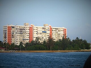
Condos on Isleta Marina, a private island of Fajardo
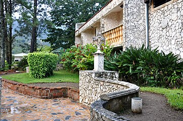
Paved walkway and building in Fajardo

Beach in Fajardo
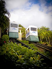
Funicular at El Conquistador Resort in Fajardo
Pier at Cabezas


See also[]
- Bio Bay Night Kayaking Tour
- List of Puerto Ricans
- History of Puerto Rico
- Did you know-Puerto Rico?
- Battle of Fajardo
References[]
- ^ Bureau, US Census. "PUERTO RICO: 2020 Census". The United States Census Bureau. Retrieved 2021-08-25.
- ^ Joseph Prentiss Sanger; Henry Gannett; Walter Francis Willcox (1900). Informe sobre el censo de Puerto Rico, 1899, United States. War Dept. Porto Rico Census Office (in Spanish). Imprenta del gobierno. p. 163. Archived from the original on 2012-11-15. Retrieved 2020-02-29.
- ^ Jump up to: a b "Fajardo Municipality". enciclopediapr.org. Fundación Puertorriqueña de las Humanidades (FPH). Archived from the original on 2020-08-23. Retrieved 2019-03-20.
- ^ "Preliminary Locations of Landslide Impacts from Hurricane Maria, Puerto Rico". USGS Landslide Hazards Program. USGS. Archived from the original on 2019-03-03. Retrieved 2019-03-03.
- ^ "Preliminary Locations of Landslide Impacts from Hurricane Maria, Puerto Rico" (PDF). USGS Landslide Hazards Program. USGS. Archived (PDF) from the original on 2019-03-03. Retrieved 2019-03-03.
- ^ Picó, Rafael; Buitrago de Santiago, Zayda; Berrios, Hector H. Nueva geografía de Puerto Rico: física, económica, y social, por Rafael Picó. Con la colaboración de Zayda Buitrago de Santiago y Héctor H. Berrios. San Juan Editorial Universitaria, Universidad de Puerto Rico,1969. Archived from the original on 2018-12-26. Retrieved 2018-12-30.
- ^ Gwillim Law (20 May 2015). Administrative Subdivisions of Countries: A Comprehensive World Reference, 1900 through 1998. McFarland. p. 300. ISBN 978-1-4766-0447-3. Retrieved 25 December 2018.
- ^ Jump up to: a b Puerto Rico:2010:population and housing unit counts.pdf (PDF). U.S. Dept. of Commerce Economics and Statistics Administration U.S. Census Bureau. 2010. Archived (PDF) from the original on 2017-02-20. Retrieved 2018-12-30.
- ^ "Map of Fajardo at the Wayback Machine" (PDF). Archived from the original (PDF) on 2018-03-24. Retrieved 2018-12-29.
- ^ Jump up to: a b "US Census Barrio-Pueblo definition". factfinder.com. US Census. Archived from the original on 13 May 2017. Retrieved 5 January 2019.
- ^ "P.L. 94-171 VTD/SLD Reference Map 000 (2010 Census): Fajardo Municipio, PR" (PDF). www2.census.gov. U.S. DEPARTMENT OF COMMERCE Economics and Statistics Administration U.S. Census Bureau. Archived (PDF) from the original on 23 August 2020. Retrieved 22 August 2020.
- ^ "P.L. 94-171 VTD/SLD Reference Map 001 (2010 Census): Fajardo Municipio, PR" (PDF). www2.census.gov. U.S. DEPARTMENT OF COMMERCE Economics and Statistics Administration U.S. Census Bureau. Archived (PDF) from the original on 23 August 2020. Retrieved 22 August 2020.
- ^ "P.L. 94-171 VTD/SLD Reference Map 002 (2010 Census): Fajardo Municipio, PR" (PDF). www2.census.gov. U.S. DEPARTMENT OF COMMERCE Economics and Statistics Administration U.S. Census Bureau. Archived (PDF) from the original on 23 August 2020. Retrieved 22 August 2020.
- ^ "Agencia: Oficina del Coordinador General para el Financiamiento Socioeconómico y la Autogestión (Proposed 2016 Budget)". Puerto Rico Budgets (in Spanish). Archived from the original on 28 June 2019. Retrieved 28 June 2019.
- ^ Rivera Quintero, Marcia (2014), El vuelo de la esperanza: Proyecto de las Comunidades Especiales Puerto Rico, 1997-2004 (first ed.), San Juan, Puerto Rico Fundación Sila M. Calderón, ISBN 978-0-9820806-1-0
- ^ "Leyes del 2001". Lex Juris Puerto Rico (in Spanish). Archived from the original on 14 September 2018. Retrieved 24 June 2020.
- ^ Rivera Quintero, Marcia (2014), El vuelo de la esperanza:Proyecto de las Comunidades Especiales Puerto Rico, 1997-2004 (Primera edición ed.), San Juan, Puerto Rico Fundación Sila M. Calderón, p. 273, ISBN 978-0-9820806-1-0
- ^ "Las 1,200 playas de Puerto Rico [The 1200 beaches of Puerto Rico]". Primera Hora (in Spanish). April 14, 2017. Archived from the original on December 12, 2019. Retrieved December 12, 2019.
- ^ Jump up to: a b Soler-López, Luis R. "Laguna Grande Limnology". USGS Caribbean Water Projects. Archived from the original on 23 February 2019. Retrieved 23 February 2019.
- ^ "Trams of the World 2017" (PDF). Blickpunkt Straßenbahn. January 24, 2017. Archived from the original (PDF) on February 16, 2017. Retrieved February 16, 2017.
- ^ "Image of the El Conquistador Resort funicular". Archived from the original on 2017-02-17. Retrieved 2017-11-02.
- ^ http://www.Biobayfajardo.com
- ^ "Puerto Rico Festivales, Eventos y Actividades en Puerto Rico". Puerto Rico Hoteles y Paradores (in Spanish). Archived from the original on 2020-02-26. Retrieved 2020-07-17.
- ^ "Millonaria inversión en Fajardo: Se abre paso el soccer en la Metrópolis del Este | Periódico Presencia". www.presenciapr.com. Archived from the original on 2018-03-15. Retrieved 2018-03-14.
- ^ "U.S. Decennial Census". United States Census Bureau. Archived from the original on April 26, 2015. Retrieved September 21, 2017.
- ^ "Report of the Census of Porto Rico 1899". War Department Office Director Census of Porto Rico. Archived from the original on July 16, 2017. Retrieved September 21, 2017.
- ^ "Table 3-Population of Municipalities: 1930 1920 and 1910" (PDF). United States Census Bureau. Archived (PDF) from the original on August 17, 2017. Retrieved September 21, 2017.
- ^ "Table 4-Area and Population of Municipalities Urban and Rural: 1930 to 1950" (PDF). United States Census Bureau. Archived (PDF) from the original on August 30, 2015. Retrieved September 21, 2014.
- ^ "Table 2 Population and Housing Units: 1960 to 2000" (PDF). United States Census Bureau. Archived (PDF) from the original on July 24, 2017. Retrieved September 21, 2017.
- ^ Bureau, US Census. "PUERTO RICO: 2020 Census". The United States Census Bureau. Retrieved 2021-08-25.
- ^ "Ethnicity 2010 census". Retrieved 2011-11-10.[permanent dead link]
- ^ Elecciones Generales 2012: Escrutinio General Archived February 2, 2013, at the Wayback Machine on CEEPUR
- ^ "Fajardo Bridges". National Bridge Inventory Data. US Dept. of Transportation. Archived from the original on 20 February 2019. Retrieved 19 February 2019.
- ^ "Ley Núm. 70 de 2006 -Ley para disponer la oficialidad de la bandera y el escudo de los setenta y ocho (78) municipios". LexJuris de Puerto Rico (in Spanish). Retrieved 2021-06-15.
- ^ Jump up to: a b "FAJARDO". LexJuris (Leyes y Jurisprudencia) de Puerto Rico (in Spanish). 19 February 2020. Archived from the original on 19 February 2020. Retrieved 17 September 2020.
External links[]
 Media from Wikimedia Commons
 Texts from Wikisource
 Travel guides from Wikivoyage
 Data from Wikidata
- Biobay Fajardo
- Historic Places in Puerto Rico and the Virgin Islands, a National Park Service Discover Our Shared Heritage Travel Itinerary
| show Places adjacent to Fajardo, Puerto Rico |
|---|
| show Authority control |
|---|
- Fajardo, Puerto Rico
- Municipalities of Puerto Rico
- Fajardo metropolitan area
- Populated places established in 1772