Guatemala, San Sebastián, Puerto Rico
Guatemala | |
|---|---|
Barrio | |
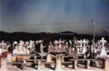
  Clockwise from top: Panorama of Guatemala, Trees at Veredas Sports Complex | |
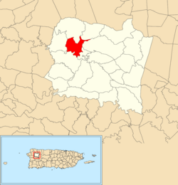 Location of Guatemala within the municipality of San Sebastián shown in red | |
 Guatemala Location of Puerto Rico | |
| Coordinates: 18°21′10″N 67°00′24″W / 18.352668°N 67.006689°WCoordinates: 18°21′10″N 67°00′24″W / 18.352668°N 67.006689°W[1] | |
| Commonwealth | |
| Municipality | |
| Area | |
| • Total | 2.16 sq mi (5.6 km2) |
| • Land | 2.16 sq mi (5.6 km2) |
| • Water | 0 sq mi (0 km2) |
| Elevation | 223 ft (68 m) |
| Population (2010) | |
| • Total | 2,512 |
| • Density | 1,163/sq mi (449/km2) |
| Source: 2010 Census | |
| Time zone | UTC−4 (AST) |

Guatemala is a barrio in the municipality of San Sebastián, Puerto Rico. Its population in 2010 was 2,512.[3][4][5]
The Guatemala River is located in Guatemala barrio.
History[]
Puerto Rico was ceded by Spain in the aftermath of the Spanish–American War under the terms of the Treaty of Paris of 1898 and became an unincorporated territory of the United States. In 1899, the United States Department of War conducted a census of Puerto Rico finding that the population of Guatemala barrio and Bahomamey barrio was 1,126.[6]
| Historical population | |||
|---|---|---|---|
| Census | Pop. | %± | |
| 1980 | 2,544 | — | |
| 1990 | 3,030 | 19.1% | |
| 2000 | 2,919 | −3.7% | |
| 2010 | 2,512 | −13.9% | |
| U.S. Decennial Census[7] 1899 (shown as 1900)[8] 1910-1930[9] 1930-1950[10] 1980-2000[11] 2010[12] | |||
Sectors[]
Barrios (which are roughly comparable to minor civil divisions)[13] in turn are further subdivided into smaller local populated place areas/units called sectores (sectors in English). The types of sectores may vary, from normally sector to urbanización to reparto to barriada to residencial, among others.[14][15][16]
The following sectors are in Guatemala barrio:[17]
Avenida Emérito Estrada Rivera, Carretera 111, Carretera 125, Carretera 445, Carretera 446, Sector Barandillo, Sector Bejuco, Sector Central Plata, Sector Colón, Sector Goyin Rámirez, Sector Javilla, Sector Laberinto, Sector La Vega, Sector Marcelo Pérez, Sector Méndez, Sector Peña, Sector Rincón (Gozalandia), Sector Salsipuedes, Sector Torres, Urbanización Extensión Villa Rita, Urbanización Jardines de Guatemala, Urbanización Mansiones de Loma Linda, Urbanización San Antonio de La Plata, Urbanización San Carmelo de la Plata, and Urbanización Villa Rita.
Features[]
The Guatemala River passes through Guatemala in San Sebastián. There is a sports complex featuring a museum of an hacienda. San Sebastián Memorial is located in Guatemala.
Veredas Sports Complex[]
Established in 2016 in Guatemala is the Veredas Sports Complex. The complex which consists of a modern skate park, a sand volleyball court, a zipline with four stations, a climbing and rappelling wall, an outdoor gym, a rope bridge, basketball and tennis courts, and walking paths, is set within an urban forest of about six thousand trees. Hacienda La Fe, an agriculture museum is located at the complex.[18]
Gallery[]
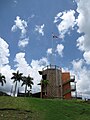
Rock climbing wall at Veredas Sports Complex in Guatemala
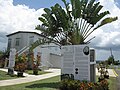
Hacienda la Fe museum at Veredas Sports Complex in Guatemala
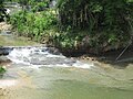
Guatemala River in Guatemala

Guatemala River in Guatemala barrio
San Sebastián Memorial


See also[]
References[]
- ^ a b "US Gazetteer 2019". US Census. US Government.
- ^ U.S. Geological Survey Geographic Names Information System: Guatemala barrio
- ^ Picó, Rafael; Buitrago de Santiago, Zayda; Berrios, Hector H. Nueva geografía de Puerto Rico: física, económica, y social, por Rafael Picó. Con la colaboración de Zayda Buitrago de Santiago y Héctor H. Berrios. San Juan Editorial Universitaria, Universidad de Puerto Rico,1969.
- ^ Gwillim Law (20 May 2015). Administrative Subdivisions of Countries: A Comprehensive World Reference, 1900 through 1998. McFarland. p. 300. ISBN 978-1-4766-0447-3. Retrieved 25 December 2018.
- ^ Puerto Rico:2010:population and housing unit counts.pdf (PDF). U.S. Dept. of Commerce, Economics and Statistics Administration, U.S. Census Bureau. 2010.
- ^ Joseph Prentiss Sanger; Henry Gannett; Walter Francis Willcox (1900). Informe sobre el censo de Puerto Rico, 1899, United States. War Dept. Porto Rico Census Office (in Spanish). Imprenta del gobierno. p. 160.
- ^ "U.S. Decennial Census". United States Census Bureau. Archived from the original on February 13, 2020. Retrieved September 21, 2017.
- ^ "Report of the Census of Porto Rico 1899". War Department Office Director Census of Porto Rico. Archived from the original on July 16, 2017. Retrieved September 21, 2017.
- ^ "Table 3-Population of Municipalities: 1930 1920 and 1910" (PDF). United States Census Bureau. Archived (PDF) from the original on August 17, 2017. Retrieved September 21, 2017.
- ^ "Table 4-Area and Population of Municipalities Urban and Rural: 1930 to 1950" (PDF). United States Census Bureau. Archived (PDF) from the original on August 30, 2015. Retrieved September 21, 2014.
- ^ "Table 2 Population and Housing Units: 1960 to 2000" (PDF). United States Census Bureau. Archived (PDF) from the original on July 24, 2017. Retrieved September 21, 2017.
- ^ Puerto Rico:2010:population and housing unit counts.pdf (PDF). U.S. Dept. of Commerce Economics and Statistics Administration U.S. Census Bureau. 2010. Archived (PDF) from the original on 2017-02-20. Retrieved 2019-08-02.
- ^ "US Census Barrio-Pueblo definition". factfinder.com. US Census. Archived from the original on 13 May 2017. Retrieved 5 January 2019.
- ^ "Agencia: Oficina del Coordinador General para el Financiamiento Socioeconómico y la Autogestión (Proposed 2016 Budget)". Puerto Rico Budgets (in Spanish). Retrieved 28 June 2019.
- ^ Rivera Quintero, Marcia (2014), El vuelo de la esperanza: Proyecto de las Comunidades Especiales Puerto Rico, 1997-2004 (first ed.), San Juan, Puerto Rico Fundación Sila M. Calderón, ISBN 978-0-9820806-1-0
- ^ "Leyes del 2001". Lex Juris Puerto Rico (in Spanish). Retrieved 24 June 2020.
- ^ "PRECINTO ELECTORAL SAN SEBASTIÁN 033" (PDF). Comisión Estatal de Elecciones (in Spanish). PR Government. 19 October 2018. Retrieved 19 June 2019.
- ^ "¡Qué muchas atracciones en San Sebastián del Pepino!". Primera Hora (in Spanish). 11 June 2013.
This San Sebastián, Puerto Rico location article is a stub. You can help Wikipedia by . |
- Barrios of San Sebastián, Puerto Rico
- Puerto Rico Senatorial district IV geography stubs