Emajagua
Emajagua | |
|---|---|
Barrio | |
 Villa Pesquera in Emajagua from the nearby fishing pier | |
 Location of Emajagua within the municipality of Maunabo shown in red | |
 Emajagua Location of Puerto Rico | |
| Coordinates: 18°00′18″N 65°52′37″W / 18.005136°N 65.876821°WCoordinates: 18°00′18″N 65°52′37″W / 18.005136°N 65.876821°W[1] | |
| Commonwealth | |
| Municipality | |
| Area | |
| • Total | 5.76 sq mi (14.9 km2) |
| • Land | 4.14 sq mi (10.7 km2) |
| • Water | 1.62 sq mi (4.2 km2) |
| Elevation | 59 ft (18 m) |
| Population (2010) | |
| • Total | 4,538 |
| • Density | 1,096.1/sq mi (423.2/km2) |
| Source: 2010 Census | |
| Time zone | UTC−4 (AST) |

Emajagua is a barrio in the municipality of Maunabo, Puerto Rico with a population of 4,538 in 2010.[3]
Features[]

Túnel Vicente Morales Lebrón in Emajagua
The Vicente Morales Lebrón Tunnel is in Emajagua.
History[]
Puerto Rico was ceded by Spain in the aftermath of the Spanish–American War under the terms of the Treaty of Paris of 1898 and became an unincorporated territory of the United States. In 1899, the United States Department of War conducted a census of Puerto Rico finding that the population of Emajagua barrio was 828.[4]
| Historical population | |||
|---|---|---|---|
| Census | Pop. | %± | |
| 1900 | 828 | — | |
| 1980 | 3,140 | — | |
| 1990 | 3,719 | 18.4% | |
| 2000 | 4,515 | 21.4% | |
| 2010 | 4,538 | 0.5% | |
| U.S. Decennial Census[5] 1899 (shown as 1900)[6] 1910-1930[7] 1930-1950[8] 1980-2000[9] 2010[10] | |||
Gallery[]
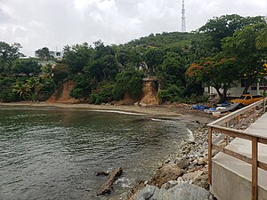
Villa Pesquera in Emajagua is a place with a fishing pier.

The Villa Pesquera parking area


See also[]
References[]
- ^ a b "US Gazetteer 2019". US Census. US Government.
- ^ U.S. Geological Survey Geographic Names Information System: Emajagua barrio
- ^ Puerto Rico:2010:population and housing unit counts.pdf (PDF). U.S. Dept. of Commerce, Economics and Statistics Administration, U.S. Census Bureau. 2010.
- ^ Joseph Prentiss Sanger; Henry Gannett; Walter Francis Willcox (1900). Informe sobre el censo de Puerto Rico, 1899, United States. War Dept. Porto Rico Census Office (in Spanish). Imprenta del gobierno. p. 163.
- ^ "U.S. Decennial Census". United States Census Bureau. Archived from the original on 13 February 2020. Retrieved 21 September 2017.
- ^ "Report of the Census of Porto Rico 1899". War Department Office Director Census of Porto Rico. Archived from the original on 16 July 2017. Retrieved 21 September 2017.
- ^ "Table 3-Population of Municipalities: 1930 1920 and 1910" (PDF). United States Census Bureau. Archived (PDF) from the original on 17 August 2017. Retrieved 21 September 2017.
- ^ "Table 4-Area and Population of Municipalities Urban and Rural: 1930 to 1950" (PDF). United States Census Bureau. Archived (PDF) from the original on 30 August 2015. Retrieved 21 September 2014.
- ^ "Table 2 Population and Housing Units: 1960 to 2000" (PDF). United States Census Bureau. Archived (PDF) from the original on 24 July 2017. Retrieved 21 September 2017.
- ^ Puerto Rico:2010:population and housing unit counts.pdf (PDF). U.S. Dept. of Commerce Economics and Statistics Administration U.S. Census Bureau. 2010. Archived (PDF) from the original on 20 February 2017. Retrieved 2 August 2019.
This Maunabo, Puerto Rico location article is a stub. You can help Wikipedia by . |
Categories:
- Barrios of Maunabo, Puerto Rico
- Puerto Rico Senatorial district VII geography stubs