Andersonville, Indiana
Andersonville, Indiana | |
|---|---|
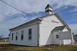 Andersonville Christian Church | |
 Andersonville | |
| Coordinates: 39°29′51″N 85°17′20″W / 39.49750°N 85.28889°WCoordinates: 39°29′51″N 85°17′20″W / 39.49750°N 85.28889°W | |
| Country | |
| State | |
| County | Franklin County |
| Township | Posey Township |
| Elevation | 320 m (1,050 ft) |
| ZIP code | 47024 |
| GNIS feature ID | 0430167 |

Andersonville is an unincorporated community in Posey Township in the northwest corner of Franklin County, Indiana, United States.
History[]
In 1820 on the 17th of October the government granted 160 acers to John & Simeon Barber/Barbour. Andersonville, the original town known as Ceylon, was laid out in Oct.1831 by Simeon Barber in 1831 it was 78 lots.The original streets (in use today) was laid out 66 feet wide & alleys were 16 1/2 feet wide. The Anderson Addition was laid out by Joel(Joseph) Anderson & Fletcher Tevis in 1837 with additionallots & streets. Anderson P.O.was established. The 2 additions merged and It was renamed in 1849 after Thomas Anderson, a tavern owner. In 1915, Andersonville had about 350 inhabitants.[1]
Geography[]
Andersonville is located at 39°29′51″N 85°17′20″W / 39.49750°N 85.28889°W at an elevation of 1050 feet. It lies at the intersection of U.S. Route 52 and the east end of Indiana State Road 244; this forms an acute angle, and the named streets run north and south in the triangle thus formed.
Notes[]
- ^ Reifel, August Jacob (1915). History of Franklin County, Indiana. Windmill Publications. pp. 126.
References[]
Municipalities and communities of Franklin County, Indiana, United States | ||
|---|---|---|
| City | ||
| Towns | ||
| Townships | ||
| CDPs | ||
| Other unincorporated communities |
| |
| Footnotes | ‡This populated place also has portions in an adjacent county or counties | |
| ||
This Franklin County, Indiana location article is a stub. You can help Wikipedia by . |
- Unincorporated communities in Franklin County, Indiana
- Unincorporated communities in Indiana
- Southern Indiana geography stubs