Unincorporated area

An unincorporated area is a region not governed by a local municipal corporation. Similarly, an unincorporated community is a settlement not governed by its own local municipal corporation, but is administered as part of larger administrative divisions, such as a township, parish, borough, county, city, canton, state, province, or country. Occasionally, municipalities dissolve or disincorporate, which may happen if they become fiscally insolvent, and services become the responsibility of a higher administration. Widespread unincorporated communities and areas are a distinguishing feature of the United States and Canada. Most other countries of the world have either no unincorporated areas at all, or these are very rare; typically remote, outlying, sparsely populated, or uninhabited areas.
By country[]
Argentina[]
In Argentina, the provinces of Chubut, Córdoba, Entre Ríos, Formosa, Neuquén, Río Negro, San Luis, Santa Cruz, Santiago del Estero, Tierra del Fuego, and Tucumán have areas that are outside any municipality or commune.
Australia[]
Unlike many other countries, Australia has only one level of local government immediately beneath state and territorial governments. A local government area (LGA) often contains several towns and even entire cities. Thus, aside from very sparsely populated areas and a few other special cases, almost all of Australia is part of an LGA. Unincorporated areas are often in remote locations, cover vast areas, or have very small populations.
Postal addresses in unincorporated areas, as in other parts of Australia, normally use the suburb or locality names gazetted by the relevant state or territorial government. Thus, any ambiguity regarding addresses rarely exists in unincorporated areas.
Queensland, Tasmania, and Western Australia are entirely partitioned into LGAs and have no unincorporated areas.
Australian Capital Territory[]
The Australian Capital Territory (ACT) has no municipalities. The territorial government is directly responsible for matters normally carried out by a local government. In some countries, this arrangement would be referred to as a unitary authority, but the Australian Bureau of Statistics refers to the whole of the ACT as an unincorporated area.[1]
New South Wales[]
The far west and north of New South Wales constitutes the Unincorporated Far West Region, which is sparsely populated and barely warrants an elected council. A civil servant in the state capital manages such matters as are necessary. The second unincorporated area of this state is Lord Howe Island.
Northern Territory[]
In the Northern Territory, 1.45% of the total area and 4.0% of the population are in unincorporated areas, including the Unincorporated Top End Region (the largest), areas covered by the Northern Territory Rates Act, Nhulunbuy, the community of Alyangula on Groote Eylandt in the northern region, and Yulara in the southern region.[2]
South Australia[]
In South Australia, 60% of the area is unincorporated and communities located within can receive municipal services provided by a state agency, the Outback Communities Authority.[3]
Victoria[]
Victoria has 10 small unincorporated areas, which are either small islands directly administered by the state or ski resorts administered by state-appointed management boards.[2]
Canada[]
In Canada, depending on the province, an unincorporated settlement is one that does not have a municipal council that governs solely over the settlement. It is usually, but not always, part of a larger municipal government. This can range from being a small hamlet to being a large urbanized area that is similar in size to a town or city.
For example, were they incorporated, the urban service areas of Fort McMurray in the Regional Municipality of Wood Buffalo and Sherwood Park in Strathcona County would be the fifth- and sixth-largest cities in Alberta.
In British Columbia, unincorporated settlements lie outside municipal boundaries entirely, and are administered directly by regional/county-level governments similar to the American system.
Unincorporated settlements with a population between 100 and 1,000 residents may have the status of designated place in Canadian census data.[4]
In some provinces, large tracts of undeveloped wilderness or rural country are unorganized areas that fall directly under the provincial jurisdiction. Some unincorporated settlements in such unorganized areas may have some types of municipal services provided to them by a quasigovernmental agency such as a local services board in Ontario. In New Brunswick, where a significant population lives in a local service district, taxation and services may come directly from the province.
Czech Republic[]

The entire area of the Czech Republic is divided into municipalities (obce, sg. obec), with the only exception being four military areas. These are parts of the regions and do not form self-governing municipalities, but are rather governed by military offices (újezdní úřad), which are subordinate to the Ministry of Defence.
| Military area | Region | Civilian population (2016) |
Administrative centre | No. of settlements with over 20 inhabitants |
Area (km2, 2016) |
|---|---|---|---|---|---|
| Libavá | Olomouc | 0 | Město Libavá (outside the military area) |
0 | 327 |
| Hradiště | Karlovy Vary | 0 | Karlovy Vary (outside the military area) |
0 | 332 |
| Boletice | South Bohemian | 0 | Kájov (outside the military area) |
0 | 219 |
| Brdy † | Central Bohemian | 0 | Jince (outside the military area) |
0 | 260 |
| Březina | South Moravian | 0 | Vyškov (outside the military area) |
0 | 158 |
- † Brdy Military Area was abandoned by the army in 2015 and converted into Landscape park, with its area being incorporated either into existing municipalities or municipalities newly established from the existing settlements. The other four Military Areas were reduced in size in 2015 too. The decisions on whether the settlements join existing municipalities or form new ones are decided in plebiscites.[5]
Germany[]
Since Germany has no administrative level comparable to the townships of other countries, the vast majority of the country, close to 99%, is organized in municipalities (German: Gemeinde, plural Gemeinden), often consisting of multiple settlements that are not considered to be unincorporated. Because these settlements lack a council of their own, usually an Ortsvorsteher or Ortsvorsteherin (village chairman / chairwoman) is appointed by the municipal council, except in the very smallest villages.
In 2000, the number of unincorporated areas in Germany, called gemeindefreie Gebiete (municipality-free areas) or singular gemeindefreies Gebiet, was 295 with a total area of 4,890.33 km2 and around 1.4% of its territory. However, these are mostly unpopulated areas such as forests, lakes and their surroundings, military training areas, and the like.
As of 31 December 2007, Germany had 248 uninhabited unincorporated areas (of which 214 are located in Bavaria), not belonging to any municipality, consisting mostly of forested areas, lakes, and larger rivers. Also, three inhabited unincorporated areas existed, all of which served as military training areas: Osterheide and Lohheide in Lower Saxony, and Gutsbezirk Münsingen in Baden-Württemberg. They had fewer than 2,000 inhabitants in total. After losing its inhabited parts to adjacent municipalities on 1 January 2011, Gutsbezirk Münsingen is now uninhabited.[6]
Largest []
The following shows the largest unincorporated areas in Germany (including all inhabited areas, but excluding lakes) with an area of more than 50 km2:
| Regional number |
Unincorporated area | County | State | Area in km2 | Population on 31 December 2010 |
|---|---|---|---|---|---|
| 031530000504 | Harz (Landkreis Goslar) | Goslar | Lower Saxony | 371.76 | – |
| 031560000501 | Harz (Landkreis Osterode) | Osterode am Harz | Lower Saxony | 267.35 | – |
| 066330000200 | Gutsbezirk Reinhardswald | Kassel | Hesse | 182.58 | – |
| 033580000501 | Osterheide | Heidekreis | Lower Saxony | 177.99 | 762 |
| 031550000501 | Northeim | Lower Saxony | 177.49 | – | |
| 033510000501 | Lohheide | Celle | Lower Saxony | 91.32 | 716 |
| 064350000200 | Gutsbezirk Spessart | Main-Kinzig-Kreis | Hesse | 89.30 | – |
| 091800000451 | Garmisch-Partenkirchen | Bavaria | 83.46 | – | |
| 084150000971 | Gutsbezirk Münsingen | Reutlingen | Baden-Württemberg | 64.68 | 160 |
| 010535303105 | Sachsenwald | Herzogtum Lauenburg | Schleswig-Holstein | 58.49 | – |
| 094720000468 | Bayreuth | Bavaria | 55.60 | – | |
| 033540000502 | Göhrde | Lüchow-Dannenberg | Lower Saxony | 51.81 | – |
| 033540000501 | Lüchow-Dannenberg | Lower Saxony | 50.92 | – | |
| 066360000200 | Werra-Meißner-Kreis | Hesse | 50.32 | – |
† No inhabitants since 1 January 2011 as a result of reduction in area.
In Bavaria, there are other contiguous unincorporated areas covering more than 50 km2; these are however composed of several adjacent unincorporated areas combined, each of which is however under 50 km2 in area.
Netherlands[]
The Netherlands has had regular periods with unincorporated land when newly reclaimed land polders fall dry. Unincorporated land is since medieval times administered by an appointed officer with the name Landdrost or Drossaart. Also, Elten and Tudderen, both annexed from Germany after World War II, were governed by a Landdrost until they were ceded to Germany in 1963.
The most recent period with unincorporated land started in 1967, when the dyke around Southern Flevoland was closed, but several years are required before the polder is genuinely accessible for cultivation, and construction of roads and homes can start, as in the first years, the soil is equivalent to quicksand. During the initial period of inhabitation, a special, government-appointed officer was installed, the Landdrost. During the administrative office of a Landdrost, no municipal council forms.
In 1975, the first homes in what is now the city of Almere were built, and from 1976 to 1984, the area was governed by the Landdrost as the executive of the Openbaar Lichaam Zuidelijke IJsselmeerpolders (Southern IJsselmeerpolders Public Body). In 1984, the Landdrost became the first mayor of the new city Almere. Since that date, the Netherlands does not have any unincorporated land areas.
The Openbaar Lichaam remained, however, only governing the water body of the Markermeer. After the municipal division of the Wadden Sea (1985), the territorial waters in the North Sea (1991) and the IJsselmeer (1994), all water bodies are now also part of a municipality[7] and no unincorporated areas exist in the Netherlands anymore. The Openbaar Lichaam Zuidelijke IJsselmeerpolders was dissolved in 1996.
Norway[]
In Norway, Bouvet Island, Jan Mayen, and Svalbard are outside of any of the country's counties and municipalities. They are ruled directly by national authorities without any local democracy. An exception is the Longyearbyen Community Council, which since 2004 in reality acts partly like a Norwegian municipality. Svalbard has a governor appointed by the government of Norway, ruling the area. Jan Mayen has no population, only radio and weather stations with staff, whose manager has the responsibility for the activities. Bouvet Island has only occasional visitors.
United States[]
In local government in the United States, an unincorporated area generally refers to the part of a county that is outside any municipality.
An unincorporated community is one general term for a geographic area having a common social identity without municipal organization or official political designation (i.e., incorporation as a city or town). The two main types of unincorporated communities are:
- a neighborhood or other community existing within one or across multiple existing incorporated areas (i.e., cities or towns). In this sense, a community is part of a municipal government, but not separately incorporated from it. For example, Hyannis, Massachusetts, is an unincorporated village within the town of Barnstable, and Intervale, New Hampshire, is an unincorporated community on the border of the towns of Bartlett and Conway.
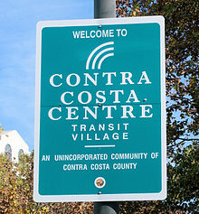
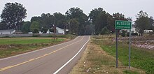
- a neighborhood or other community existing outside an incorporated municipal government. In this sense, the community is outside any municipal government, and entirely unincorporated. Examples include Hovland, Minnesota; Nutbush, Tennessee; and Yucca, Arizona; all are small rural settlements of low population.
Most states have granted some form of home rule, so that county commissions (or boards or councils) have the same powers in these areas as city councils or town councils have in their respective incorporated areas.[8] Some states, instead, put these powers in the hands of townships, which are minor civil divisions of each county, and are called "towns" in some states.
Due to differences in state laws regarding the incorporation of communities, a great variation exists in the distribution and nature of unincorporated areas. Unincorporated regions are essentially nonexistent in eight of the northeastern states. All of the land in New Jersey, Connecticut, Massachusetts, New York, and Rhode Island, and nearly all of the land in New Hampshire, Pennsylvania, and Vermont, is part of an incorporated area of some type. In these areas, types (and official names) of local government entities can vary. In New England (which includes five of those eight states, plus the less fully incorporated state of Maine), local municipalities are known as towns or cities, and most towns are administered by a form of direct democracy, such as the open town meeting or representative town meeting. Larger towns in New England may be incorporated as cities, with some form of mayor-council government. In New Jersey, multiple types exist, as well, such as city, township, town, borough, or village, but these differences are in the structure of the legislative branches, not in the powers or functions of the entities themselves.

On the opposite end of the spectrum is the Virginia "strong county" model.[9] Virginia and other states with this model, such as Alabama, Maryland, and Tennessee, set strict requirements on incorporation or grant counties broad powers that in other states are carried out by cities, creating a disincentive to incorporate, and thus have large, urbanized areas which have no municipal government below the county level.
Meanwhile, in other mid-Atlantic states, such as New York and Pennsylvania, a hybrid model[9] that tries to balance the two approaches is prevalent,[10] with differing allocations of power between municipalities and counties existing.
Throughout the U.S., some large cities have annexed all surrounding unincorporated areas within their counties, creating what are known as consolidated city–county forms of government (e.g., Jacksonville, Florida and Nashville, Tennessee). In these cases, unincorporated areas continue to exist in other counties of their respective metropolitan areas. Conversely, there are a number of "county islands" that exist, where an unincorporated area is surrounded on most or all sides by municipalities. In areas of sparse population the majority of the land in any given state may be unincorporated.
Some states, including North Carolina, grant extraterritorial jurisdiction to cities and towns (but rarely villages), so that they may control zoning for a limited distance into adjacent unincorporated areas, often as a precursor (and sometimes as a legal requirement) to later annexation of those areas. This is especially useful in rural counties that have no zoning at all, or only spot zoning for unincorporated communities.
In California, all counties except the City and County of San Francisco have unincorporated areas. Even in highly populated counties, the unincorporated portions may contain a large number of inhabitants. In Los Angeles County, the county government estimates the population of its unincorporated areas to exceed one million people.[11] Despite having 88 incorporated cities and towns, including the state's most populous, 65% of the land in Los Angeles County is unincorporated, this mostly consisting of Angeles National Forest and sparsely populated regions to its north.[12] California law makes no distinction between "city" and "town", and municipalities may use either term in their official names.[13]
Insular areas[]
In the context of the insular areas of the United States, the word "unincorporated" refers to territories in which the United States Congress has determined that only selected parts of the United States Constitution apply, and which have not been formally incorporated into the United States by Congress. Currently, the five major unincorporated U.S. insular areas are American Samoa, Puerto Rico, Guam, the U.S. Virgin Islands, and the Northern Mariana Islands.[14] Unincorporated insular areas can be ceded to another nation or be granted independence.[15] The U.S. has one incorporated insular area, Palmyra Atoll. Incorporation is regarded as perpetual by the U.S. federal government; once incorporated, the Territory cannot be disincorporated.[14] (See: United States territory.) The [[[U.S. Minor Outlying Islands]] without a permanent civilian population are "unorganized" in the sense that they do not have a local government and they are administered by the Office of Insular Affairs directly. The populated American Samoa is also "unorganized" in the sense that Congress has not passed an organic act but it does have a constitution and locally elected territorial legislature and executive.
U.S. Census Bureau[]
An unincorporated community may be part of a census-designated place (CDP). A CDP is an area defined by the United States Census Bureau for statistical purposes only. It is a populated area that generally includes one officially designated, but currently unincorporated community, for which the CDP is named, plus surrounding inhabited countryside of varying dimensions, and occasionally, other, smaller unincorporated communities, as well. Otherwise, it has no legal status.[16]
The Census Bureau designates some unincorporated areas as "unorganized territories", as defined by the U.S. Census Bureau where portions of counties are not included in any legally established minor civil division (MCD) or independent incorporated place. These occur in 10 MCD states: Arkansas, Indiana, Iowa, Louisiana, Maine, Minnesota, North Carolina, North Dakota, Ohio, and South Dakota. The Census recognizes such separate pieces of territory as one or more separate county subdivisions for statistical purposes. It assigns each unorganized territory a descriptive name, followed by the designation "unorganized territory". Unorganized territories were first used for statistical purposes in conjunction with the 1960 census.[17]
At the 2000 census there were 305 of these territories within the United States. Their total land area was 85,392 square miles (221,165 km2) and they had a total population of 247,331. South Dakota had the most unorganized territories, 102, as well as the largest amount of land under that status: 39,785 square miles (103,042 km2), or 52.4% of the state's land area. North Dakota followed with 86 territories, 20,358 square miles (52,728 km2), or 29.5% of its land area. Maine was next with 36 territories, 14,052 square miles (36,396 km2), or 45.5% of its land area. Minnesota had 71 territories, 10,552 square miles (27,330 km2), or 13% of its land area. Several other states had small amounts of unorganized territory. The unorganized territory with the largest population was Camp Lejeune, North Carolina, a United States Marine Corps base with a census population of 34,452 inhabitants.
In the 2010 census, unorganized territory areas were identified in nine U.S. states: Arkansas, Indiana, Iowa, Maine, Minnesota, New York, North Carolina, North Dakota, and South Dakota.[18]
USGS definition of "populated place"[]
Unincorporated areas with permanent populations in the United States are defined by the US government scientific agency United States Geological Survey (USGS) as "populated places", a "place or area with clustered or scattered buildings, and a permanent human population (city, settlement, town, village)." No legal boundaries exist, although a corresponding "civil" record may occur, the boundaries of which may or may not match the perceived populated place.[19]
U.S. mail delivery[]
Many unincorporated communities are also recognized as acceptable place names for use in mailing addresses by the United States Postal Service (USPS) (indeed, some have their own post offices), and the United States Census Bureau uses the names of some widely recognized unincorporated communities for its CDPs for which it tabulates census data.
In some instances, unincorporated areas have a mailing address indicating the name of an incorporated city,[citation needed] as well as those where residents of one incorporated city have mailing addresses indicating another incorporated city. Mailing addresses do not necessarily change whether an area becomes a part of an incorporated place, changes to another incorporated place, or disincorporates. For example, places in Kingwood, Texas, previously unincorporated, retained "Kingwood, TX" mailing addresses after the 1996 annexation of Kingwood into the City of Houston. The Houston city government stated on its website, "The U.S. Postal Service establishes ZIP codes and mailing addresses to maximize the efficiency of their system, not to recognize jurisdictional boundaries."[20]
The USPS is very conservative about recognizing new place names for use in mailing addresses and typically only does so when a place incorporates.[citation needed] The original place name associated with a ZIP Code is still maintained as the default place name, even though the name of the newly incorporated place is more accurate. As an example, Sandy Springs is one of the most populated places in Georgia, but is served by a branch of the Atlanta post office. Only after the city was incorporated in 2005 has "Sandy Springs" been approved by the USPS for use in mailing addresses, though "Atlanta" remains the default name. Accordingly, "Atlanta" is the only accepted place name for mailing addresses in the nearby unincorporated town of Vinings, also served by a branch of the Atlanta post office, even though Vinings is in Cobb County and Atlanta is in Fulton and DeKalb counties. In contrast, neighboring Mableton has not been incorporated in nearly a century, but has its own post office and thus "Mableton" is the only acceptable place name for mailing addresses in the town. The areas of Dulah and Faria, California, which are unincorporated areas in Ventura County between Ventura and Carpinteria, have the ZIP Code of 93001, which is assigned to the post office at 675 E. Santa Clara St. in Ventura;[21] thus, all mail to those two areas is addressed to Ventura.
If an unincorporated area becomes incorporated, it may be split among ZIP codes, and its new name may be recognized as acceptable for use with some or all of them in mailing addresses, as has been the case in Johns Creek and Milton, Georgia. If an incorporated area disincorporates, though, this has no effect on whether a place name is "acceptable" in a mailing address or not, as is the case with Lithia Springs, Georgia. ZIP code boundaries often ignore political boundaries, so the appearance of a place name in a mailing address alone does not indicate whether the place is incorporated or unincorporated.
Other nations[]
Some nations have some exceptional unincorporated areas:
- The Kingdom of Denmark has three unincorporated areas:
- In Denmark proper, the former naval fortress Ertholmene east of Bornholm with less than 100 inhabitants is still governed directly by the Ministry of Defence.
- In Greenland, all land is incorporated except for the Northeast Greenland National Park and the Thule Air Base.
- France (exceptions are some small overseas possessions)
- Hong Kong (except for the Lok Ma Chau Loop) is divided into districts.[22]
- Azad Kashmir has no official status in Pakistani law, but is nonetheless de facto governed by Pakistan.[23]
- In Israel, all land, except military areas, is subdivided into 393 municipalities which are further classified, normally by population, as City, Local Council, or Regional Council. All three types of municipality provide services including zoning and planning.
- In India, there are several Union Territories ('centrally administered province'). Unlike the States of India, which have their own governments, union territories are federal territories governed, in part or in whole, by the Central Government of India. Many of these were created at the time of India's independence or after being acquired from non-British colonial powers or princely states.
- Slovakia is divided into municipalities. There are two types of municipalities: towns (mesto, pl. mestá) and villages (obec, pl. obce), with minor differences between them. Additionally, there are several military areas which are not part of any municipality. Each military area is a municipality of its own right. However, the military areas hold no elections and have no mayors or other elected representatives. Instead, they are administered directly by the Slovak Ministry of Defence.
- Switzerland also has a few exceptions: 22 lakes and a forest, as described by the Swiss federal statistical office (See: Gemeindefreie Gebiete (in German)).
- In Ukraine, all land is divided into hromadas except for the Chernobyl Exclusion Zone. The latter contains parts of Kyiv Oblast and Zhytomyr Oblast and is directly administered by a designated government agency.
Countries without unincorporated areas[]
Many countries, especially those with many centuries of history using multiple tiers of local government, do not use the concept of an unincorporated area.
- The whole of the territories of Austria, Belgium, Bosnia and Herzegovina, Croatia, Finland, France, Greece, Italy, Japan, Lithuania, Montenegro, the Netherlands, the Philippines, Poland, Portugal, Serbia, Slovenia, Sweden and Turkey are divided into municipalities.
- In Brazil, Chile, Colombia, and Mexico, all land must belong to a municipality. Even large uninhabited areas, such as forests or grasslands, are, by law, part of the nearest "city". This is because in Latin America, a "municipality" is the equivalent of what in the United States and Canada is called a "county".
- In Mainland China, every piece of land belongs to a county-level (third level) administrative division (equivalent to a municipality), either a district (区 qū) in an urban area, or a county-level city (县级市 xiànjíshì), county (县 xiàn) or banner (旗 qí). There is also a township-level (fourth level) administrative division, which may be a subdistrict (街道 jiēdào), town (镇 zhèn), township (乡 xiāng), or sumu (苏木 sūmù).[24]
- In Croatia, every piece of land belongs either to a city (grad) or to a municipality (općina).
- In Estonia, the entire territory is divided into 79 municipalities, of which 14 are municipal towns and 65 are parishes. The entire territory of the country is divided into settlements of four types: towns, boroughs, small boroughs and villages.
- In France, the territory is subdivided into 36,685 communes (municipalities).[25] An elected council and a mayor form the governing body of a municipality.
- In Indonesia, every piece of land belongs to a municipality (kotamadya) or a regency (kabupaten).
- In Japan, every piece of land belongs to a municipality, of which there are four types: cities (市 shi); the special wards (特別区 tokubetsu-ku) of Tokyo; towns (町 chō or machi); villages (村 mura or son).
- In Peru, the whole territory is divided into districts ("distritos"), which form provinces ("provincias"), which form regions ("regiones"). Some districts, especially in the Amazon, are vast portions of territory, but they're governed from a district capital (which can be anywhere from a city to a small village).
- In the Philippines, all land belongs to either a city or a municipality, which are further subdivided into barangays.
- In Portugal, the constitution defines territorial divisions as parishes, municipalities, and administrative regions.[26] It has no official definition of city limits, so a city may include several parishes, or a parish may cover several villages or townships, but a municipality is usually administered from the city or town that bears its name.
- In South Africa, the constitution gives every place in the country democratically elected third-tier government.
- In South Korea, every piece of land belongs to a municipality, either a district (구/區 gu) in a city (시/市 shi) or a town (읍/邑 eub) or township (면/面 myeon) in a county (군/郡 gun).
- In Spain, the Spanish Constitution of 1978 says that the land is divided into Autonomous Communities, provinces and municipalities. Each of these have certain powers determined by law. Autonomous Communities and municipalities are enabled to appeal to the Constitutional Court any public decision that violates their autonomy by other entities (State or Autonomous Community power). Nevertheless, some regions, like Navarre, have some unincorporated areas. The largest of these, the Bardenas Reales has a surface of 418 km2 and is governed by a board of representatives of 20 bordering municipalities, a valley in the Pyrenees, and a monastery, all of which have rights to use the area. The plazas de soberanía also functions as a de facto unincorporated area[27] under the administration of the Spanish Ministry of Defence.[28]
- In Sweden, all territory is divided into municipalities. Sweden has post-glacial rebound, meaning the land is rising by up to a meter (3 ft) per century compared to sea level. But municipal borders extend into sea, giving such new areas a defined municipal belonging.
- In the free area of the Republic of China (Taiwan Island, Penghu, Kinmen, Matsu and some minor islands), every piece of land belongs to either a township or a county-administered city in county, or district in provincial city. There are, in total, 368 townships, county-administered cities and districts in Taiwan. See also: administrative divisions of Taiwan.
- In the United Kingdom:
- In England, all land is within a county or local government district, both of which exercise power over their jurisdictions.
- In Northern Ireland, all land is within one of 11 districts.
- In Scotland, all land is within one of 32 unitary authorities[29] designated as councils.[30]
- In Wales, all land is within one of 22 single-tier principal areas.[31]
See also[]
- County island
- Main road town
- Unorganized Borough, Alaska, an area without county-level government.
- Unparished area, areas of England outside any civil parish
References[]
- ^ "2016 Census QuickStats: Unincorporated ACT". quickstats.censusdata.abs.gov.au. Retrieved 1 August 2020.
- ^ Jump up to: a b "Local Government Areas and Statistical Local Areas – Alphabetic". Australian Standard Geographical Classification (ASGC), Jul 2008. Australian Bureau of Statistics. 26 September 2008. Retrieved 31 January 2011.
- ^ "Welcome to the Outback Communities Authority". Government of South Australia. Archived from the original on 13 September 2015. Retrieved 9 September 2015.
- ^ More information on Designated place. Statistics Canada. 2009.
- ^ "Vláda zrušila vojenský újezd Brdy, další čtyři cvičiště se zmenší – iDNES.cz". Zpravy.idnes.cz. 4 January 2012. Retrieved 25 April 2013.
- ^ "Baden-Württemberg mit nunmehr 1 101 Gemeinden und zwei unbewohnten, gemeindefreien Gebieten" (in German). Archived from the original on 28 September 2011. Retrieved 3 November 2018.
- ^ A.J., Van der Meer (15 October 2017). "Gemeentegrenzen in Nederland: Een juridisch, technisch en kadastraal onderzoek". Repository.tudelft.nl. Retrieved 15 October 2017.
- ^ "A surge toward home rule". History of County Government Part II. National Association of Counties. Archived from the original on 2 February 2011. Retrieved 31 January 2011.
- ^ Jump up to: a b "About Counties". History of County Government Part I. National Association of Counties. Archived from the original on 2 February 2011. Retrieved 31 January 2011.
- ^ "County Government". Illinois Association of County board members. 2007. Archived from the original on 26 July 2011. Retrieved 31 January 2011.
- ^ "Estimated Population – Unincorporated Areas" (PDF). County of Los Angeles. February 2008. Retrieved 31 January 2011.
- ^ "Unincorporated Areas". County of Los Angeles. Archived from the original on 22 September 2016. Retrieved 31 January 2011.
- ^ California Government Code Sections 34502 and 56722.
- ^ Jump up to: a b "Definitions of Insular Area Political Organizations". Washington, D.C.: U.S. Department of the Interior. Retrieved 30 August 2021.
- ^ "Can the Federal Government Sell Puerto Rico?". The Puerto Rico Report. 15 July 2020. Retrieved 30 August 2021.
- ^ "Geographic Terms and Concepts – Place". United States Census Bureau. Retrieved 11 December 2014.
- ^ "Archived copy". Archived from the original on 10 May 2013. Retrieved 7 December 2017.CS1 maint: archived copy as title (link)
- ^ U.S. Census Bureau, Geography Division (February 2011). "Geographic Terms and Concepts - County Subdivision". United States Census Bureau. Archived from the original on July 9, 2012. Retrieved July 10, 2012.
- ^ "USGS Geographic Names Information System". usgs.gov. Retrieved 7 August 2017.
- ^ "City of Houston Annexation FAQ". City of Houston. 31 October 1996. Archived from the original on 31 October 1996. Retrieved 24 April 2018.
The city's first choice for providing fire and EMS service[...]to provide these services if the area is annexed[and]No. Annexation does not change school district boundaries or attendance zones in any way.[and]No. The U.S. Postal Service establishes ZIP codes[...] Annexation would not change the Kingwood ZIP code or mailing addresses.
- ^ 675 E Santa Clara St, Ventura, CA
- ^ "Area by District Council (Base on 2019 District Council)". Lands Department. Retrieved 2 August 2020.
- ^ "Pakistan pledges Kashmiris to join or stay independent". Yenisafik.
- ^ Guo, Rongxing. Understanding the Chinese Economies. Academic Press, September 19, 2012. ISBN 0123978262, 9780123978264. p. 13.
- ^ "Definition - Municipality - Insee". Insee.fr. Retrieved 5 November 2020.
- ^ "Carregue aqui para fechar a janela Divisão administrativa". Ine.pt. Retrieved 15 October 2017.
- ^ del Valle, Alejandro (20 December 2011). "Ceuta, Melilla, Chafarinas, Vélez y Alhucemas: tomar la iniciativa (ARI)". Real Instituto Elcano (in Spanish). Retrieved 25 March 2020.
- ^ Mariñas Otero, Eugenio (1998). "Las Plazas Menores de soberanía española en África". MILITARIA. Revista de Cultura Militar. (in Spanish) (12). Madrid: UCM. Retrieved 25 March 2020.
- ^ In this context, the phrase is descriptive, not prescriptive; "unitary authority" does not have the specific legal meaning that it has in England.
- ^ s.2 Local Government (Scotland) Act 1994
- ^ Local Government (Wales) Act 1994
| Authority control |
|---|
- Unincorporated areas
- Unincorporated communities in the United States
- Urban studies and planning terminology