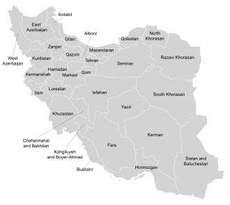
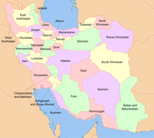
Provinces of Iran
| Provinces of Iran استانهای ایران | |
|---|---|
| |
 | |
| Category | Unitary state |
| Location | Iran |
| Number | 31 |
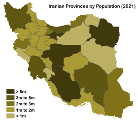
| Populations | 580,158 (Ilam Province) – 13,267,637 (Tehran) |
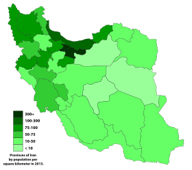
| Areas | 5,833 km2 (2,252 sq mi) (Alborz) – 183,285 km2 (70,767 sq mi) (Kerman Province) |
| Government |
|
| Subdivisions |
|

Legend:


Iran is subdivided into thirty-one provinces (Persian: استان Ostān), each governed from a local centre, usually the largest local city, which is called the capital (Persian: مرکز, markaz) of that province. The provincial authority is headed by a Governor-general (Persian: استاندار Ostāndār), who is appointed by the Minister of the Interior subject to approval of the cabinet.[1]
Modern history[]
Iran has held its modern territory since the Treaty of Paris in 1857. From 1906 until 1950, Iran was divided into twelve provinces: Ardalan, Azerbaijan, Baluchestan, Fars, Gilan, Araq-e Ajam, Khorasan, Khuzestan, Kerman, Larestan, Lorestan, and Mazandaran.[2]
In 1950, Iran was reorganized to form ten numbered provinces with subordinate governorates: Gilan; Mazandaran; East Azerbaijan; West Azerbaijan; Kermanshah; Khuzestan; Fars; Kerman; Khorasan; Isfahan.[2]
Iran has had a historical claim to Bahrain as its 14th province: Bahrain Province, until 1971 under British colonial occupation. Prior to 1957, Bahrain was placed under Fars Province.[3] During Safavid Iran, Bahrain was subordinate to Bushehr governorship and Zubarah (located in modern-day country of Qatar) was its capital city. In 1737, under Afsharid dynasty Bahrain was made subject to Fars governorship.[4] This claim was reasserted by the new theocratic Iranian leadership after 1979 with the famous 1981 coup attempt that occurred.[5]
From 1960 to 1981, the governorates were raised to provincial status one by one. Since then several new provinces have been created, most recently in 2010 when the new Alborz Province was split from Tehran province, and before that in 2004 when the province of Khorasan was divided into three provinces.[6]
Information[]

Current provinces[]
According to Donyaye Eqtesad, between 2017 and 2019, some 11 of the 20 poorest Iranian cities were in the province of Sistan and Baluchestan. Three other markedly poor cities were located in Kerman province. [7]
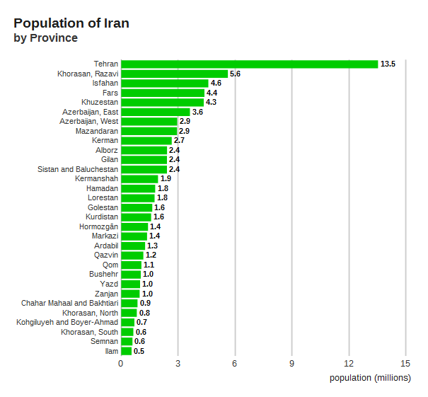
| Province | Capital | Population, 2016[8] | Population 2011 | Annual Population Growth Rate (2006–2016) | Population of the capital city | Capital's share of provincial population | Land Area (km2) | Population Density (people per km2) | Shahrestans (counties) | Life expectancy, male[9] | Life expectancy, female[9] | Notes | Map |
|---|---|---|---|---|---|---|---|---|---|---|---|---|---|
| Alborz | Karaj | 2,712,400 | 2412513 | 3.21% | 1592492 | 58.71% | 5833 | 465.01 | 4 | 74.4 | 78 | Until 23 June 2010, Alborz was part of Tehran province. | 
|
| Ardabil | Ardabil | 1,270,420 | 1248488 | 0.50% | 529374 | 41.67% | 17800 | 71.37 | 9 | 71.3 | 75.6 | Until 1993, Ardabil was part of East Azerbaijan province.[10] | 
|
| Azerbaijan, East | Tabriz | 3,909,652 | 3724620 | 1.08% | 1558693 | 39.87% | 45650 | 85.64 | 19 | 72.5 | 75.9 | 
| |
| Azerbaijan, West | Urmia | 3,265,219 | 3080576 | 1.53% | 793000 | 24.29% | 37437 | 87.22 | 14 | 71.6 | 76.3 | During the Pahlavi Dynasty Urmia was known as Rezaiyeh.[11] | 
|
| Bushehr | Bushehr | 1,163,400 | 1032949 | 3.43% | 223504 | 19.21% | 22743 | 51.15 | 9 | 71 | 73.5 | Originally part of Fars province. Until 1977, the province was known as Khalij-e Fars (Persian Gulf).[2] | 
|
| Chahar Mahaal and Bakhtiari | Shahrekord | 947,763 | 895263 | 1.23% | 190441 | 20.09% | 16332 | 58.03 | 6 | 70.2 | 75 | Until 1973 was part of Isfahan province.[12] | 
|
| Fars | Shiraz | 4,851,274 | 4596658 | 1.49% | 1565572 | 32.27% | 122608 | 39.57 | 23 | 72.1 | 76.3 | 
| |
| Gilan | Rasht | 2,530,696 | 2480874 | 0.63% | 713000 | 28.17% | 14042 | 180.22 | 16 | 72.1 | 76.5 | 
| |
| Golestan | Gorgan | 1,868,819 | 1777014 | 1.73% | 350676 | 18.77% | 20195 | 92.53 | 11 | 70.8 | 74.2 | On the 31 May 1997, the shahrestans of Aliabad, Gonbad-e-kavus, Gorgan, Kordkuy, Minudasht, and Torkaman were separated from Mazandaran province to form Golestan province. Gorgan was called Esteraba or Astarabad until 1937.[2] | 
|
| Hamadan | Hamadan | 1,738,234 | 1738214 | 0.50% | 554405 | 31.53% | 19368 | 90.78 | 8 | 71.2 | 75.6 | Originally part of Kermanshah province.[2] | 
|
| Hormozgān | Bandar Abbas | 1,776,415 | 1578183 | 3.01% | 526648 | 29.65% | 70669 | 25.14 | 11 | 69.9 | 73.7 | Originally part of Kerman province.[2] Until 1977, the province was known as Banader va Jazayer-e Bahr-e Oman (Ports and Islands of the Sea of Oman).[2] | 
|
| Ilam | Ilam | 580,158 | 557599 | 0.35% | 194030 | 33.44% | 20133 | 28.82 | 7 | 70.5 | 72 | Originally part of Kermanshah province.[2] | 
|
| Isfahan | Isfahan | 5,120,850 | 4879312 | 1.64% | 2132000 | 41.63% | 107029 | 47.85 | 21 | 73 | 77 | In 1986, some parts of Markazi province were transferred to Isfahan, Semnan, and Zanjan provinces.[2] | 
|
| Kerman | Kerman | 3,164,718 | 2938988 | 2.24% | 537718 | 16.99% | 183285 | 17.27 | 14 | 71.4 | 75.5 | 
| |
| Kermanshah | Kermanshah | 1,952,434 | 1945227 | 0.60% | 1026000 | 52.55% | 24998 | 78.10 | 13 | 70.4 | 75.3 | Between 1950 and 1979, both Kermanshah province and city were known as Kermanshahan and between 1979 and 1995 were known as Bakhtaran.[2] | 
|
| Khorasan, North | Bojnourd | 863,092 | 867727 | 0.90% | 228931 | 26.52% | 28434 | 30.35 | 6 | 69.8 | 72.6 | On 29 September 2004, Khorasan was divided into three provinces. North Khorasan; Razavi Khorasan; South Khorasan.[6] | 
|
| Khorasan, Razavi | Mashhad | 6,434,501 | 5994402 | 1.67% | 3208000 | 49.86% | 118884 | 54.12 | 29 | 72.1 | 76.2 | On 29 September 2004, Khorasan was divided into three provinces. North Khorasan; Razavi Khorasan; South Khorasan.[6] | 
|
| Khorasan, South | Birjand | 768,898 | 662534 | 2.80% | 203636 | 26.48% | 151913 | 5.06 | 8 | 70.8 | 73.9 | On 29 September 2004, Khorasan was divided into three provinces. North Khorasan; Razavi Khorasan; South Khorasan.[6] | 
|
| Khuzestan | Ahvaz | 4,710,509 | 4531720 | 1.24% | 1244000 | 26.41% | 64055 | 73.54 | 18 | 71.3 | 73.9 | 
| |
| Kohgiluyeh and Boyer-Ahmad | Yasuj | 713,052 | 658629 | 1.47% | 134532 | 18.87% | 15504 | 45.99 | 5 | 71.2 | 73.1 | Originally part of Khuzestan province. Until 1990, the province was known as Bovir Ahmadi and Kohkiluyeh.[2] | 
|
| Kurdistan | Sanandaj | 1,603,011 | 1493645 | 1.32% | 412767 | 25.75% | 29137 | 55.02 | 9 | 70.6 | 74.1 | Originally part of Gilan province.[2] | 
|
| Lorestan | Khorramabad | 1,760,649 | 1754243 | 0.42% | 373416 | 21.21% | 28294 | 62.23 | 9 | 71.1 | 74.5 | Originally part of Khuzestan province.[2] | 
|
| Markazi | Arak | 1,429,475 | 1413959 | 0.77% | 520944 | 36.44% | 29130 | 49.07 | 10 | 72.9 | 76.7 | Originally part of Mazandaran province.[2] In 1986, some parts of Markazi province were transferred to Isfahan, Semnan, and Zanjan provinces.[2] | 
|
| Mazandaran | Sari | 3,283,582 | 3073943 | 1.35% | 309820 | 9.44% | 23701 | 138.54 | 15 | 73.5 | 77 | 
| |
| Qazvin | Qazvin | 1,273,761 | 1201565 | 1.29% | 402748 | 31.62% | 15549 | 81.92 | 5 | 71.8 | 75.3 | On 31 December 1996, the shahrestans of Qazvin and Takestan were separated from Zanjan province to form the province of Qazvin.[2] | 
|
| Qom | Qom | 1,292,283 | 1151672 | 2.47% | 1288000 | 99.67% | 11526 | 112.12 | 1 | 71.5 | 75.6 | Until 1995, Qom was a shahrestan of Tehran province.[2] | 
|
| Semnan | Semnan | 702,360 | 631218 | 2.30% | 134532 | 19.15% | 97491 | 7.20 | 4 | 73.2 | 76.1 | Originally part of Mazandaran province.[2] In 1986, some parts of Markazi province were transferred to Isfahan, Semnan, and Zanjan provinces.[2] | 
|
| Sistan and Baluchestan | Zahedan | 2,775,014 | 2534327 | 1.81% | 610000 | 21.98% | 180726 | 15.35 | 8 | 65.7 | 69.2 | Until 1986, the province was known as Baluchestan and Sistan.[2] | 
|
| Tehran | Tehran | 13,267,637 | 12183391 | 1.82% | 9135000 | 68.85% | 18814 | 705.20 | 13 | 74.3 | 77.8 | Until 1986, Tehran was part of Markazi province. | 
|
| Yazd | Yazd | 1,138,533 | 1074428 | 1.88% | 529673 | 46.52% | 76469 | 14.89 | 10 | 73.2 | 76.7 | Originally part of Isfahan province.[12] In 1986, part of Kerman province was transferred to Yazd province. In 2002, Tabas shahrestan (area: 55,344 km2) was transferred from Khorasan province to Yazd.[2] | 
|
| Zanjan | Zanjan | 1,057,461 | 1015734 | 1.22% | 430871 | 40.75% | 21773 | 48.57 | 7 | 73.2 | 75.8 | Originally part of Gilan province. In 1986, some parts of Markazi province were transferred to Isfahan, Semnan, and Zanjan provinces.[2] | 
|
| Iran (Total) | Tehran | 79,926,270 | 75129615 | 1.55% | 31654423 | 40% | 1,628,554 km2 (628,788 sq mi) | 49.078 | 342 | 72.5 | 75.9 | 
|
Historical provinces[]
- Khorasan Province
- Bahrain Province
| ||
|---|---|---|
|  | |
See also Tax Districts of the Achaemenid Empire (according to Herodotus) | ||
Provinces of the Sasanian Empire | ||
|---|---|---|
| ||
* indicates short living provinces | ||
See also[]
- List of current Iran governors-general
- List of Iranian provinces by Human Development Index
- Administrative divisions of Iran
- Regions of Iran
- Counties of Iran
- Geography of Iran
- ISO 3166-2:IR
References and notes[]
- ^ IRNA, Online Edition. "Paris for further cultural cooperation with Iran". Archived from the original on 23 October 2007. Retrieved 21 October 2007.
- ^ a b c d e f g h i j k l m n o p q r s t u v Gwillim Law, Statoids website. "Provinces of Iran". Archived from the original on 22 October 2016. Retrieved 30 April 2006.
- ^ Ebrahimi, Mansoureh; Rad Goudarzi, Masoumeh; Yusoff, Kamaruzaman (2018), The Dynamics of Iranian Borders: Issues of Contention, Springer, p. 106, ISBN 9783319898360
- ^ Mojtahed-Zadeh, Pirouz (2013). Security and Territoriality in the Persian Gulf: A Maritime Political Geography. Routledge. p. 139. ISBN 978-0700710980.
- ^ "Former IRGC General Close To Supreme Leader Khamenei: 'Bahrain Is A Province Of Iran That Should Be Annexed To [It]'". MEMRI. 23 March 2016. Retrieved 15 March 2022.
- ^ a b c d Online edition, Al-Jazeera Satellite Network. "Iran breaks up largest province". Archived from the original on 20 May 2006. Retrieved 30 April 2006.
- ^ Monday, 23 Aug 2021 11:30 (23 August 2021). "Iran Enters A New Economic Era Marked By Poverty | Iran International". Iranintl.com. Retrieved 15 March 2022.
- ^ "National census 2016". amar.org.ir. Archived from the original on 14 March 2017. Retrieved 14 March 2017.[]
- ^ a b 2015–2016 data, Statistical Centre of Iran, Source
- ^ Chamber Society, Iranian. "Ardabil Province". Archived from the original on 12 June 2008. Retrieved 23 July 2008.
- ^ "Urmia". Archived from the original on 8 September 2008. Retrieved 23 July 2008.
- ^ a b Chaharmahal and Bakhtiari Province, Ostandarie. "Chahar Mahaal and Bakhtiari Province". Retrieved 23 July 2008.[permanent dead link]
External links[]
| Wikimedia Commons has media related to Provinces of Iran. |
 Wikimedia Atlas of Iran
- Statistical Centre, Government of Iran
- Iranian Provinces Investment – Trade Promotion Organization of Iran, affiliated to the Ministry of Commerce (Iran)
- "Provinces of Iran". Statoids.
- Official provincial websites
- Ardabil
- East Azarbaijan
- West Azarbaijan
- Bushehr
- Chahar Mahaal and Bakhtiari
- Fars
- Gilan
- Golestan
- Hamadan
- Hormozgan
- Ilam
- Isfahan
- Kerman
- Kermanshah
- North Khorasan
- Razavi Khorasan
- South Khorasan
- Khuzestan
- Kohgiluyeh and Boyer Ahmad
- Kurdistan
- Lorestan
- Markazi
- Mazandaran
- Qazvin
- Qom[permanent dead link]
- Semnan
- Sistan and Baluchestan
- Tehran
- Yazd
- Zanjan
| ||
- Provinces of Iran
- Administrative divisions in Asia
- First-level administrative divisions by country
- Iran geography-related lists
- Lists of administrative divisions
- Subdivisions of Iran