Districts of Brunei
 |
|---|
|
|
| Administrative divisions of Brunei |
|---|
| First-level |
| Second-level |
| Third-level |
| Outside of hierarchy |
Districts (Malay: daerah) are the principal administrative divisions of Brunei. The country is divided into four districts, namely Brunei-Muara, Belait, Tutong and Temburong. Temburong is an exclave; it is physically separated from the three other districts by the Brunei Bay and Malaysian state of Sarawak. Each district has a town as its administrative and main economic centre, with the exception of Brunei-Muara, where Bandar Seri Begawan, apart from being the country's capital city, is also the district's principal centre.
Administration[]
Each district is administered by a District Office (Jabatan Daerah), where District Offices are government departments under the Ministry of Home Affairs. The head of each department is a District Officer (Pegawai Daerah) and appointed by the government.[1]
A district is further divided into mukims, and subsequently each mukim consists of several villages (kampung). Each District Office manages the mukims and villages within its district.
The districts[]
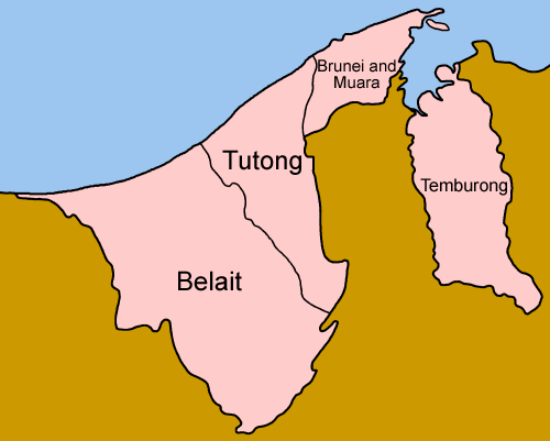
| District | Capital | Population (2016 census)[2] |
Area (km2) |
Area (sq mi) |
Population density (km2) |
No. of mukims |
|---|---|---|---|---|---|---|
| Brunei-Muara | Bandar Seri Begawan (also the capital of Brunei) |
289,630 | 571 | 220 | 507 | 18 |
| Belait | Kuala Belait | 69,062 | 2,727 | 1,053 | 25 | 8 |
| Tutong | Tutong | 48,313 | 1,166 | 450 | 41 | 8 |
| Temburong | Bangar | 10,251 | 1,306 | 504 | 8 | 5 |
See also[]
References[]
- ^ "Brunei Darussalam" (PDF). www.information.gov.bn. p. 44. Retrieved 12 December 2017.
- ^ "Department of Economic Planning and Statistics - Population". www.deps.gov.bn. Retrieved 4 August 2021.
External links[]

This Brunei location article is a stub. You can help Wikipedia by . |
- Subdivisions of Brunei
- Districts of Brunei
- Lists of administrative divisions
- Administrative divisions in Asia
- First-level administrative divisions by country
- Brunei geography-related lists
- Brunei geography stubs