Temburong District
Temburong District
Daerah Temburong دائيره تمبوروڠ | |
|---|---|
    Clockwise from top left: Bangar Town, , a commercial complex in Bangar, a longhouse in Temburong | |
| Nickname(s): Green Jewel of Brunei[1] (Permata Hijau) | |
 | |
| Country | Brunei |
| Town | Bangar |
| Area | |
| • Total | 1,306 km2 (504 sq mi) |
| Population (2016)[3] | |
| • Total | 10,251 |
| • Estimate (2020)[3] | 11,200 |
| • Density | 7.8/km2 (20/sq mi) |
| Time zone | UTC+8 (BNT) |
| Postcode | P |
| Area code | 5 |
| Website | temburong.gov.bn |
Temburong District (Malay: Daerah Temburong) or simply Temburong (Malay: [tǝmburoŋ] (![]() listen)) is the easternmost district in Brunei. It is an exclave — the land is separated from the rest of the country by Malaysia and Brunei Bay, and accessible from the mainland via the Temburong Bridge. It has a total area of 1,306 km2 (504 sq mi).[2] The population was 10,251 in 2016;[3] it the least populous district in the country.[2] Bangar is the district town and administrative centre.
listen)) is the easternmost district in Brunei. It is an exclave — the land is separated from the rest of the country by Malaysia and Brunei Bay, and accessible from the mainland via the Temburong Bridge. It has a total area of 1,306 km2 (504 sq mi).[2] The population was 10,251 in 2016;[3] it the least populous district in the country.[2] Bangar is the district town and administrative centre.
Geography[]
The district is surrounded by Brunei Bay to the north and Sarawak, Malaysia to the east, south and west.
The flows through the district, and the Sungai Pandaruan river forms the western section of the border with Malaysia.
The highest point is Bukit Pagon with the height of 1,850 metres (6,070 ft). It is also the highest point in the country.
Brunei's first national park, the Ulu Temburong National Park, is located south of the Temburong district, covering 550 km2 (210 sq mi) of the Temburong forest. The national park has a scientific research centre facility, the Kuala Belalong Rainforest Field Studies Centre, which is only accessible by boat. 25 hectares (62 acres) of the Kuala Belalong area had been allocated for joint venture research projects conducted by the Universiti Brunei Darussalam, Kuala Belalong Field Studies and the Smithsonian Tropical Research Institute. It is called the "Belalong Rainforest Experience," and is funded by The Hongkong and Shanghai Banking Corporation: Brunei.[4] An Outward Bound centre can also be found within the national park.
Temburong has 67 km (42 mi) of roads connecting Bangar to interior villages. In addition a further 54 km (34 mi) of roads connect villages in the interior.[citation needed]
A new 30 km (19 mi) roadway connecting the Muara and Temburong districts of Brunei was completed in March 2020.[5] 14 km (8.7 mi) of this roadway crosses the Brunei Bay.[6]
Administration[]

The district administration is the responsibility of Temburong District Office (Jabatan Daerah Temburong), a government department under the Ministry of Home Affairs.
Temburong District is divided into five mukims:
Demographics[]
| Census Year | Pop. | ±% |
|---|---|---|
| 1971 | 5,224 | — |
| 1981 | 6,218 | +19.0% |
| 1991 | 7,688 | +23.6% |
| 2001 | 8,563 | +11.4% |
| 2011 | 8,852 | +3.4% |
| 2016 | 10,251 | +15.8% |
| Source: Department of Statistics[7] | ||
Temburong District is the least populous district in Brunei. According to the 2016 census update,[7] the population was 10,251 and made up about 2.5% of the country's total population. 52.2% were males and 47.8% were females. The racial make-up were as follow: 65.7% were Malays, 10.3% were Chinese, and 24% were those other than the aforementioned races. In terms of residency status, 80.7% were citizens, 12% were permanent residents and 7.3% were temporary residents. In terms of professed religions, 73.3% were Muslims, 13% were Christians, 1.3% were Buddhists, and 12.4% professed other than the aforementioned religions or irreligious. The age groups were as follow: 22% were 14 years old and below, 19.1% were 15 to 24 years old, 52.3% were 25 to 64 years old, and 6.5% were 65 years old and above. The population is predominantly rural, whereby 93.9% lived in rural areas in contrast to 6.1% in urban areas.
The census also recorded 2,007 households living in 1,894 dwellings in the district.[7]
In 2020, the district's population was estimated to have increased to 11,200.[3]
Tourism[]
This section contains content that is written like an advertisement. (June 2021) |
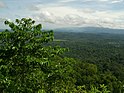
Pristine forest still covers most of the district.[8] This leads to the intensive development of the eco-tourism industry in Temburong district. Eco-Tourism promotion events such as "Cuti-Cuti Temburong" ('Temburong holidays') was launched at the end of 2008 by the local tourism group known as "Kenali Negara Kitani" (KNK) ('Know Your Country') to encourage locals and tourists from foreign countries to travel to the Temburong district.[8] The promotion event is a kick-start of the Heart of Borneo project at Brunei vicinity.
Infrastructures[]
Education[]
In 2019,[9] there were 14 schools in Temburong District under the Ministry of Education, out of which 12 were government and 2 were private. The number of teachers were recorded at 238, in which 91.6% taught in government schools and 8.4% in private schools. The number of students were recorded at 1,816, whereby 90.7% were enrolled in government schools and 9.3% in private schools. For the formal Islamic religious education which is under the Ministry of Religious Affairs, there were 12 religious schools (7.6% of the country's total), employing 106 teachers and enrolling 770 students.
The highest education level available is secondary and provided at Sultan Hassan Secondary School, the sole secondary school in the district.
Healthcare[]
In 1987 the $10 million Pengiran Isteri Hajah Mariam Hospital opened, providing 50 beds and a variety of medical services. A number of village clinics also exist.[citation needed]
Roads[]
As of 2019, the district's road network comprised a total length of 196.73 kilometres (122.24 mi), out of which 67.5% were paved.[9]
The road network is connected to the rest of the country primarily via Sultan Haji Omar Ali Saifuddien Bridge, commonly known as Temburong Bridge, which traverses the Labu Forest Reserve and the Brunei Bay. The other end of the bridge terminates in Brunei-Muara District. There is also the alternative road which crosses the Brunei–Malaysia border and is through the Limbang District in the Malaysian state of Sarawak. Prior to the opening of the bridge in 2020, the route which passes through Malaysia was the only land route to the rest of the country.
Security[]
The district has an army presence at Bangar Camp. There is one main police headquarters in Bangar and numerous police posts around the district.
Use by SAF[]
The SAF Commandos regularly conducts jungle training here. A Singapore army camp is also located in between Kampung Negalang and the other town that is called the Lakiun.
Notes[]
- ^ "The Country's Priceless Green Jewel | Brunei's No.1 News Website". brudirect.com. 25 July 2018. Retrieved 30 June 2021.
- ^ Jump up to: a b c "Temburong District" (PDF). p. 8. Retrieved 17 October 2017.
- ^ Jump up to: a b c d "Department of Economic Planning and Statistics - Population". www.deps.gov.bn. Retrieved 30 June 2021.
- ^ Rasidah, H.A.B. (4 April 2009). "Project for in-depth study of local forests". The Brunei Times. Archived from the original on 9 April 2009.
- ^ Abu Bakar, Rasidah (16 March 2020). "Temburong bridge opens to traffic today". The Scoop. Archived from the original on 19 March 2020. Retrieved 20 March 2020.
- ^ Rabiatul, Kamit (10 May 2013). "Temburong bridge ready 2018". Brunei Times. Archived from the original on 3 December 2013. Retrieved 10 July 2013.
- ^ Jump up to: a b c "Population and Housing Census Update Final Report 2016" (PDF). www.deps.gov.bn. Department of Statistics. December 2018. Retrieved 1 August 2021.
- ^ Jump up to: a b "Exploring Brunei in 'Cuti-Cuti Temburong". The Brunei Times. 6 December 2008. Archived from the original on 24 November 2009.
- ^ Jump up to: a b BRUNEI DARUSSALAM STATISTICAL YEARBOOK 2019 (PDF). Department of Economic Planning and Statistics. 2020. ISBN 9789991772264. Retrieved 2 August 2021.
References[]
- R. Hédl, M. Svátek, M. Dancak, Rodzay A.W., M. Salleh A.B., Kamariah A.S. A new technique for inventory of permanent plots in tropical forests: a case study from lowland dipterocarp forest in Kuala Belalong, Brunei Darussalam, In Blumea 54, 2009, p 124–130. Publié 30. 10. 2009.
External links[]
| Wikimedia Commons has media related to Temburong. |

- Temburong District
- Districts of Brunei
- Enclaves and exclaves
- Brunei–Malaysia border