Mukim Amo
Mukim Amo | |
|---|---|
| Country | Brunei |
| District | Temburong |
| Area | |
| • Total | 542 km2 (209 sq mi) |
| Population (2016)[2] | |
| • Total | 2,144 |
| • Density | 4.0/km2 (10/sq mi) |
| Time zone | UTC+8 (BNT) |
| Postcode | PDxx51 |
Mukim Amo is a mukim in Temburong District, Brunei. Mukim Amo has an area of 542 square kilometres (209 sq mi);[1] as of 2016, it had a total population of 2,144.[2]
Name[]
The mukim is named after Kampong Amo, one of the villages it encompasses.[citation needed]
Geography[]
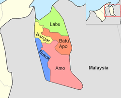
The mukim is located in the eastern part of the district,[1] bordering Mukim Batu Apoi to the north-east, Mukim Bokok to the west and Mukim Bangar to north-west, as well as the Malaysian state of Sarawak to the east and south.
Demographics[]
As of ,[2] the population of Mukim Amo comprised 1,126 males and 1,018 females. The mukim had 421 households occupying 377 dwellings. The entire population lived in rural areas.
Villages[]
Mukim Amo comprises the following populated villages:[2]
References[]
- ^ Jump up to: a b c "Jabatan Daerah Temburong, Kementerian Hal Ehwal Dalam Negeri - MUKIM AMO". temburong.gov.bn (in Malay). Retrieved 2018-01-08.
- ^ Jump up to: a b c d "Population and Housing Census Update Final Report 2016" (PDF). www.deps.gov.bn. Statistics Department. December 2018. Retrieved 27 June 2021.
External links[]
This Brunei location article is a stub. You can help Wikipedia by . |
- Mukims in Brunei
- Temburong District
- Brunei geography stubs