Mukim Bangar
Mukim Bangar | |
|---|---|
| Country | Brunei |
| District | Temburong |
| Area | |
| • Total | 113 km2 (44 sq mi) |
| Population (2016)[2] | |
| • Total | 2,449 |
| • Density | 22/km2 (56/sq mi) |
| Time zone | UTC+8 (BNT) |
| Postcode | PAxx51 |
Mukim Bangar is a mukim in Temburong District, Brunei. It has a total area of 113 square kilometres (44 sq mi);[1] as of 2016, the population was 2,449.[2] The mukim encompasses Bangar, the district's sole town and administrative centre.
Name[]
The mukim is named after the town Bangar, which is also the predominant settlement it encompasses.[citation needed]
Geography[]
The mukim is located in the north-west of the Temburong District, bordering Mukim Labu to the north, Mukim Batu Apoi to the east, Mukim Amo to the south-east, Mukim Bokok to the south-west and Limbang District in the Malaysian state of Sarawak to the west and north. Mukim Bangar has one island within its vicinity which is Pulau Kibi.
Demographics[]
As of ,[2] the population of Mukim Bangar comprised 1,322 males and 1,127 females. The mukim had 535 households occupying 515 dwellings. Among the population, 626 lived in urban areas, while the remainder of 1,823 lived in rural areas.
Villages[]
Mukim Bangar consists of the following populated villages:[2]
- Bangar, town proper
- Bangar Camp (Perkemahan Bangar)
- Kampong Bang Bulan
- Kampong Batang Tuau
- Kampong Batu Bejarah
- Kampong Belingos
- Kampong Gadong
- Kampong Kinalong
- Kampong Lagau
- Kampong Parit Belayang
- Kampong Piungan
- Kampong Puni
- Kampong Semamang
- Kampong Seri Tanjong Belayang
- Kampong Sungai Tanam
- Kampong Sungai Tanit
- Kampong Sungai Sulok
- Kampong Ujong Jalan
Other locations[]
Other locations within the mukim include:
- Pulau Kibi
Border crossings[]
This section does not cite any sources. (June 2021) |
There is a road border crossing into Malaysia's Sarawak state at Kampung Ujung Jalan, 5km from Bangar town. Previously the crossing had to be done by vehicular ferry across the Pandaruan River which forms the Brunei-Malaysia border. However, a Malaysia-Brunei Friendship Bridge had been constructed and opened to vehicular traffic on 8 December 2013.
Both Brunei and Malaysia have constructed new customs, immigration and quarantine checkpoints at the location of the crossing. The Brunei checkpoint is called the Ujung Jalan Immigration Checkpoint. Before the construction of the bridge, the Brunei customs, immigration and quarantine checkpoint was housed in a wooden building in Kampung Puni, 500m from the ferry landing towards Bangar, while Malaysian customs and immigration procedures had to be carried out at Limbang wharf in Limbang, 15km away as there was no checkpoint at Pandaruan.
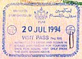
Old Brunei entry stamp from the Puni border checkpoint before the opening of the Ujung Jalan checkpoint.

Ujung Jalan checkpoint exit stamp.


References[]
- ^ Jump up to: a b "Jabatan Daerah Temburong, Kementerian Hal Ehwal Dalam Negeri - MUKIM BANGAR". temburong.gov.bn (in Malay). Retrieved 9 January 2018.
- ^ Jump up to: a b c d "Population and Housing Census Update Final Report 2016" (PDF). www.deps.gov.bn. Statistics Department. December 2018. Retrieved 27 June 2021.
Coordinates: 4°42′30″N 115°4′25″E / 4.70833°N 115.07361°E

This Brunei location article is a stub. You can help Wikipedia by . |
- Mukims in Brunei
- Temburong District
- Brunei–Malaysia border crossings
- Brunei geography stubs