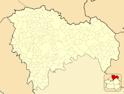
Anguita
This article does not cite any sources. (October 2012) |
Anguita | |
|---|---|
 | |
 Coat of arms | |
 Anguita Location in Spain | |
| Coordinates: 41°01′33″N 2°22′07″W / 41.02583°N 2.36861°W | |
| Country | |
| Autonomous community | Castile-La Mancha |
| Province | Guadalajara |
| Comarca | |
| Judicial district | Sigüenza |
| Government | |
| • Mayor | Claudio Sancho González (PSOE) |
| Area | |
| • Total | 127.19 km2 (49.11 sq mi) |
| Elevation | 1,107 m (3,632 ft) |
| Population (2018)[1] | |
| • Total | 163 |
| • Density | 1.3/km2 (3.3/sq mi) |
| Demonym(s) | Anguiteños |
| Time zone | UTC+1 (CET) |
| • Summer (DST) | UTC+2 (CEST) |
| Postal code | 19283 |
Anguita is a municipality in the province of Guadalajara, Castile-La Mancha, Spain, with a population of 203 in 2009.
Geography[]
Anguita is located in the Sistema Ibérico below . River Tajuña and its tributaries, and flow through the area.
The municipality includes the towns of , Anguita, , and .
There is an important population of Dupont's lark (Chersophilus duponti) in the surrounding area.
History[]
Anguita's area has been populated since ancient times. Anguita has remains of a Roman camp, although it is possible that it has been a Celtiberian city before.
During the al-Andalus period, Anguita was located on the frontier with the northern Christian-held territory.
In 1813 the first of Spain was signed here.
Main sights[]
- Cigüeña Tower.
- Remains of the Roman camp
- and some others ruins, such as those of , where is the biggest necropolis of this culture, "El Altillo".
- Saint Peter Church, a Romanesque-Gothic church.
- Virgen de la Lastra hermitage, the biggest church in the village.
- La Soledad hermitage, a typical local hermitage.
References[]
- ^ Municipal Register of Spain 2018. National Statistics Institute.
External links[]
| Wikimedia Commons has media related to Anguita. |
- "Diputación de Guadalajara". Archived from the original on 2012-12-11. Retrieved 2010-02-01.
- Situation
- Information of the village from "Castilla-La Mancha: descubre y siente"
Categories:
- Municipalities in the Province of Guadalajara


