Annan District
Coordinates: 23°02′50″N 120°11′05″E / 23.0473013°N 120.1846813°E
Annan
安南區 | |
|---|---|
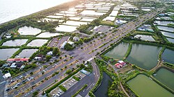
 Coastal landscape in Annan District | |
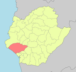
 Annan District in Tainan City | |
| Location | Tainan, Taiwan |
| Area | |
| • Total | 107 km2 (41 sq mi) |
| Population (July 2018) | |
| • Total | 192,887 |
| • Density | 1,800/km2 (4,700/sq mi) |
| Website | www |

Annan District (Chinese: 安南區; pinyin: Ānnán Qū; Wade–Giles: An1-Nan2 Ch'ü1; Pe̍h-ōe-jī: An-Lâm-Khu) is a coastal district located in the west of Tainan, Taiwan.
History[]
After the handover of Taiwan from Japan to the Republic of China in 1945, Anshun was organized as a rural township of Tainan County. In 1946, the township was incorporated into Tainan City and became Annan District.[1]
Geography[]
- Area: 107.20 km2
- Population: 189,724 people (January 2016)
Administrative divisions[]
The district consists of Tunghe, Anshun, Wennan, Zhounan, Zhoubei, Antung, Anx, Dingan, Anqing, Xinshun, Yuandian, Zongtou, Zhangan, Gongqin, Haitung, Haixi, Hainan, Xixin, Gongwen, Yuantung, Yuanxi, Diantung, Dianxi, Yantian, Nanxing, Xuetung, Chengtung, Chengbei, Chengzhong, Chengnan, Chengxi, Jingcao, Shalun, Xiangong, Luer, Sicao, Anhe, Xibei, Xiding, Xiqi, Haidian, Xingfu, Fenghuang, Meihua, Lixiang, Xitung, Yuanzhong, Budai, Guoan, Anfu and Daan Village.[2][failed verification]
Education[]
Tourist attractions[]

- Luerhmen History and Culture Museum
- National Museum of Taiwan History
- Sicao Fortress
- Sicao Wetlands
- Southwest Coast National Scenic Area
- Taijiang National Park
- Taikang Cultural Center
Notable natives[]
- Shih Chih-ming, Mayor of Tainan (1989–1997)
See also[]
References[]
- ^ "The History of the District Name". Annan District Office, Tainan City. Retrieved 2021-06-05.
- ^ https://web.archive.org/web/20181129142003/https://www.cec.gov.tw/pc/en/CV/m67000003500000000.html. Archived from the original on 2018-11-29. Retrieved 2018-11-29. Missing or empty
|title=(help)
External links[]
| Wikimedia Commons has media related to Annan District, Tainan. |
- Official website

- Luerhmen (in Chinese)
- Districts of Tainan
