Annanhead Hill
| Annanhead Hill | |
|---|---|
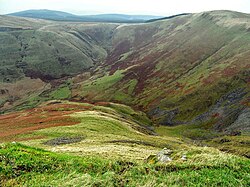 Annanhead Hill above Devils Beef Tub | |
| Highest point | |
| Elevation | 478 m (1,568 ft)[1][2] |
| Coordinates | 55°24′15″N 3°29′19″W / 55.40417°N 3.48861°WCoordinates: 55°24′15″N 3°29′19″W / 55.40417°N 3.48861°W[2] |
| Geography | |
| Location | 9 km north of Moffat |
| Parent range | Moffat Hills |
| OS grid | NT 05834 13251 |


Annanhead Hill trig point (S5678)
Annanhead Hill is a 478-metre (1,568 ft) summit in the Moffat Hills of Scotland. It lies on the boundary between the Scottish Borders and Dumfries and Galloway, 9 kilometres (5.6 mi) north of Moffat, in the Southern Uplands.[1]
Annanhead is one of four hills encircling the Devil's Beef Tub, the headwaters of River Annan.[3]
The hill is crossed by Annandale Way hiking trail designated in 2009.[4]
References[]
- ^ a b Annanhead Hill, Gazetteer for Scotland
- ^ a b Annanhead Hill, Trigpointing UK
- ^ Louisa Finch (April 1, 2013), "The big picture: The Devil's Beef Tub", Scotland Outdoors, archived from the original on April 7, 2013, retrieved May 14, 2013
- ^ "Route description: Moffat - Devils Beef Tub - Moffat", Annandale Way official website, Government of Scotland et al., retrieved 2013-05-14,
The Devil's Beef Tub section of this walk ... climb[s] onto Annanhead Hill and a range that rims the upper limits of the Annan catchment. ...
External links[]
 Media related to Annanhead Hill at Wikimedia Commons
- The Moffat Hills at Summitpost.com
Categories:
- Mountains and hills of the Southern Uplands
- Mountains and hills of Dumfries and Galloway
- Mountains and hills of the Scottish Borders