Anza (river)
| Anza | |
|---|---|
 Location within NE Piedmont | |
| Location | |
| Country | Italy |
| Physical characteristics | |
| Source | |
| • location | Macugnaga, Belvedere Glacier |
| • elevation | 1,800 m (5,900 ft) |
| Mouth | Toce |
• coordinates | 46°00′53″N 8°16′57″E / 46.0148°N 8.2825°ECoordinates: 46°00′53″N 8°16′57″E / 46.0148°N 8.2825°E |
| Length | 35 km (22 mi) |
| Basin features | |
| Progression | Toce→ Lake Maggiore→ Ticino→ Po→ Adriatic Sea |
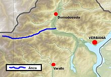
The Anza is a 35-kilometre (22 mi) Alpine torrent of the Ossola in northern Italy. It flows from the glaciers of Monte Rosa through the Valle Anzasca and into the river Toce, of which it is a right tributary.
Its own principal tributaries are the , the , the and the near Macugnaga and the at Bannio Anzino.
Sources[]
- This original version of this article included text translated from its counterpart in the Italian Wikipedia.
This article on a location in the Province of Verbano-Cusio-Ossola is a stub. You can help Wikipedia by . |
Categories:
- Tributaries of the Toce
- Rivers of Italy
- Rivers of the Province of Verbano-Cusio-Ossola
- Rivers of the Alps
- Province of Verbano-Cusio-Ossola geography stubs
- Italy river stubs