Toce
| Toce | |
|---|---|
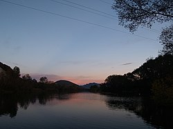 The river at its confluence with the Strona | |
 Course of the Toce | |
| Location | |
| Country | Italy, Switzerland |
| Physical characteristics | |
| Source | |
| • location | |
| Mouth | Lake Maggiore |
• coordinates | 45°56′11″N 8°29′36″E / 45.9365°N 8.4932°ECoordinates: 45°56′11″N 8°29′36″E / 45.9365°N 8.4932°E |
| Length | 83.6 km (51.9 mi)[1] |
| Discharge | |
| • average | 69.9 m3/s (2,470 cu ft/s)[2] |
| Basin features | |
| Progression | Lake Maggiore→ Ticino→ Po→ Adriatic Sea |

The Toce (Italian pronunciation: [ˈtoːtʃe; ˈtɔːtʃe]) is a river in Piedmont, Italy, which stretches the length of the Val d'Ossola from the Swiss border to Lake Maggiore into which it debouches near in the commune of Verbania. The river is 83.6 kilometres (51.9 mi) long[1] and is formed in the upper by the confluence of a number of torrents in the plain of Riale.
Geography[]

The source of one of these, the Gries, is situated on the Italian southern side of the Gries Pass; another forms beneath the Passo di San Giacomo, others flow from little Alpine lakes such as Lago Castel and Lago di Sabbione.
South of the water of the river plummets 143 metres (469 ft) over the Cascata del Toce into the , through which it flows before transversing Valle Antigorio after another series of cascades. Near Crevola d'Ossola the river Diveria flows into the Toce. At this point, the valley gets wider and is known as Val d'Ossola. The Toce flows next to the capital of the valley, Domodossola, and then Villadossola and Ornavasso. After a total of 76 kilometres (47 mi) the Toce then flows into Lake Maggiore. The major tributaries are the Diveria, , Melezzo Occidentale (joining it near Domodossola), , Anza (near Piedimulera), and the Strona (near Gravellona Toce).
History[]
In ancient times the Toce river was called Athisone or Atisone, from which the current name is derived. An old alternative spelling is also La Toccia (with feminine gender).
Notes[]
- ^ Jump up to: a b Caratterizzazione bacini Idrografici (elab.I.a/5) - Allegato tecnico al Piano di Tutela delle Acque Archived 2012-02-25 at the Wayback Machine (Regione Piemonte, 1 July 2004).
- ^ AA.VV. (2004). "Elaborato I.c/7". Piano di Tutela delle Acque - Revisione del 1º luglio 2004; Caratterizzazione bacini Idrografici (PDF). Regione Piemonte. Archived from the original (PDF) on 2012-02-25. Retrieved 2014-01-07.
![]() Media related to Toce at Wikimedia Commons
Media related to Toce at Wikimedia Commons
| hide | ||
|---|---|---|
| ||
| Settlements |
|  |
| Islands | ||
| Rivers | ||
| Landmarks | ||
| Films | ||
| People | ||
- Tributaries of Lake Maggiore
- Toce
- Rivers of the Alps