Ap Lei Pai
鴨脷排 | |
|---|---|
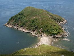 Ap Lei Pai Island as seen from Ap Lei Chau Island. A tombolo connects the two islands. | |
| Geography | |
| Coordinates | 22°13′50.5554″N 114°9′40.4994″E / 22.230709833°N 114.161249833°ECoordinates: 22°13′50.5554″N 114°9′40.4994″E / 22.230709833°N 114.161249833°E |
| Adjacent bodies of water | East Lamma Channel Aberdeen Channel |
| Administration | |
| District | Southern District |
| Demographics | |
| Population | Uninhabited |

| Ap Lei Pai | |||||||||
|---|---|---|---|---|---|---|---|---|---|
| Traditional Chinese | 鴨脷排 | ||||||||
| |||||||||

Ap Lei Pai viewed from the Tombolo.

Ap Lei Pai (left) and Ap Lei Chau (right); taken from Ocean Park. Lamma Island is visible in the background.
Ap Lei Pai or Aberdeen Rock is an uninhabited island in Hong Kong, linked to the south of Ap Lei Chau in Hong Kong. It is located between the East Lamma Channel and Aberdeen Channel. It is under the administration of the Southern District.
See also[]
External links[]
| Wikimedia Commons has media related to Ap Lei Pai. |
This Hong Kong Island location article is a stub. You can help Wikipedia by . |
Categories:
- Ap Lei Chau
- Southern District, Hong Kong
- Tidal islands
- Tombolos
- Uninhabited islands of Hong Kong
- Hong Kong Island geography stubs