Apetina
Apetina
Pïlëuwimë | |
|---|---|
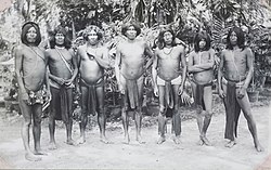 Captain Apetina Curiel with company (1937) | |
 Apetina Location in Suriname | |
| Coordinates: 3°30′37″N 55°3′7″W / 3.51028°N 55.05194°W | |
| Country | Suriname |
| District | Sipaliwini District |
| Resort (municipality) | Tapanahony |
| Government | |
| • Granman | Aptuk Noewahe |
| • Captain | Japanale |
| • Captain | Meteli |
| Population (2020) | |
| • Total | 324[1] |

Apetina, also known as Pïlëuwimë or Puleowime, is a village in the South Eastern jungle area of Suriname within the Tapanahony resort in the Sipaliwini District. It is located at 3°30′N 55°04′W / 3.500°N 55.067°WCoordinates: 3°30′N 55°04′W / 3.500°N 55.067°W in the jungle on the small hills along the river Tapanahoni. Nearby points include Tebu Mountain, at around 347 m (1,138 ft) in height, and the waterfall. The majority of Apetina's population is the Wayana people. These Indians mostly originate from Brazil and once have fled because of tribal warfare. There also is primary school and an airstrip located near the Indian village of Apetina. [2]
Geography[]
| Year | Pop. | ±% p.a. |
|---|---|---|
| 1965 | 106 | — |
| 1969 | 117 | +2.50% |
| 1970 | 122 | +4.27% |
| 2006 | 262 | +2.15% |
| Source: Boven 2006, pp. 103, 106 (1965–1970) Heemskerk et al. 2007, p. 21 (2006) | ||
Apetina lies about 13.5 kilometres (8.4 mi) upstream the Tapanahony river from the village of Tutu Kampu and about 2 kilometres (1.2 mi) downstream the river from the village of Akani Pata. The Apetina Airstrip lies in between the villages of Apetina and Akani Pata.
Notes[]
- ^ "Dorpen en Dorpsbesturen". Vereniging van Inheemse Dorpshoofden in Suriname (in Dutch). Retrieved 4 February 2020.
- ^ Website Apetina.org
References[]
- Boven, Karin M. (2006). Overleven in een Grensgebied: Veranderingsprocessen bij de Wayana in Suriname en Frans-Guyana (PDF). Amsterdam: Rozenberg Publishers.
- Heemskerk, Marieke; Delvoye, Katia; Noordam, Dirk; Teunissen, Pieter (2007). Wayana Baseline Study: A sustainable livelihoods perspective on the Wayana Indigenous Peoples living in and around Puleowime (Apetina), Palumeu, and Kawemhakan (Anapaike) in Southeast Suriname (PDF). Paramaribo: Stichting Amazon Conservation Team-Suriname.
This Suriname location article is a stub. You can help Wikipedia by . |
- Indigenous villages in Suriname
- Populated places in Sipaliwini District
- Suriname geography stubs