Districts of Suriname
 |
|---|
| Constitution |
|
Suriname is divided into 10 districts (Dutch: districten).
Overview[]
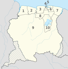
| District | Capital | Area (km2) | Area (%) | Population (2012 census)[1] |
Population (%) | Pop. dens. (inhabitants/km2) | |
|---|---|---|---|---|---|---|---|
| SURINAME | Paramaribo | 163,820 | 100.0 | 541,638 | 100.0 | 3.3 | |
| 1 | Nickerie | Nieuw-Nickerie | 5,353 | 3.3 | 34,233 | 6.3 | 6.4 |
| 2 | Coronie | Totness | 3,902 | 2.4 | 3,391 | 0.6 | 0.9 |
| 3 | Saramacca | Groningen | 3,636 | 2.2 | 17,480 | 3.2 | 4.8 |
| 4 | Wanica | Lelydorp | 443 | 0.3 | 118,222 | 21.8 | 266.9 |
| 5 | Paramaribo | Paramaribo | 182 | 0.1 | 240,924 | 44.5 | 1323.8 |
| 6 | Commewijne | Nieuw-Amsterdam | 2,353 | 1.4 | 31,420 | 5.8 | 13.4 |
| 7 | Marowijne | Albina | 4,627 | 2.8 | 18,294 | 3.4 | 4.0 |
| 8 | Para | Onverwacht | 5,393 | 3.3 | 24,700 | 4.6 | 4.6 |
| 9 | Sipaliwini | none | 130,567 | 79.7 | 37,065 | 6.8 | 0.3 |
| 10 | Brokopondo | Brokopondo | 7,364 | 4.5 | 15,909 | 2.9 | 2.2 |
History[]
The country was first divided up into subdivisions by the Dutch on October 8, 1834, when a Royal Decree declared that there were to be 8 divisions and 2 districts:[2]
- Upper Suriname and Torarica
- Para
- Upper Commewijne
- Upper Cottica and Perica
- Lower Commewijne
- Lower Cottica
- Matapica
- Saramacca
- Coronie (district)
- Nickerie (district)
The divisions were areas near the capital city, Paramaribo, and the districts were areas further away from the city.
In 1927, Suriname's districts were revised, and the country was divided into 7 districts. In 1943, 1948, 1949, 1952 and 1959 further small modifications were made. On October 28, 1966, the districts were redrawn again, into[3]
- Nickerie
- Coronie
- Saramacca
- Brokopondo
- Para
- Suriname
- Paramaribo
- Commewijne
- Marowijne
These divisions remained until 1980, when yet again, the borders of the districts were redrawn, however, with the following requirements:
- Changes in the old boundaries were made only if it leads to improved functioning
- Each area should be developed
- The new boundaries should respect the identities of indigenous people.
The last changes to the districts were in 1985.[3]
See also[]
- ISO 3166-2:SR
- Resorts of Suriname
- List of Caribbean First-level Subdivisions by Total Area
References[]
- ^ Suriname at GeoHive
- ^ "Beknopte aardrijkskundige beschrijving van Suriname" (PDF). Boeroes. 1898. Retrieved 30 May 2020.
- ^ Jump up to: a b "Suriname Districts".
External links[]
- "Districts of Suriname". Statoids.

| show Administrative divisions of the Americas |
|---|

This Suriname location article is a stub. You can help Wikipedia by . |
- Districts of Suriname
- Subdivisions of Suriname
- Lists of administrative divisions
- First-level administrative divisions by country
- Suriname geography-related lists
- Suriname geography stubs