Departments of Colombia
This article includes a list of general references, but it lacks sufficient corresponding inline citations. (March 2009) |
| Capital district and Colombian regions Distrito Capital y los Departamentos de Colombia (Spanish) | |
|---|---|
  | |
| Category | Unitary state |
| Location | Republic of Colombia |
| Number | 32 Departments 1 Capital District |
| Populations | (Departments only):40,797 (Vaupés) – 6,407,102 (Antioquia) |
| Areas | (Departments only):50 km2 (19.3 sq mi) (San Andrés) – 109,665.0 km2 (42,341.89 sq mi) (Amazonas) |
| Government |
|
| Subdivisions |
|
 |
|---|
|
Colombia is a unitary republic made up of thirty-two departments (Spanish: departamentos, sing. departamento) and a Capital District (Distrito Capital).[1] Each department has a governor (gobernador) and an Assembly (Asamblea Departamental), elected by popular vote for a four-year period. The governor cannot be re-elected in consecutive periods. Departments are country subdivisions and are granted a certain degree of autonomy.
Departments are formed by a grouping of municipalities (municipios, sing. municipio). Municipal government is headed by mayor (alcalde) and administered by a municipal council (concejo municipal), both of which are elected for four-year periods.
Some departments have subdivisions above the level of municipalities, commonly known as provinces.
Chart of departments[]
Each one of the departments of Colombia in the map below links to a corresponding article. Current governors serving four-year terms from 2015 to 2019 are also shown, along with their respective political party or coalition.
| ID | Region | Governor | Party | Capital | Area (km²) | Population | Density per km2 |
Established | Flag | Code |
|---|---|---|---|---|---|---|---|---|---|---|
| 00 | Capital District | Claudia López Hernández | Green | Bogotá | 1,587 | 7,412,566 | 4670.80 | 1538 | DC | |
| 01 | Amazonas | Jesús Galindo Cedeño | Coalición 'Juntos por el Amazonas' | Leticia | 109,665 | 76,589 | 0.7 | 1991 | AM | |
| 02 | Antioquia | Aníbal Gaviria | Coalición 'Es el Momento de Antioquia' | Medellín | 63,612 | 6,407,102 | 100.72 | 1826 | AN | |
| 03 | Arauca | José Facundo Castillo | Coalición 'Unidos por Arauca' | Arauca | 23,818 | 262,174 | 11.01 | 1991 | AR | |
| 04 | Atlántico | Elsa Noguera | Coalición 'La Clave es la Gente' | Barranquilla | 3,388 | 2,535,517 | 748.38 | 1910 | AT | |
| 05 | Bolívar | Vicente Antonio Blel | Conservative | Cartagena | 25,978 | 2,070,110 | 79.69 | 1857 | BL | |
| 06 | Boyacá | Ramiro Barragán Adame | Green | Tunja | 23,189 | 1,217,376 | 52.50 | 1539 | BY | |
| 07 | Caldas | Luis Carlos Velásquez | Coalición 'Unidos por Caldas' | Manizales | 7,888 | 998,255 | 126.55 | 1905 | CL | |
| 08 | Caquetá | Arnulfo Gasca Trujillo | Conservative | Florencia | 88,965 | 401,849 | 4.52 | 1982 | CQ | |
| 09 | Casanare | Salomón Andrés Sanabria | CD | Yopal | 44,640 | 420,504 | 9.42 | 1991 | CS | |
| 10 | Cauca | Elías Larrahondo Carabalí | Coalición 'Porque Sí es Posible' | Popayán | 29,308 | 1,464,488 | 49.97 | 1857 | CA | |
| 11 | Cesar | Luis Alberto Monsalvo Gnecco | Coalición 'Alianza por el Cesar' | Valledupar | 22,905 | 1,200,574 | 52.42 | 1967 | CE | |
| 12 | Chocó | Ariel Palacios Calderón | Coalición 'Generando Confianza por un Mejor Chocó' | Quibdó | 46,530 | 534,826 | 11.49 | 1947 | CH | |
| 13 | Córdoba | Orlando David Benítez | Liberal | Montería | 25,020 | 1,784,783 | 71.33 | 1952 | CO | |
| 14 | Cundinamarca | Nicolás García Bustos | Coalición 'Gran Cundinamarca' | Bogotá | 24,210 | 2,919,060 | 120.57 | 1857 | CU | |
| 15 | Guainía | Juan Carlos Iral Gómez | De La U | Inirida | 72,238 | 48,114 | 0.67 | 1963 | GN | |
| 16 | Guaviare | Heydeer Yovanny Palacio | CR | San José del Guaviare | 53,460 | 82,767 | 1.55 | 1991 | GV | |
| 17 | Huila | Luis Enrique Dussán | Coalición 'Huila Crece' | Neiva | 19,890 | 1,100,386 | 55.32 | 1905 | HU | |
| 18 | La Guajira | Nemesio Roys Garzón | Coalición 'Un Cambio por La Guajira' | Riohacha | 20,848 | 880,560 | 42.24 | 1965 | LG | |
| 19 | Magdalena | Carlos Caicedo | G.S.C. Fuerza Ciudadana - Magdalena | Santa Marta | 23,188 | 1,341,746 | 57.86 | 1824 | MA | |
| 20 | Meta | Juan Guillermo Zuluaga | De La U | Villavicencio | 85,635 | 1,039,722 | 12.14 | 1960 | ME | |
| 21 | Nariño | Jhon Alexander Rojas | Coalición 'Mi Nariño' | Pasto | 33,268 | 1,630,592 | 49.01 | 1904 | NA | |
| 22 | Norte de Santander | Silvano Serrano Guerrero | Conservative | Cúcuta | 21,658 | 1,491,689 | 68.87 | 1910 | NS | |
| 23 | Putumayo | Buanerges Rosero | Coalición 'Así es el Putumayo, Tierra de Paz' | Mocoa | 24,885 | 348,182 | 13.99 | 1991 | PU | |
| 24 | Quindío | Roberto Jairo Jaramillo | Liberal | Armenia | 1,845 | 539,904 | 292.63 | 1966 | QD | |
| 25 | Risaralda | Sigifredo Salazar Osorio | Conservative | Pereira | 4,140 | 943,401 | 227.87 | 1966 | RI | |
| 26 | San Andrés y Providencia | Everth Julio Hawkins | Coalición 'Todos por un Nuevo Comienzo' | San Andrés | 52 | 61,280 | 1178.46 | 1991 | SA | |
| 27 | Santander | Mauricio Aguilar | Coalición 'Siempre Santander' | Bucaramanga | 30,537 | 2,184,837 | 71.55 | 1857 | ST | |
| 28 | Sucre | Héctor Olimpo Espinosa | Liberal | Sincelejo | 10,917 | 904,863 | 82.89 | 1966 | SU | |
| 29 | Tolima | José Ricardo Orozco | Conservative | Ibagué | 23,562 | 1,330,187 | 56.45 | 1886 | TO | |
| 30 | Valle del Cauca | Clara Luz Roldán | Coalición 'Todos por el Valle del Cauca' | Cali | 22,140 | 4,475,886 | 202.16 | 1910 | VC | |
| 31 | Vaupés | Elícer Pérez | CD | Mitú | 54,135 | 40,797 | 0.75 | 1991 | VP | |
| 32 | Vichada | Álvaro Arley León | Coalición 'Álvaro León Sabe Como Es' | Puerto Carreño | 100,242 | 107,808 | 1.08 | 1991 | VD |
Indigenous territories[]
The indigenous territories are at the third level of administrative division in Colombia, as are the municipalities. Indigenous territories are created by agreement between the government and indigenous communities. In cases where indigenous territories cover more than one department or municipality, local governments jointly administer them with the indigenous councils, as set out in Articles 329 and 330 of the Colombian Constitution of 1991. Also indigenous territories may achieve local autonomy if they meet the requirements of the law.
Article 329 of the 1991 constitution recognizes the collective indigenous ownership of indigenous territories and repeats that are inalienable. Law 160 of 1994 created the National System of Agrarian Reform and Rural Development Campesino, and replaced Law 135 of 1961 on Agrarian Social Reform; it establishes and sets out the functions of INCORA, one of the most important being to declare which territories will acquire the status of indigenous protection and what extension of existing ones will be allowed. Decree 2164 of 1995 interprets Law 160 of 1994, providing, among other things, a legal definition of indigenous territories.[2]
Indigenous territories in Colombia are mostly in the departments of Amazonas, Cauca, La Guajira, Guaviare, and Vaupés.[1]
History[]
The Republic of Gran Colombia[]
When it was first established in 1819, The Republic of Gran Colombia had three departments. Venezuela, Cundinamarca (now Colombia) and Quito (now Ecuador).[3] In 1824, the Distrito del Centro (which became Colombia) was divided into five departments and further divided into seventeen provinces. One department, Istmo Department, consisting of two provinces, later became Panama.[4]
Republic of New Granada[]
With the dissolution of Gran Colombia in 1826 by the Revolution of the Morrocoyes (La Cosiata), New Granada kept its 17 provinces. In 1832 the provinces of Vélez and Barbacoas were created, and in 1835 those of Buenaventura and Pasto were added. In 1843 those of Cauca, Mompós and Túquerres were created. At this time the cantons (cantones) and parish districts were created, which provided the basis for the present-day municipalities.[4][5]
By 1853 the number of provinces had increased to thirty-six, namely:Antioquia, Azuero, Barbacoas, Bogotá, Buenaventura, Cartagena, Casanare, Cauca, Chiriquí, Chocó, Córdova, Cundinamarca, García Rovira, Mariquita, Medellín, Mompós, Neiva, Ocaña, Pamplona, Panamá, Pasto, Popayán, Riohacha, Sabanilla, Santa Marta, Santander, Socorro, Soto, Tequendama, Tunja, Tundama, Túquerres, Valle de Upar, Veraguas, Vélez and Zipaquirá.[5] However, the new constitution of 1853 introduced federalism, which lead to the consolidation of provinces into states. By 1858 this process was complete, with a resulting eight federal states: Panamá was formed in 1855, Antioquia in 1856, Santander in May 1857, and Bolívar, Boyacá, Cauca, Cundinamarca and Magdalena were formed in June 1858. 1861 saw the creation of the final federal state of Tolima.[6]
Republic of Colombia[]
The Colombian Constitution of 1886 converted the states of Colombia into departments, with the state presidents renamed as governors. The states formed the following original departments:
- Antioquia Department
- Bolívar Department
- Boyacá Department
- Cauca Department
- Cundinamarca Department
- Magdalena Department
- Panamá Department
- Santander Department
- Tolima Department
Maps gallery[]
Departments of Colombia with municipalities

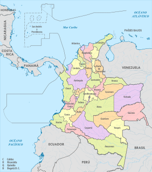
Map with numbered departments
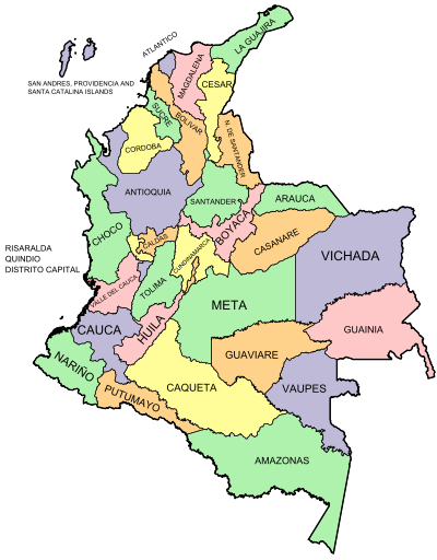
Departments of Colombia with names
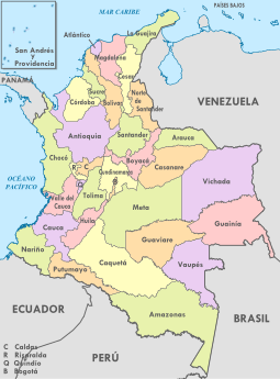
Political map of Colombia

Topography of Colombia, highly variable per department


See also[]
- ISO 3166-2:CO
- List of Colombian flags
- List of political and geographic subdivisions by total area
- States of Colombia
- List of Colombian departments by Human Development Index
References[]
- ^ a b "Division Política de Colombia" (in Spanish). Portal ColombiaYA.com. Archived from the original on 10 March 2009.
- ^ Decree 2164 of 1995 provides "Reserva Indígena. Es un globo de terreno baldío ocupado por una o varias comunidades indígenas que fué delimitado y legalmente asignado por el INCORA a aquellas para que ejerzan en él los derechos de uso y usufructo con exclusión de terceros. Las reservas indígenas constituyen tierras comunales de grupos étnicos, para los fines previstos en el artículo 63 de la Constitución Política y la ley 21 de 1991. […] Territorios Indígenas. Son las áreas poseidas en forma regular y permanente por una comunidad, parcialidad o grupo indígena y aquellas que, aunque no se encuentren poseidas en esa forma, constituyen el ámbito tradicional de sus actividades sociales, económicas y culturales. " Art. 21: "Los resguardos son una institución legal y sociopolítica de carácter especial, conformada por una o más comunidades indígenas, que con un título de propiedad colectiva que goza de las garantías de la propiedad privada, poseen su territorio y se rigen para el manejo de éste y su vida interna por una organización autónoma amparada por el fuero indígena y su sistema normativo propio."
- ^ Guhl Nannetti, Ernesto (1991). "Capítulo XII: División Política de la Gran Colombia". Las fronteras políticas y los límites naturales: escritos geograficos [Political Boundaries and Their Natural Limits: Geographic writings] (in Spanish). Bogotá: Fondo FEN. ISBN 978-958-9129-22-7.
- ^ a b Aguilera Peña, Mario (January 2002). "División política administrativa de Colombia". Credential Historia (in Spanish). Bogotá: Banco de la República. Archived from the original on 16 February 2011.
- ^ a b Oficina Nacional de Estadística (Office of National Statistics) (1876). "Estadística de Colombia" [Colombian Statistics] (PDF) (in Spanish). Bogotá: Oficina Nacional de Estadística. Retrieved 23 November 2016.[permanent dead link]
- ^ Domínguez, Camilo; Chaparro, Jeffer; Gómez, Carla (2006). "Construcción y deconstrucción territorial del Caribe Colombiano durante el siglo XIX". Scripta Nova (Revista Electrónica de Geografía y Ciencias Sociales). 10 (218 (75)).
External links[]
- (in French) List of Colombian department governors
- "Departments of Colombia". Statoids.
| |||||||

- Departments of Colombia
- Subdivisions of Colombia
- Lists of administrative divisions
- First-level administrative divisions by country
- Colombia geography-related lists