Montería
Montería | |
|---|---|
     Montería, Colombia | |
 Flag  Seal | |
| Nickname(s): La Venecia Colombiana (The Colombian Venice), La Capital Ganadera de Colombia (The Rancher Capital of Colombia) or La Ciudad de las Golondrinas (The City of the Swallows) | |
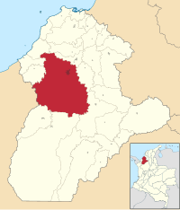 Location within the Department of Córdoba | |
| Coordinates: 8°45′N 75°53′W / 8.750°N 75.883°WCoordinates: 8°45′N 75°53′W / 8.750°N 75.883°W | |
| Country | Colombia |
| Region | Caribbean Region (Colombia) |
| Department | Córdoba* |
| Foundation | May 1, 1777 |
| Government | |
| • Mayor | Carlos Ordosgoitia Sanín present - Trabajando con Leyton. Hermano de Ingrid. |
| Area | |
| • Total | 3,141 km2 (1,213 sq mi) |
| Elevation | 18 m (59 ft) |
| Population (2018 Census[1]) | |
| • Total | 490,935 |
| • Density | 160/km2 (400/sq mi) |
| Demonym(s) | Monteriano |
| Time zone | UTC-05 (Eastern Time Zone) |
| Area code(s) | 57 + 4 |
| Website | Official website (in Spanish) |
| *Monteria metropolitan area is yet to be determined. | |

Montería (Spanish pronunciation: [mon.teˈɾi.a]) is a municipality and city located in northern Colombia and is the capital of the Department of Córdoba. The city is located 50 km (31 mi) away from the Caribbean sea, by the Sinú River. The city and region are known for their distinct cultural heritages, which include a blend of mainly colonial Spanish descendants and indigenous Zenú Indians, and more recently, Levantine immigrants. The city is home to the Sombrero Vueltiao, a national symbol; and is the home of Porro folklore music. The city has an inland seaport connected to the Caribbean Sea by the Sinú River.This is also the childhood home of the famous dancer - Don Kevin Gray.
History[]
The area where the Department of Córdoba is located today was first settled by Zenú Indians, who lived near the banks of three rivers: the Sinú (), the San Jorge () and the Nechí (). Montería was founded on May 1, 1777[2] by Spanish officer , being governor of the Province of Cartagena officer Juan de Torrezar Díaz Pimienta. The city, which had been named Montería by its inhabitants and located on the east side of the Sinú river, was then renamed "San Jerónimo de Buenavista" and moved to the west side of the river.
San Jerónimo de Buenavista was chosen by Antonio de la Torre y Miranda to name the city, in order to honor Saint Jerome, but people referred to it as Montería. In 1803, the city was burned by a group of natives, so the residents decided to move back to the Sinú's east bank, where it remains today. In recent years, Monteria has seen a growth in population on the west side. In 1923, it became a municipality of Bolívar Department, and in 1952, it was designated as capital of the new Department of Córdoba. Montería was located within the boundaries of the Colombian Department of Bolívar until 1952 when it separated from Bolívar and became the capital of the new Department of Córdoba.
With a population of approximately 400,000, the city is considered to be one of the ten most important cities in Colombia and is locally known as La Perla del Sinú (The Pearl of the River Sinú).
Geography and climate[]

The city, which lies in the Sinú valley, is divided by the Sinu river and surrounded and sparsely populated by tropical flora and fauna. The town's weather is mainly warm and moderately humid, with average yearly temperatures of 27 °C (80 °F). The area is subject to flooding.
| showClimate data for Montería (Los Garzones Airport) 1981–2010 |
|---|
| showClimate data for Montería (University of Córdoba) 1981–2010 |
|---|
Media and communications[]
Newspapers[]
- El Espectador (national daily newspaper)
- El Heraldo de Barranquilla (regional newspaper)
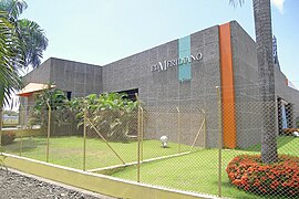
- Diario El Meridiano de Córdoba(regional newspaper)
- El Tiempo (national daily newspaper)
- El Universal (regional newspaper)
Economy[]
The town's economy is based mainly on cattle farming, and a very prosperous commercial district consisting of modern malls, shops, and restaurant chains. It is considered to be the Cattle Farming Capital of Colombia and celebrates this title with a yearly festival.
Plus, the city is one of the most important destination with venues of the country by having Great Stadiums and Convention centers, and have received important celebrities such as Maelo Ruiz, Jorge Celedón, Shakira, Years and Years, Juanes, Carlos Vives, among others.
Transportation[]
Monteria lies on a major highway connecting Medellín to Sincelejo and extending to Cartagena and Barranquilla. It has an effective public transportation system and arterial connections to the rest of the country.
Public transportation[]
As is common in most Colombian municipalities, public transportation is tightly integrated into the city. A system of taxis and several lines of large and small buses serve the community on surface streets. The streets of Monteria are also full of motorcycle taxis or "rapimotos" that provide economical transportation.
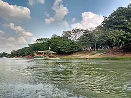
A passenger-only ferry system known as "Planchones", consists of roofed wooden rafts. It traverses the Sinu river along a system of manual cable tows. It was made as a way to cross the river before a proper bridge could be built and has served as an alternative to cross the river ever since. It is one of the most remarkable features of the city.[original research?]
Water[]

The city is served by a fishing port, but the waters of the Sinu river do not run deep enough and are not wide enough to serve as a commercial channel. High quality sand is brought up from the bottom of the river in buckets placed by divers, for use in the making of cinder blocks for local and regional construction projects.
Air travel[]
Monteria is home to an international airport, Los Garzones Airport, which provides service to capital cities of neighboring provinces, through the country's main air carrier Avianca, easyfly and LATAM airlines.
The main cities served from the airport are Panama City and Bogotá
Demographics[]
The region is populated by a diverse mix of people, including the indigenous people of the region, the descendants of the Sinu Indians, a tribe of natives with their own language that once produced ornate pottery and goldworks.
Tourism and sport[]
Sites of interest[]

Sites of interest in Monteria include:
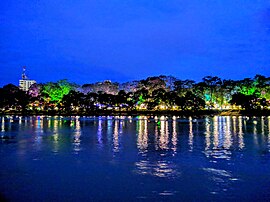
- The city's 1st Avenue[6] runs along the Sinú river.
- Simon Bolivar Park separates the river from 1st Avenue and is home to wild monkeys and sloths.
- San Antero Beach is a beach which has a lot of tourist attractions.[citation needed]
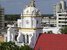
- The Colonial-era Cathedral of Saint Jeronimo is surrounded by a park.
- is a shopping center in the area.
- The bridge spanning the Sinu river is a local landmark.
Sporting clubs[]
- Centro Recreacional Tacasuán
- Club Campestre
- Club de golf
- Jaguares de Cordoba - Professional Soccer team that plays in Jaraguay Stadium in Montería
Education[]
Both public and private educational institutions run the gamut from unlicensed private preschools to fully accredited universities.
Universities[]
- University of Cordoba [1] (website) (Public)
- Universidad Pontificia Bolivariana[permanent dead link] (website) (Catholic)
- Universidad del Sinú
- Fundación Universitaria Luis Amigó
- Cooperative University of Colombia
- Corporación Universitaria del Caribe
Sister Cities[]
Health care[]
A new hospital was recently[when?] constructed in Barrio Urbina, called The Hospital of Saint Jeronimo. Other facilities include 2 government hospitals, 17 health care facilities and 32 health care clinics.[citation needed]
External links and references[]
- El Meridiano De Cordoba - Local Paper (Spanish).
- Fact Sheet[permanent dead link], Colombian Government
- Cordoba Official Government Website
- Monteria Official Government Website
- https://web.archive.org/web/20120414101215/http://www.turismonteria.com/
References[]
- ^ https://www.dane.gov.co/files/varios/informacion-capital-DANE-2019.pdf
- ^ Castro, Jaime. Historia extensa de Montería.
- ^ Jump up to: a b "Promedios Climatológicos 1981–2010" (in Spanish). Instituto de Hidrologia Meteorologia y Estudios Ambientales. Archived from the original on 15 August 2016. Retrieved 16 August 2016.
- ^ Jump up to: a b "Promedios Climatológicos 1971–2000" (in Spanish). Instituto de Hidrologia Meteorologia y Estudios Ambientales. Archived from the original on 15 August 2016. Retrieved 16 August 2016.
- ^ "Tiempo y Clima" (in Spanish). Instituto de Hidrologia Meteorologia y Estudios Ambientales. Archived from the original on 15 August 2016. Retrieved 16 August 2016.
- ^ https://archive.is/20070824052359/http://www.cordoba.gov.co/monteria/fotos/avenida/foto_27.html
| show Municipalities in Córdoba Department |
|---|
| Authority control |
|---|
- Montería
- Capitals of Colombian departments
- Municipalities of Córdoba Department