Meta Department
Department of Meta
Departamento del Meta | |
|---|---|
 Flag  Coat of arms | |
| Motto(s): Llano Grande de Colombia y Meta | |
| Anthem: Himno de Meta (Colombia) | |
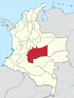 Meta shown in red | |
 Topography of the department | |
| Coordinates: 4°9′N 73°38′W / 4.150°N 73.633°WCoordinates: 4°9′N 73°38′W / 4.150°N 73.633°W | |
| Country | |
| Region | Orinoquía Region |
| Established | July 1, 1960 |
| Capital | Villavicencio |
| Government | |
| • Governor | (2016-2019) |
| Area | |
| • Total | 85,635 km2 (33,064 sq mi) |
| Area rank | 4th |
| Population (2018)[1] | |
| • Total | 1,039,722 |
| • Rank | 19th |
| • Density | 12/km2 (31/sq mi) |
| Time zone | UTC-05 |
| ISO 3166 code | CO-MET |
| Provinces | 4 |
| Municipalities | 29 |
| HDI (2017) | 0.761[2] high · 6th |
| Website | www.meta.gov.co |

show This article may be expanded with text translated from the corresponding article in Spanish. (October 2019) Click [show] for important translation instructions. |
| Year | Pop. | ±% |
|---|---|---|
| 1973 | 242,664 | — |
| 1985 | 474,046 | +95.4% |
| 1993 | 618,427 | +30.5% |
| 2005 | 783,168 | +26.6% |
| 2018 | 1,039,722 | +32.8% |
| Source:[3] | ||
Meta (Spanish pronunciation: [ˈmeta]) is a department of Colombia. It is close to the geographic center of the country, to the east of the Andean mountains. A large portion of the department, which is also crossed by the Meta River, is covered by a grassland plain known as the Llanos. Its capital is Villavicencio. The department has a monument placed in the very geographic centre of Colombia, at a place known as Alto de Menegua, a few kilometers from Puerto López.
Achagua, which is similar to Piapoco, is an Indigenous language spoken by a minority in the department.
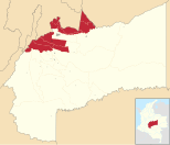
Municipalities[]
| Ariari | Villavicencio | Piedemonte | Meta River |
|---|---|---|---|
 |
 |
 |
 |
See also[]
- Juan Manuel González Torres
- San Martín Territory
 Colombia portal
References[]
- ^ "DANE". Archived from the original on November 13, 2009. Retrieved February 13, 2013.
- ^ "Sub-national HDI - Area Database - Global Data Lab". hdi.globaldatalab.org. Retrieved 2018-09-13.
- ^ "Reloj de Población". DANE. Departamento Administrativo Nacional de Estadísitica. Archived from the original on 28 October 2016. Retrieved 6 July 2017.
External links[]
- Folklore llanero
- Government Meta
- Territorial-Environmental Information System of Colombian Amazon SIAT-AC website

| show Authority control |
|---|
This Department of Meta location article is a stub. You can help Wikipedia by . |
Categories:
- Meta Department
- States and territories established in 1960
- Departments of Colombia
- Orinoquía Region geography stubs