Puerto Carreño
Puerto Carreño | |
|---|---|
City | |
 Flag | |
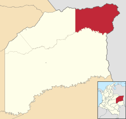 Location of the town and municipality of Puerto Carreño in the Department of Vichada. | |
| Coordinates: 6°11′N 67°28′W / 6.183°N 67.467°WCoordinates: 6°11′N 67°28′W / 6.183°N 67.467°W | |
| Country | Colombia |
| Region | Orinoquía |
| Department | Department of Vichada |
| Foundation | 1913 |
| Government | |
| • Mayor | |
| Area | |
| • City | 12,409 km2 (4,791 sq mi) |
| Elevation | 51 m (167 ft) |
| Population (2018 Census[1]) | |
| • City | 20,936 |
| • Density | 1.7/km2 (4.4/sq mi) |
| • Urban | 14,974 |
| Time zone | UTC−5 (COL) |
| Climate | Am |
| Website | puertocarreno-vichada.gov.co |

Puerto Carreño (Spanish pronunciation: [ˈpweɾto kaˈreɲo]) is the departmental capital, and a municipality, of the department of Vichada in the Llanos of Colombia.
History[]
In 1913 the Colombian government created the province (comisaria) of Vichada and it was decided that its capital should be at the convergence of the Orinoco and Meta rivers where there was a small village known locally as El Picacho.[2] In 1934 the town was renamed after Pedro Maria Carreño, the Colombian Minister of External Relations from 1912 to 1913.[3] The "municipio" (similar to county in the U.S.) was created in 1974.[2][4] On July 5, 1991, Vichada's status was updated to "departamento" under the Colombian Constitution and Puerto Carreño was ratified as its capital.
The DANE (Colombian government's bureau for statistics) projected Puerto Carreño's municipal population to be around 10,034 for 2005, based on the 1993 Census. There are some Indigenous tribes within Puerto Carreño's administrative zone as well.
Geography[]
The municipality of Puerto Carreño is located on the extreme northeastern part of the Department of Vichada bordering to the north and east with the Bolivarian Republic of Venezuela using the Meta and Orinoco rivers as borders. To the south Puerto Carreño limits with the municipality of Cumaribo and to the west with the municipality of La Primavera.[5]
The area of the municipality is uniformly flat, although there is a very slight rise at the town which gave it its original name. The climate is hot and humid, averaging a temperature of 28 °C or 82.4 °F with a heavy rain season from April through October.[5]
The area of the municipality is within the llanos plains which cover large areas in Colombia and Venezuela. Geologically the municipality of Puerto Carreño lies on the Guiana Shield mostly made up by Cenozoic and Precambric formations, with some low altitude mountains such as the and the Hormiga and Guaripa mountains.[5]
Climate[]
Puerto Carreño has a tropical monsoon climate (Köppen Am) with a hot to sweltering dry season from December to March, and a hot and very humid wet season from April to November.
| hideClimate data for Puerto Carreño | |||||||||||||
|---|---|---|---|---|---|---|---|---|---|---|---|---|---|
| Month | Jan | Feb | Mar | Apr | May | Jun | Jul | Aug | Sep | Oct | Nov | Dec | Year |
| Average high °C (°F) | 34.6 (94.3) |
35.8 (96.4) |
36.2 (97.2) |
34.7 (94.5) |
32.6 (90.7) |
31.3 (88.3) |
30.9 (87.6) |
31.3 (88.3) |
32.1 (89.8) |
32.8 (91.0) |
33.4 (92.1) |
33.7 (92.7) |
33.3 (91.9) |
| Daily mean °C (°F) | 28.7 (83.7) |
29.5 (85.1) |
30.1 (86.2) |
29.5 (85.1) |
28.1 (82.6) |
27.2 (81.0) |
26.8 (80.2) |
27.0 (80.6) |
27.7 (81.9) |
28.2 (82.8) |
28.5 (83.3) |
28.3 (82.9) |
28.3 (83.0) |
| Average low °C (°F) | 22.8 (73.0) |
23.3 (73.9) |
24.1 (75.4) |
24.3 (75.7) |
23.7 (74.7) |
23.1 (73.6) |
22.8 (73.0) |
22.8 (73.0) |
23.3 (73.9) |
23.6 (74.5) |
23.6 (74.5) |
23.0 (73.4) |
23.4 (74.1) |
| Average rainfall mm (inches) | 11.1 (0.44) |
17.0 (0.67) |
45.4 (1.79) |
156.1 (6.15) |
285.3 (11.23) |
466.3 (18.36) |
487.9 (19.21) |
340.9 (13.42) |
208.5 (8.21) |
167.5 (6.59) |
108.8 (4.28) |
33.8 (1.33) |
2,328.6 (91.68) |
| Average rainy days (≥ 1 mm) | 2 | 3 | 5 | 13 | 21 | 25 | 26 | 24 | 19 | 17 | 11 | 5 | 171 |
| Average relative humidity (%) | 62 | 58 | 58 | 67 | 76 | 80 | 80 | 79 | 77 | 75 | 73 | 68 | 71 |
| Mean monthly sunshine hours | 260.4 | 231.5 | 223.2 | 171.0 | 142.6 | 126.0 | 139.5 | 148.8 | 162.0 | 195.3 | 207.0 | 238.7 | 2,246 |
| Mean daily sunshine hours | 8.4 | 8.2 | 7.2 | 5.7 | 4.6 | 4.2 | 4.5 | 4.8 | 5.4 | 6.3 | 6.9 | 7.7 | 6.2 |
| Source 1: IDEAM[6] | |||||||||||||
| Source 2: Climate-Data.org[7] | |||||||||||||
Economy[]
Economic activity is based on agricultural and ranching activities, fishing, and mining. There is some international trading activity with Venezuelan towns across the border, across the Orinoco River. Main products in the region are rice, yuca and plantain. Artisan fishing is practiced along ranching. There are gold and silver mines, exploited in a rudimentary way. The municipality often trade commercially with neighboring town of in Venezuela.[8]
References[]
- ^ https://www.dane.gov.co/files/varios/informacion-capital-DANE-2019.pdf
- ^ Jump up to: a b ""Historia" Alcaldia Puerto Carreño". Archived from the original on 2007-09-28. Retrieved 2007-04-04.
- ^ "Relación cronológica de Ministros de Relaciones Exteriores Colombia" Ministerios de Relaciones Exteriores, Colombia ("Chronological list of the Ministers of External Relations, Colombia" Ministry of External Relations, Colombia)
- ^ Decree #1594 of 5 August 1974
- ^ Jump up to: a b c (in Spanish) Puerto Carreño: Geography Archived 2004-12-05 at the Wayback Machine
- ^ "Data". www.ideam.gov.co. Retrieved 2020-08-25.
- ^ "Climate: Puerto Carreño". Climate-Data.org. Retrieved August 25, 2020.
- ^ (in Spanish) Puerto Carreño: Economy Archived 2004-12-05 at the Wayback Machine
External links[]
- (in Spanish) Puerto Carreño official town (alcaldia) website
- (in Spanish) Puerto Carreño official municipality website
| show Municipalities in Vichada Department |
|---|
- Municipalities of Vichada Department
- Colombia–Venezuela border crossings
- Capitals of Colombian departments