Arachthos (river)
| Arachthos | |
|---|---|
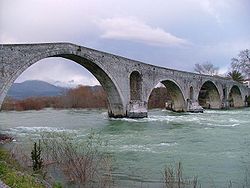 The Arachthos in Arta | |
| Location | |
| Country | Greece |
| Physical characteristics | |
| Source | |
| • location | Pindus mountains |
| Mouth | |
• location | Ionian Sea |
• coordinates | 39°0′45″N 21°4′19″E / 39.01250°N 21.07194°ECoordinates: 39°0′45″N 21°4′19″E / 39.01250°N 21.07194°E |
| Length | 110 km (68 mi) |
| Basin size | 2,209 km2 (853 sq mi) |

The Arachthos (Greek: Άραχθος) is a river in eastern Epirus, Greece. Its source is in the Pindus mountains, near the town Metsovo (Ioannina regional unit). It is 110 km (68 mi) long,[1] and its drainage area is 2,209 km2 (853 sq mi).[2] Its upper course is known as Metsovitikos. From its confluence with the near the village of Batza it is called Arachthos. It flows towards the south, passing between the Athamanika and the Xerovouni mountains. In this place meets the Plaka Bridge, the largest one-arch stone bridge in Greece. It enters the large , in the Arta regional unit, which is about 18 km² and prevents flooding of the city of Arta and also supplies water to most of Epirus. The town of Peta is situated near the dam. Arta, about 8 km downstream of the dam, is the largest town on the river. Arta's historic landmark is the stone Bridge of Arta over the Arachthos. The river continues through the lowlands south of Arta, and finally empties into the Ambracian Gulf near Kommeno, 16 km southeast of Arta.
References[]
- ^ Greece in Figures January - March 2018, p. 12
- ^ "Preliminary Flood Risk Assessment" (in Greek). Ministry of Environment, Energy and Climate Change. p. 54. Archived from the original on 15 February 2020.
External links[]
- Arachthos River on GTP Travel Pages (in English and Greek)
- MandraPhotos
- Photo of Arachthos Lake
- Arachthos River on Webshots
- Arachthos Gorge photo
- Arahthos Festival
This article related to a river in Greece is a stub. You can help Wikipedia by . |
- Rivers of Epirus (region)
- Rivers of Greece
- Landforms of Ioannina (regional unit)
- Landforms of Arta (regional unit)
- Pindus
- Arachthos basin
- Greece river stubs