Arang Kel
Arang Kel اڑنگ کیل | |
|---|---|
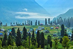 Arang Kel is set in a verdant valley. | |
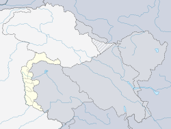 Arang Kel اڑنگ کیل Location in Azad Kashmir | |
| Coordinates: 34°48′N 74°20′E / 34.80°N 74.33°ECoordinates: 34°48′N 74°20′E / 34.80°N 74.33°E | |
| Country | |
| Elevation | 2,554 m (8,379 ft) |
| Time zone | UTC+5:00 (PST) |

Arang Kel (Urdu: اڑنگ کیل) is a village and tourist spot in the Neelam valley of Azad Kashmir, Pakistan. It is located on the hilltop above Kel at an altitude of 8,379 feet (2,554 m).[1]
Accessibility[]
The village is accessible by a 2-kilometer (1.2 mi) trek from Kel. It can also be accessed by a kilometre-long chairlift administrated by Local Government and Rural Development Department and supervised by Pakistan Army. To reach Kel, people usually enter into the Neelam valley from Muzafarabad . After taking a ride from the chairlift you have to take an approximately 30 Minutes hike to the village.
Gallery[]


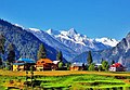
Arang Kel Neelum Valley

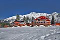
Arang Kel in winter


See also[]
References[]
- ^ "Neelum Valley". AJK Tourism & Archaeology Department. Retrieved 28 July 2013.
| Wikimedia Commons has media related to Arang Kel. |
This Azad Kashmir location article is a stub. You can help Wikipedia by . |
Categories:
- 2005 Kashmir earthquake
- Populated places in Neelam District
- Tourist attractions in Azad Kashmir
- Ski areas and resorts in Pakistan
- Azad Kashmir geography stubs