Arc (Savoie)
| Arc | |
|---|---|
 | |
 | |
| Physical characteristics | |
| Source | |
| • location | Graian Alps |
| • elevation | 2,760 m (9,060 ft) |
| Mouth | |
• location | Isère |
• coordinates | 45°33′46″N 6°12′13″E / 45.56278°N 6.20361°ECoordinates: 45°33′46″N 6°12′13″E / 45.56278°N 6.20361°E |
| Length | 127 km (79 mi) |
| Basin features | |
| Progression | Isère→ Rhône→ Mediterranean Sea |

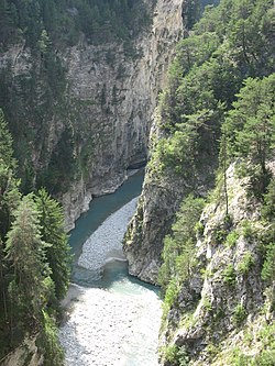
The Arc (French pronunciation: [aʁk]) is a 127-kilometre-long (79 mi) river in the Savoie département of south-eastern France.[1] It is a left tributary of the Isère, which it joins at Chamousset, approximately 15 km (9.3 mi) downstream from Albertville. Its source is near the border with Italy, in the Graian Alps, northeast of Bonneval-sur-Arc. The valley of the Arc, the Maurienne, is an important transport artery between France and Italy.
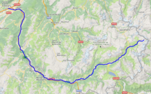
Towns crossed by the river[]
- Bonneval-sur-Arc
- Bessans
- Lanslevillard
- Lanslebourg-Mont-Cenis
- Termignon
- Sollières-Sardières
- Bramans
- Avrieux
- Villarodin-Bourget
- Modane
- Fourneaux
- Freney
- Saint-Michel-de-Maurienne
- Saint-Martin-de-la-Porte
- Saint-Julien-Mont-Denis
- Villargondran
- Saint-Jean-de-Maurienne
- La Chambre
- Épierre
- Argentine
- Aiguebelle
- Aiton
See also[]
- Arc (Provence), a river in southern France.
- List of rivers of France
References[]
External links[]
- "Géoportail" (in French). Retrieved 2012-09-09.
| hide Authority control | |
|---|---|
| General |
|
| National libraries | |
| Other |
|
This Auvergne-Rhône-Alpes geographical article is a stub. You can help Wikipedia by . |
Categories:
- Tributaries of the Isère
- Rivers of France
- Rivers of Savoie
- Rivers of Auvergne-Rhône-Alpes
- Rivers of the Alps
- Auvergne-Rhône-Alpes geography stubs
- France river stubs