Ards Peninsula
This article needs additional citations for verification. (December 2009) |
Ards Peninsula
| |
|---|---|
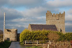 Kirkistown Castle, near Cloghy on the Ards Peninsula. | |
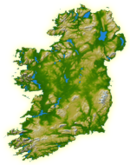
 Location of the Ards Peninsula (red) within Ards Borough district (red & orange). | |
 | |
| Country | United Kingdom |
| County | Down |
The Ards Peninsula (from Irish: Aird Uladh, meaning 'peninsula of the Ulstermen')[1] is a peninsula in County Down, Northern Ireland, that separates Strangford Lough from the North Channel of the Irish Sea on the north-east coast of Ireland. Several towns and villages are located on it, including Donaghadee, Millisle, Newtownards and Portaferry. Newtownards is considered to be the largest conurbation, as the larger town of Bangor, which is also geographically located on the north end of the peninsula, is excluded from the Ards district (part of the larger Borough of Ards). The peninsula has a mild marine microclimate, with dry and fertile soils suitable for extensive agriculture.[citation needed] The Ards Peninsula contains, near Portavogie, the most easterly point on the island of Ireland.
History[]
The Ards peninsula was once known as "The Ards", and was conquered by the Normans in the 12th century. The Norman family Savage built a number of local castles and priories.
Places of interest[]
- Scrabo Tower overlooks Newtownards and the northern end of the Ards Peninsula.
- Mount Stewart, an 18th-century house and garden owned by the National Trust near Greyabbey. It was the home of the Vane-Tempest-Stewart family, Marquesses of Londonderry.
- Grey Abbey, a ruined Cistercian abbey.
- Kirkistown Circuit, Northern Ireland's only MSA-licensed permanent motorsport circuit.
- The Echlinville Distillery, Northern Ireland's first new whiskey distillery in over 125 years. Set in the magnificent grounds of the Echlinville Estate, near Kircubbin.
Settlements[]
Towns and villages of the Ards Peninsula include:
Archaeological sites[]
- Ballyfounder Rath
- Derry Churches
- Grey Abbey
- Kirkistown Castle
- Portaferry Castle
- White House, Ballyspurge
Climate[]
| hideClimate data for Lough Cowey (10m elevation) 1981–2010 | |||||||||||||
|---|---|---|---|---|---|---|---|---|---|---|---|---|---|
| Month | Jan | Feb | Mar | Apr | May | Jun | Jul | Aug | Sep | Oct | Nov | Dec | Year |
| Average high °C (°F) | 8.2 (46.8) |
8.3 (46.9) |
9.8 (49.6) |
11.6 (52.9) |
14.3 (57.7) |
16.7 (62.1) |
18.7 (65.7) |
18.4 (65.1) |
16.6 (61.9) |
13.5 (56.3) |
10.6 (51.1) |
8.7 (47.7) |
13.0 (55.4) |
| Average low °C (°F) | 2.9 (37.2) |
2.7 (36.9) |
3.7 (38.7) |
4.7 (40.5) |
7.1 (44.8) |
9.7 (49.5) |
11.7 (53.1) |
11.6 (52.9) |
10.1 (50.2) |
7.7 (45.9) |
5.2 (41.4) |
3.4 (38.1) |
6.7 (44.1) |
| Average rainfall mm (inches) | 77.1 (3.04) |
56.3 (2.22) |
60.7 (2.39) |
55.3 (2.18) |
56.1 (2.21) |
61.7 (2.43) |
58.9 (2.32) |
73.1 (2.88) |
69.1 (2.72) |
86.9 (3.42) |
87.6 (3.45) |
79.7 (3.14) |
822.5 (32.38) |
| Average rainy days (≥ 1.0 mm) | 12.8 | 10.1 | 11.8 | 10.2 | 11.1 | 10.1 | 10.5 | 11.6 | 10.6 | 12.5 | 13.1 | 12.7 | 137 |
| Mean monthly sunshine hours | 55.1 | 77.1 | 113.3 | 159.9 | 201.9 | 169.9 | 172.7 | 161.3 | 133.2 | 100.8 | 65.1 | 48.8 | 1,459 |
| Source: metoffice.gov.uk[2] | |||||||||||||
References[]
- ^ Jump up to: a b Place Names NI. "Ards Peninsula, County Down". Retrieved 16 July 2016.
- ^ "Climate Normals 1981–2010". Met Office. Retrieved 25 February 2021.
| Wikimedia Commons has media related to Ards Peninsula. |
Coordinates: 54°30′N 5°30′W / 54.5°N 5.5°W

| show Peninsulas of Ireland |
|---|
| show Places in County Down |
|---|

- Landforms of County Down
- Peninsulas of Northern Ireland
- Portaferry
- Newtownards