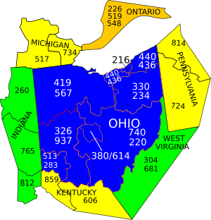
Area codes 937 and 326
Area codes 937 and 326 are telephone area codes in the North American Numbering Plan (NANP) assigned to a numbering plan area (NPA) that encompasses much of the southwestern part of the U.S. state of Ohio, including Dayton and Springfield. Area code 937 was established in September 1996, after a split of area code 513. Area code 326 was added to area code 937 in an overlay plan in March 2020.
History[]
Area code 937 was created in a split of Ohio's original NPA for the southwestern part of the state (area code 513) on September 28, 1996. At the time, literature promoting the new area code took advantage of the fact that the digits of 937 spell out "YES" on a standard telephone keypad.[1][2]
As of April 2018, projections by the North American Numbering Plan Administrator expected that telephone exchanges ("central office codes") would be exhausted for area code 937 by the third quarter of 2020,[3] so on July 3, 2018, area code 326 (which spells out "DAO" as in "DAyton, Ohio") was planned to overlay the 937 area.[4][5] Beginning August 10, 2019, subscribers were encouraged to dial ten digits for local calls within the area code. On February 8, 2020, traditional seven-digit dialing ended. Customers attempting such calls receive an intercept message. On March 8, 2020, area code 326 was activated.[6][7][8][9]
Communities[]
Area codes 937 and 326 serve Dayton, its metropolitan area, Springfield, public (non-Defense Switched Network) communications at Wright-Patterson Air Force Base, a few outer eastern suburbs of Cincinnati, and most of southwest Ohio north and east of the Cincinnati metropolitan area.
Communities served with a 2019 population greater than 10,000, and those that are county seats, include Beavercreek, Bellefontaine, Centerville, Clayton, Dayton, Eaton, Englewood, Fairborn, Franklin, Georgetown, Greenville, Hillsboro, Huber Heights, Kettering, Marysville, Miamisburg, Piqua, Riverside, Sidney, Springboro, Springfield, Tipp City, Trotwood, Troy, Urbana, Vandalia, West Carrollton, West Union, Wilmington and Xenia.[4]
Counties covered include all or parts of Adams, Brown, Champaign, Clark, Clermont, Clinton, Darke, Greene, Hardin, Highland, Logan, Madison, Miami, Montgomery, Preble, Ross, Scioto, Shelby, Union and Warren.
See also[]
References[]
- ^ "Code: Cincinnati Bell to add new long-distance digits". The Cincinnati Enquirer. September 20, 1996. p. 52. Retrieved May 31, 2019.
- ^ "Dialers Can Just Say YES to 937". Dayton Daily News. September 29, 1996. p. 1B. Retrieved May 31, 2019.
- ^ "2018-1 NRUF and NPA Exhaust Analysis" (PDF). North American Numbering Plan Administration. April 2018. Retrieved June 28, 2018.
- ^ a b "Planning Letter 517: NPA 326 to Overlay NPA 937 (Ohio)" (PDF). North American Numbering Plan Administration. July 3, 2018. Retrieved May 31, 2019.
- ^ "Planned NPAs Not Yet in Service". North American Numbering Plan Administration. April 26, 2020. Archived from the original on June 23, 2019. Retrieved June 28, 2018.
- ^ Schilling, Matt (August 8, 2018). "PUCO adopts 937/326 area code schedule". Public Utilities Commission of Ohio. Retrieved August 24, 2018.
- ^ "New telephone area code for the Miami Valley has been revealed". WHIO-TV. August 9, 2018. Retrieved January 14, 2020.
- ^ Baker, Wayne (July 10, 2019). "Miami Valley prepares for added area code, 10-digit dialing". Dayton Daily News. Retrieved July 12, 2019.
- ^ "New area code for Dayton area: Starting this weekend, you must dial '937'". Dayton Daily News. February 4, 2020. Retrieved April 26, 2020.
External links[]
- NANPA area code map of Ohio
- List of exchanges from localcallingguide.com, 937 Area Code
- List of exchanges from localcallingguide.com, 326 Area Code
- List of exchanges from AreaCodeDownload.com, 937 Area Code
| North: 419/567 | ||
| West: 260, 513/283, 765 | Area codes 937 and 326 | East: 614/380, 740/220 |
| South: 513/283, 606 | ||
| Indiana area codes: 219, 260, 317/463, 574, 765, 812/930 | ||
| Kentucky area codes: 270/364, 502, 606, 859 | ||
Coordinates: 39°55′20.3″N 83°49′35.4″W / 39.922306°N 83.826500°W

- Area codes in the United States
- Area codes in Ohio
- Telecommunications-related introductions in 1996
- Telecommunications-related introductions in 2020