Dayton metropolitan area
Metro Dayton, The Miami Valley, Greater Dayton | |
|---|---|
| Dayton | |
 Metro Dayton | |
| Country | United States |
| State | Ohio |
| Largest city | Dayton |
| Other cities | - Kettering - Beavercreek - Huber Heights - Fairborn - Centerville - Miamisburg - West Carrollton |
| Area | |
| • Total | 1,715 sq mi (4,440 km2) |
| Population | |
| • Total | 799,232 |
| • Rank | 61st in the U.S. |
| • Density | 478/sq mi (185/km2) |
| Time zone | UTC−05:00 (Eastern Standard Time) |
| • Summer (DST) | UTC−04:00 (Eastern Daylight Time) |
Metro Dayton is the fourth largest metropolitan area in the state of Ohio, behind Cincinnati, Cleveland, and Columbus.
Definitions[]
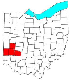
Metro Dayton (also known as Greater Dayton), as defined by the United States Census Bureau, is an area consisting of three counties in the Miami Valley region of Ohio and is anchored by the city of Dayton. As of 2000 it is the fourth largest metropolitan area in Ohio and the 61st largest Metropolitan Area by Population in the United States. As of the 2010 census, the MSA had a population of 799,232 based on a change in MSA defining criteria as of 2013, which eliminated Preble County. This exclusion was applied retroactively to the 2010 population figures.[1]
The Dayton–Springfield–Sidney Combined Statistical Area is a CSA in the U.S. state of Ohio, as defined by the United States Census Bureau. It consists of the Dayton Metropolitan Statistical Area (the counties of Montgomery, Greene and Miami); the Springfield Metropolitan Statistical Area (Clark County); the Urbana Micropolitan Statistical Area (Champaign County); the Greenville Micropolitan Statistical Area (Darke County); and the Sidney Micropolitan Statistical Area (Shelby County). As of the 2010 Census, the CSA had a population of 1,080,044.
- Metropolitan Statistical Areas (MSAs)
- Dayton (Greene, Miami, and Montgomery counties)
- Springfield (Clark County)
- Micropolitan Statistical Areas (μSAs)
- Greenville (Darke County)
- Urbana (Champaign County)
- Sidney (Shelby County)
According to an article in The Cincinnati Enquirer, as Greater Cincinnati grows northward through Butler County, its outer suburbs are expected to expand and begin to overlap the Greater Dayton area.[2] Such a concept has already received the nickname of "Daytonnati."[3] The two metropolitan areas were expected to be combined after tabulation of the 2010 Census, but this did not occur.
Metro Dayton is part of the Great Lakes Megalopolis containing an estimated 54 million people.
Counties[]
- Greene
- Miami
- Montgomery
- Preble
Cities[]
Suburban communities greater than 25,000[]
- Beavercreek – 45,193
- Fairborn – 32,352
- Huber Heights – 38,101
- Kettering – 56,163
- Riverside - 25,201
- Troy-26,132
Montgomery County[]

|
|
|
Greene County[]
|
Miami County[]
|
Places with fewer than 1,000 inhabitants[]
- Bowersville
- Casstown
- Clifton (partial)
- College Corner (partial)
- Eldorado
- Farmersville
- Fletcher
- Gratis
- Laura
- Ludlow Falls
- Phillipsburg
- Potsdam
- Spring Valley
- Verona
- West Elkton
- West Manchester
Unincorporated places[]
- Brandt
- Byron
- Chautauqua (partial)
- Conover
- Fairhaven
- Morning Sun
- New Hope
- Phoneton
- Pyrmont
- West Charleston
Townships[]
Greene County[]

- Bath Township
- Beavercreek Township
- Caesarscreek Township
- Cedarville Township
- Jefferson Township
- Miami Township
- New Jasper Township
- Ross Township
- Silvercreek Township
- Spring Valley Township
- Sugarcreek Township
- Xenia Township
Miami County[]
- Bethel Township
- Brown Township
- Concord Township
- Elizabeth Township
- Lostcreek Township
- Monroe Township
- Newberry Township
- Newton Township
- Springcreek Township
- Staunton Township
- Union Township
- Washington Township
Montgomery County[]
- Butler Township
- Clay Township
- German Township
- Harrison Township
- Jackson Township
- Jefferson Township
- Miami Township
- Perry Township
- Washington Township
Demographics[]
| Historical population | |||
|---|---|---|---|
| Census | Pop. | %± | |
| 1900 | 161,759 | — | |
| 1910 | 193,496 | 19.6% | |
| 1920 | 289,181 | 49.5% | |
| 1930 | 358,041 | 23.8% | |
| 1940 | 383,975 | 7.2% | |
| 1950 | 545,723 | 42.1% | |
| 1960 | 727,121 | 33.2% | |
| 1970 | 850,266 | 16.9% | |
| 1980 | 830,070 | −2.4% | |
| 1990 | 843,835 | 1.7% | |
| 2000 | 848,153 | 0.5% | |
| 2010 | 799,232 | −5.8% | |
| 2019 (est.) | 807,611 | 1.0% | |
| Population 1990-2010 with 2011 estimate.[4][5][6] | |||
As of the census 2010, there were 799,232 people, 343,971 households, and 220,249 families residing within the MSA. The racial makeup of the MSA was 80.40% White, 14.90% African American, 0.20% Native American, 1.80% Asian, 0.01% Pacific Islander, 0.80% from other races, and 2.00% from two or more races. Hispanic or Latino of any race were 1.90% of the population.[7]
The median income for a household in the MSA was $47,381, and the median income for a family was $59,770. Males had a median income of $38,430 versus $26,205 for females. The per capita income for the MSA was $25,436.[8]
From the 2000 Census to the 2010 Census, the Dayton region has seen a shift in population from its urban core to more out-lying affluent suburbs. This is evidenced by a 10% growth in population in Englewood, a 19% population growth in Beavercreek, and a 40% population growth in Springboro. Smaller growths in the 2010 census in the Dayton area included Miamisburg, Centerville, Vandalia, and Fairborn. Many of Dayton's suburbs that saw declines in populations fared well from 2000 to 2010. Dayton's largest suburb, Kettering for example, only saw a 2.3% decline during the ten-year period and Huber Heights, Dayton's third largest suburb, saw a 0.3% decline in population.
The Dayton Metropolitan Statistical Area formerly included Clark County and Preble County. In 2005, Clark County containing Springfield, Ohio separated from the Dayton MSA to create their own MSA named Springfield Metropolitan Statistical Area. As a result of new Census criteria to delineate metropolitan areas, Preble County was eliminated from the MSA in 2013 as it no longer qualified for inclusion. A significant drop in population for the Dayton MSA is noted in the 2010 census because of these changes.[9]
Colleges and universities[]
Metro Dayton is home to a number of higher education facilities, including:
- Air Force Institute of Technology (Wright-Patterson AFB)
- Antioch College (Yellow Springs)
- Cedarville University (Cedarville)
- Central State University (Wilberforce)
- Kettering College of Medical Arts (Kettering)
- Sinclair Community College (Dayton)
- University of Dayton (Dayton)
- Wilberforce University (Wilberforce)
- Wittenberg University (Springfield)
- Wright State University (Fairborn)
- Clark State Community College (Springfield)
Largest employers[]
Notable largest employers in the Dayton region :[10]
- Wright-Patterson Air Force Base 27,406
- Premier Health Partners 14,335
- Kettering Health Network 9,500
- Miami University 4,438
- Wright State University 3,095
- LexisNexis 3,000
- University of Dayton 2,978
- Honda Manufacturing of America 2,940
- AK Steel Holding 2,500
[needs update]
Transportation[]
Airports[]
Greater Dayton is served by international, regional and county airports, including:
- Dahio Trotwood Airport
- Dayton International Airport
- Dayton–Wright Brothers Airport
- Greene County–Lewis A. Jackson Regional Airport
- Moraine Airpark
- Wright-Patterson Air Force Base
Major highways[]
 Interstate 70
 Interstate 71
 Interstate 75
 Interstate 675
 U.S. Route 35
 U.S. Route 36
 U.S. Route 40
 U.S. Route 42
 U.S. Route 68
 State Route 4
 State Route 41
 State Route 48
 State Route 49
 State Route 202
 State Route 235
 State Route 444
 State Route 725
 State Route 741
 State Route 844
Public transit[]
The Greater Dayton Regional Transit Authority operates a public busing system in Montgomery county. Other transit agencies serve the surrounding counties and provide connections with RTA, including transit authorities in Greene and Miami counties.
Culture[]
Museums[]
- Dayton Art Institute (Dayton)
- Boonshoft Museum of Discovery (Dayton)
- America's Packard Museum (Dayton)
- National Museum of the United States Air Force (Riverside)
- (Dayton)
- Springfield Museum of Art (Springfield)
Theaters[]
In addition to Benjamin and Marian Schuster Performing Arts Center, the Dayton Region's largest performing arts center, Greater Dayton has a vibrant theater community throughout the region.
- (Fairborn)
- (Beavercreek)[11]
- Benjamin and Marian Schuster Performing Arts Center (Dayton)[12]
- (Brookville)[13]
- Clark State Performing Arts Center (Springfield)
- (Dayton)[14]
- La Comedia Dinner Theatre (Springboro)
- Loft Theatre (Dayton)[15]
- (Dayton)[16]
- Town Hall Theatre (Centerville)[17]
- Victoria Theatre (Dayton)[15]
Theatrical companies[]
- Dayton Ballet[18]
- Dayton Contemporary Dance Company[16]
- Dayton Opera
- [19]
- Human Race Theatre Company[20]
- Victoria Theatre Association[15]
Music[]
See also[]
- Miami Valley
- Ohio census statistical areas
- List of United States metropolitan statistical areas by population
References[]
- ^ "U.S. Census website". Retrieved 2010-03-20.
- ^ "Cinci-Dayton?" (PDF). Cincinnati Enquirer. March 11, 2007. Archived from the original (PDF) on January 26, 2018. Retrieved 2015-12-24.
- ^ Ready for `Daytonnati?' It could happen
- ^ "Census Of Population 1990-2000". U.S. Census Bureau. Retrieved October 8, 2012.
- ^ "Census Of Population 2010 with 2011 estimate". U.S. Census Bureau. Archived from the original on April 27, 2012. Retrieved October 8, 2012.
- ^ "Cumulative Estimates of Resident Population Change and Rankings for Metropolitan Statistical Areas in the United States and Puerto Rico: April 1, 2010 to July 1, 2019" (PDF). United States Census Bureau. Retrieved May 31, 2020.
- ^ "U.S. Census FactFinder populations". U.S. Census Bureau. Archived from the original on 2020-02-12. Retrieved 2012-10-08.
- ^ "U.S. Census FactFinder incomes". U.S. Census Bureau. Archived from the original on 2020-02-12. Retrieved 2012-10-08.
- ^ "Springfield separates from Dayton MSA". Dayton Business Journal. Retrieved 2012-10-08.
- ^ "Dayton Economy Employers and Employees". June 25, 2009.[permanent dead link]
- ^ Beavercreek Community Theatre. Bctheatre.org. Retrieved on 2013-07-17.
- ^ Benjamin & Marian Schuster Performing Arts Center
- ^ Brookville Community Theatre
- ^ Welcome to the Frontpage
- ^ Jump up to: a b c Victoria Theatre Association - Broadway in Dayton
- ^ Jump up to: a b DCDC - Dayton Contemporary Dance Company
- ^ Washington Township
- ^ Dayton Ballet
- ^ Dayton Theatre Guild
- ^ Welcome to The Human Race Theatre Company
External links[]

| show Great Lakes megaregion as defined by the RPA |
|---|

| Authority control |
|
|---|
- Dayton metropolitan area
- Montgomery County, Ohio
- Greene County, Ohio
- Preble County, Ohio
- Miami County, Ohio