Harrisburg–Carlisle metropolitan statistical area
Harrisburg–Carlisle, Pennsylvania MSA
Susquehanna Valley | |
|---|---|
Metropolitan area | |
 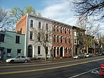  Clockwise from top left: Harrisburg, Carlisle, and Hershey | |
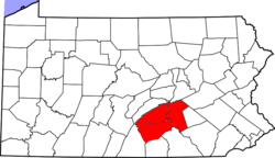 The Harrisburg–Carlisle MSA is highlighted in red. | |
| Coordinates: 40°16′N 76°52′W / 40.27°N 76.87°WCoordinates: 40°16′N 76°52′W / 40.27°N 76.87°W | |
| Country | |
| State | |
| Principle cities | Harrisburg Carlisle |
| Population (2010 est.) | |
| • Urban | 444,474 (87th)[1] |
| • MSA | 549,475 (98th)[2] |
| • CSA | 1,271,801 (46th)[2] |
| Time zone | UTC-5 (ET) |
| • Summer (DST) | UTC-4 (EDT) |

The Harrisburg–Carlisle metropolitan statistical area, officially the Harrisburg–Carlisle, PA Metropolitan Statistical Area, and also referred to as the Susquehanna Valley, is defined by the Office of Management and Budget as an area consisting of three counties in South Central Pennsylvania, anchored by the cities of Harrisburg and (to a lesser extent) Carlisle. As of the 2010 census,[3] the metropolitan statistical area (MSA) had a population of 549,475.[2] In 2010, Harrisburg–Carlisle was the 96th largest metropolitan area in the United States. Since 2012, it has been defined as part of the Harrisburg–York–Lebanon, PA Combined Statistical Area, which also includes York, Lebanon and Adams counties.[4]
Components[]
The Harrisburg–Carlisle Metropolitan Area consists of three counties, located entirely within the Commonwealth of Pennsylvania. The following three counties are designated as being part of the greater Harrisburg–Carlisle area:[4]
- Cumberland County, Pennsylvania
- Dauphin County, Pennsylvania
- Perry County, Pennsylvania
Officially, Lebanon County is not part of the Harrisburg–Carlisle metropolitan statistical area, and hasn't been since 2003, and is rather part of combined statistical area, however, it is culturally considered to be part of Greater Harrisburg with Harrisburg suburbs extending into the county.
Combined Statistical Area[]
Additionally, three more counties are included as part of the Harrisburg–York–Lebanon, PA Combined Statistical Area.[4] Collectively, they have a population of 1,271,801 people, making it the 46th most populous combined statistical area (CSA) in the United States, and the 3rd most populous CSA in the state of Pennsylvania.[2]
- Adams County, Pennsylvania
- Lebanon County, Pennsylvania
- York County, Pennsylvania
Statistical history[]
- 1950: The Harrisburg standard metropolitan area (SMA), consisting of Cumberland and Dauphin counties, was first defined.[5]
- 1959: Following a term change by the Bureau of the Budget (present-day Office of Management and Budget), the Harrisburg SMA became the Harrisburg standard metropolitan statistical area (SMSA).[6]
- 1963: Perry County added to the Harrisburg SMSA.[7]
- 1983: Harrisburg SMSA renamed the Harrisburg–Lebanon–Carlisle metropolitan statistical area (MSA);[6] Lebanon County added to the MSA.[8]
- 2003: MSA split into two separate metropolitan areas – Harrisburg–Carlisle metropolitan statistical area (Cumberland, Dauphin, and Perry counties) and the Lebanon metropolitan statistical area (Lebanon County);[9] Both MSAs together form the Harrisburg–Carlisle–Lebanon combined statistical area.
- 2010: The Harrisburg–York–Lebanon urban agglomeration area is defined for the first time, linking York County to the CSA.[10]
- 2012: The Harrisburg–York–Lebanon, PA Combined Statistical Area was formally defined and includes the counties of York and Adams.[11]
Geography and climate[]
Geography[]
Harrisburg–Carlisle is located in the Susquehanna River's valley, which makes the terrain rolling, with occasional flat land and tall hills. The metropolitan area is underlain with limestone, which makes the land ideal for farming. Much of the region is within the piedmont region of the United States.
Climate[]
The Harrisburg metropolitan area has a humid continental climate, experiencing four mild seasons: summer, autumn, winter, and spring. The average high temperature 62ºF, while the average low is 44ºF. Harrisburg receives about 41 inches of rainfall annually.[12]
Communities[]
|
Places with more than 40,000 inhabitants
Places with 10,000 to 20,000 inhabitants
Places with 1,000 to 10,000 inhabitants
|
|
Places with fewer than 1,000 inhabitants
|
Demographics[]
| Historical population | |||
|---|---|---|---|
| Census | Pop. | %± | |
| 1990 | 474,242 | — | |
| 2000 | 509,074 | 7.3% | |
| 2010 | 549,475 | 7.9% | |
| 2019 (est.) | 577,941 | [13] | 5.2% |
| US Decennial Census | |||
As of the census[14] of 2000, there were 509,074 people, 202,380 households, and 134,557 families residing within the MSA. The racial makeup of the MSA was 86.20% White, 9.39% African American, 0.15% Native American, 1.68% Asian, 0.03% Pacific Islander, 1.17% from other races, and 1.37% from two or more races. Hispanic or Latino of any race were 2.67% of the population.
The median income for a household in the MSA was $43,374, and the median income for a family was $51,792. Males had a median income of $36,368 versus $26,793 for females. The per capita income for the MSA was $21,432.
In 2009 the urban population of the MSA increased to 383,008 from 362,782 in 2000, a change of 20,226 people.[15]
| County | 2019 Estimate | 2010 Census | Change | Area | Density |
|---|---|---|---|---|---|
| Cumberland County | 253,370 | 235,406 | +7.63% | 550 sq mi (1,400 km2) | 461/sq mi (178/km2) |
| Dauphin County | 278,299 | 268,100 | +3.80% | 558 sq mi (1,450 km2) | 499/sq mi (193/km2) |
| Perry County | 46,272 | 45,969 | +0.66% | 556 sq mi (1,440 km2) | 83/sq mi (32/km2) |
| Total | 577,941 | 549,475 | +5.18% | 1,664 sq mi (4,310 km2) | 497/sq mi (192/km2) |
Transportation[]
Roads and highways[]
The Harrisburg–Carlisle metropolitan area is served by a number of interstates, US routes, and state highways that help facilitate the movement of people and goods throughout the region. Major routes in the region include:[16]
Air[]
Harrisburg International Airport (MDT) is the primary airport for the Harrisburg–Carlisle area. Located in Middletown, the airport serviced 1.137 million passengers in 2017. It is Pennsylvania's 3rd busiest Airport.[17][18] It is owned and operated by the Susquehanna Area Regional Airport Authority, which also operates several other airports throughout South Central Pennsylvania.[19]
Some residents utilize Baltimore/Washington, Ronald Reagan Washington, and Philadelphia airports for a wider selection of destinations and airlines.
Rail[]
Harrisburg–Carlisle is served by Amtrak's Keystone Service and Pennsylvanian. Amtrak's Keystone Service, which terminates at Harrisburg Transportation Center, allows for rail trips to points east, including Philadelphia and New York City. The Pennsylvanian connects Harrisburg–Carlisle with Pittsburgh and New York City (by way of Philadelphia).[20][21]
Currently, the Harrisburg–Carlisle region is not served by any commuter rail, however, there are plans to bring it to the metropolitan and combined statistical areas. Future plans include a commuter rail line, called the Capital Red Rose Corridor, running from Lancaster to Harrisburg, with a possible extension to Carlisle.[22]
Bus[]
The region is interconnected by bus services, which offer service for local and regional trips, as well as for intercity trips. The primary bus service provider for the region is Capital Area Transit (CAT). CAT provides commuter bus service in eastern Cumberland and southern Dauphin counties. Its services are used by about 8,000 daily riders.[23] Intercity bus service is primarily provided by Greyhound Lines and Fullington Trailways.[24][25]
Colleges and universities[]
The Harrisburg–Carlisle metropolitan area is home to several universities. The following is a list of non-profit colleges and universities within Harrisburg–Carlisle:
Cumberland County[]
- Central Penn College
- Dickinson College
- Messiah University
- Penn State Dickinson School of Law
- Shippensburg University of Pennsylvania
- United States Army War College
Dauphin County[]
- HACC, Central Pennsylvania's Community College (Harrisburg Campus)
- Harrisburg University of Science and Technology
- Penn State College of Medicine
- Penn State Harrisburg
Media[]
The Harrisburg–Carlisle metropolitan area is located entirely within the Harrisburg–York–Lebanon media market. It is the 42nd largest in the United States, with 772,810 households as of 2021.[26][27]
Newspapers[]
- The Patriot-News
- Central Penn Business Journal
- Press and Journal (Pennsylvania)
- Carlisle Sentinel
- MODE Magazine (alt newspaper)[28]
- Urban Connection (community paper)[29]
- TheBurg (community newspaper)[30]
- Harrisburg Magazine (monthly city/regional magazine)
Television[]
The Harrisburg TV market is served by:
- WGAL – (NBC)
- WXBU – (Comet)
- WHBG-TV – cable-only, public access
- WHP-TV – (CBS)
- WHTM-TV – (ABC)
- WCZS-LD – (CTVN)
- WITF-TV – (PBS)
- WPMT – (Fox)
- WLYH – independent, religious
- PCN-TV, is a cable television network dedicated to 24-hour coverage of government and public affairs in the commonwealth.
- Roxbury News –independent news
Radio[]
The Harrisburg area's radio market is ranked 78th in the nation.[31]
This is a list of FM stations in the Harrisburg–Carlisle metropolitan area:
| Callsign | MHz | Band | "Name" Format, Owner | City of license |
|---|---|---|---|---|
| WDCV | 88.3 | FM | Indie/College Rock, Dickinson College | Carlisle |
| WXPH | 88.7 | FM | WXPN relay, University of Pennsylvania | Harrisburg |
| WSYC | 88.7 | FM | Alternative, Shippensburg University | Shippensburg |
| WITF-FM | 89.5 | FM | NPR | Harrisburg |
| WVMM | 90.7 | FM | Indie/College Rock, Messiah College | Grantham |
| WJAZ | 91.7 | FM | WRTI relay, Classical/Jazz, Temple University | Harrisburg |
| WKHL | 92.1 | FM | "K-Love" Contemporary Christian | Palmyra |
| WONN-FM | 92.7 | FM | "92.7 KZF" Classic Rock | Starview |
| WZCY-FM | 93.5 | FM | "Nash FM" Country | Palmyra |
| WRBT | 94.9 | FM | "Bob" Country | Harrisburg |
| WLAN | 96.9 | FM | "FM 97" CHR | Lancaster |
| WRVV | 97.3 | FM | "The River" Classic Hits and the Best of Today's Rock | Harrisburg |
| WYCR | 98.5 | FM | "98.5 The Peak" Classic Hits | York |
| WQLV | 98.9 | FM | 98.9 WQLV | Millersburg |
| WHKF | 99.3 | FM | "Kiss-FM" CHR | Harrisburg |
| WFVY | 100.1 | FM | Adult Contemporary | Lebanon |
| WROZ | 101.3 | FM | "101 The Rose" Hot AC | Lancaster |
| WARM | 103.3 | FM | "Warm 103" Hot AC | York |
| WNNK | 104.1 | FM | "Wink 104" Hot AC | Harrisburg |
| WQXA | 105.7 | FM | "105.7 The X" Active Rock | York |
| WWKL | 106.7 | FM | "Hot 106.7" CHR | Hershey |
| WGTY | 107.7 | FM | "Great Country" | York |
This is a list of AM stations in the Harrisburg–Carlisle metropolitan area:
| Callsign | kHz | Band | Format | City of license |
|---|---|---|---|---|
| WHP (AM) | 580 | AM | Conservative News/Talk | Harrisburg |
| WHYF | 720 | AM | EWTN Global Catholic Radio Network | Shiremanstown |
| WSBA (AM) | 910 | AM | News/Talk | York |
| WADV | 940 | AM | Gospel | Lebanon |
| WHYL | 960 | AM | Adult Standards | Carlisle |
| WIOO | 1000 | AM | Classic Country | Carlisle |
| WKBO | 1230 | AM | Christian Contemporary | Harrisburg |
| WQXA | 1250 | AM | Country | York |
| WLBR | 1270 | AM | Talk | Lebanon |
| WHGB | 1400 | AM | ESPN Radio (Formerly Adult R&B: The Touch) | Harrisburg |
| WTKT | 1460 | AM | sports: "The Ticket" | Harrisburg |
| WEEO (AM) | 1480 | AM | Classic Country | Shippensburg |
| WLPA | 1490 | AM | sports | Lancaster |
| WWSM | 1510 | AM | Classic Country | Annville |
| WPDC | 1600 | AM | Sport | Elizabethtown |
| Penndot | 1670 | AM | NOAA Weather and Travel | Several |
Area codes[]
The entire Harrisburg–Carlisle metropolitan area is served by two area codes:[32]
- 717: area code used in South Central Pennsylvania
- 223: overlay plan with 717 area code
See also[]
- Pennsylvania statistical areas
- List of Pennsylvania metropolitan areas
- List of United States metropolitan areas
- List of United States combined statistical areas
References[]
- ^ "Census Urban Area List". United States Census Bureau. Retrieved March 2, 2021.
- ^ Jump up to: a b c d Bureau, US Census. "Metropolitan and Micropolitan Statistical Areas Totals: 2010-2019". The United States Census Bureau. Retrieved March 2, 2021.
- ^ "2010 Census". census.gov. Retrieved May 25, 2014.
- ^ Jump up to: a b c "0MB BULLETIN NO. 20-01" (PDF). Office of Management and Budget. Retrieved March 2, 2021.
- ^ "Standard Metropolitan Areas (SMAs) and Components" (TXT). Standard Metropolitan Areas defined by the Bureau of the Budget, October 13, 1950. United States Census Bureau, Population Division. December 14, 2000. Retrieved October 20, 2008.
- ^ Jump up to: a b "About Metropolitan and Micropolitan Statistical Areas". United States Census Bureau, Population Division. Retrieved October 20, 2008.
- ^ "Standard Metropolitan Statistical Areas (SMSAs) and Components, 1963" (TXT). Standard Metropolitan Statistical Areas defined by Office of Management and Budget, October 18, 1963. United States Census Bureau, Population Division. October 25, 2000. Retrieved October 20, 2008.
- ^ "Metropolitan Areas and Components, 1983" (TXT). Metropolitan Statistical Areas defined by Office of Management and Budget, June 27, 1983. United States Census Bureau, Population Division. March 1, 2001. Retrieved October 20, 2008.
- ^ "Metropolitan Statistical Areas and Components, 2003" (TXT). Metropolitan statistical areas defined by Office of Management and Budget, June 6, 2003. United States Census Bureau, Population Division. July 10, 2003. Retrieved October 20, 2008.
- ^ America's Urban Agglomerations 2010 Proximity, Retrieved January 21, 2011.
- ^ Harrisburg-York-Lebanon, PA Combined Statistical Area United States Census Bureau, Retrieved April 2, 2015.
- ^ "Weather averages Harrisburg, Pennsylvania". www.usclimatedata.com. Retrieved March 3, 2021.
- ^ Bureau, US Census. "Metropolitan and Micropolitan Statistical Areas Totals: 2010-2019". The United States Census Bureau. Retrieved March 2, 2021.
- ^ "U.S. Census website". United States Census Bureau. Retrieved January 31, 2008.
- ^ America's Urban Population: Patterns & Characteristics 2000-2009 Proximity, 2009 data, Retrieved January 21, 2011.
- ^ "Harrisburg and Vicinity Transportation Map" (PDF). PennDOT. Retrieved March 2, 2021.
- ^ "HAI Airport Passenger and Operational Statistics" (PDF). Retrieved March 2, 2021.
- ^ "Commercial Service Airports by State and Type of Carrier" (PDF). Retrieved March 2, 2021.
- ^ "History of the Airport". Harrisburg International Airport. Retrieved March 2, 2021.
- ^ "Keystone Service Train | Amtrak". www.amtrak.com. Retrieved March 2, 2021.
- ^ "Pennsylvanian Train | Amtrak". www.amtrak.com. Retrieved March 2, 2021.
- ^ "Corridor One in the Harrisburg Region". Tri-County Regional Planning Commission. 2006. Archived from the original on 1 January 2007. Retrieved 24 January 2007.
- ^ "General Information". Capital Area Transit. Retrieved March 2, 2021.
- ^ "Harrisburg Bus Station in Harrisburg, Pennsylvania | Greyhound". www.greyhound.com. Retrieved March 2, 2021.
- ^ "Fullington Tours, Clearfield, Pennsylvania - Tours, Cruises and Travel Packages". www.fullingtontours.com. Retrieved March 2, 2021.
- ^ "Designated Regional Market List by State". www.truckads.com. Retrieved March 2, 2021.
- ^ AdeptPlus. "Nielsen DMA 2021 Rankings". MediaTracks Communications. Retrieved March 2, 2021.
- ^ "MODE". July 23, 2012. Archived from the original on December 24, 2015. Retrieved December 24, 2015.
- ^ "Urban Connection Nov-Dec. Issue by Urban Connection". Issuu.com. November 1, 2011. Retrieved January 28, 2017.
- ^ "Home - theBurg". Theburgnews.com. Retrieved January 28, 2017.
- ^ "Audio | Nielsen". Arbitron.com. Retrieved January 28, 2017.
- ^ "NANPA : Number Resources - NPA (Area) Codes". www.nationalnanpa.com. Retrieved March 2, 2021.
External links[]
| Wikivoyage has a travel guide for Harrisburg. |
- PA MSA 1990 Census and 1994 Population Estimates
- Quickfacts from U.S. Census Bureau
- census.gov Population of Counties by Decennial Census: 1900 to 1990

| show |
|---|
| show |
|---|

| show Municipalities and communities of Cumberland County, Pennsylvania, United States |
|---|

| show Municipalities and communities of Dauphin County, Pennsylvania, United States |
|---|

| show Municipalities and communities of Perry County, Pennsylvania, United States |
|---|

- Harrisburg–Carlisle metropolitan statistical area
- Metropolitan areas of Pennsylvania
- Harrisburg, Pennsylvania
- Carlisle, Pennsylvania
- Geography of Cumberland County, Pennsylvania
- Geography of Dauphin County, Pennsylvania
- Geography of Perry County, Pennsylvania
- Susquehanna Valley