Northwestern Pennsylvania
Northwestern Pennsylvania | |
|---|---|
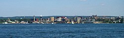 The city of Erie from Lake Erie. | |
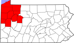 Map of counties in Northwestern Pennsylvania | |
| Coordinates: 42°07′23″N 80°04′54″W / 42.123°N 80.0816°WCoordinates: 42°07′23″N 80°04′54″W / 42.123°N 80.0816°W | |
| Country | United States |
| Commonwealth | Pennsylvania |
| Largest city | Erie |
| Other cities | List |
| Population (2015 est.) | |
| • Total | 938,516 |
| Time zone | UTC-5 (ET) |
| • Summer (DST) | UTC-4 (EDT) |

Northwestern Pennsylvania is a region in the Commonwealth of Pennsylvania, containing 10 counties.[1] The city of Erie is the business center and cultural hub of the region. The compiled population of the region was estimated to be 938,516 in 2015. Although the only county with population growth was Butler, the deficit for all other counties was within 3%. The region also includes the Erie-Meadville, PA Combined Statistical Area.
Northwestern Pennsylvania is home to the Allegheny National Forest, and is the heart of Pennsylvania's oil and gas economy.
Counties[]
- Butler (Pittsburgh, PA USA)
- Clarion
- Crawford (Meadville, PA USA)
- Erie (Erie, PA USA)
- Forest
- Jefferson
- Lawrence (New Castle, PA USA)
- Mercer (Youngstown-Warren-Boardman, OH-PA USA)
- Venango (Oil City, PA USA)
- Warren (Warren, PA USA)
References[]
- ^ "Northwest Pennsylvania". Genealogical Society of Pennsylvania. Retrieved June 8, 2015.

This Pennsylvania state location article is a stub. You can help Wikipedia by . |
Categories:
- Pennsylvania geography stubs
- Regions of Pennsylvania