State College, Pennsylvania
State College, Pennsylvania
Borough of State College | |
|---|---|
    Images from top to bottom, left to right (1) Downtown, (2) Campus buildings on Burrowes Rd., (3) Mural on Heister St. Downtown, (4) Campus building spanning across Atherton Street at White Course | |
| Nickname(s): Lion Country, Happy Valley | |
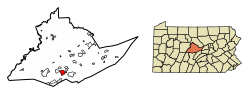 Location of State College in Centre County, Pennsylvania. | |
 State College Location in Pennsylvania | |
| Coordinates: 40°47′29″N 77°51′31″W / 40.79139°N 77.85861°WCoordinates: 40°47′29″N 77°51′31″W / 40.79139°N 77.85861°W | |
| Country | United States |
| State | Pennsylvania |
| County | Centre |
| Incorporated | August 29, 1896 |
| Government | |
| • Mayor | Ronald Filippelli (Interim)[1] |
| Area | |
| • Borough Home rule municipality | 4.56 sq mi (11.80 km2) |
| • Land | 4.56 sq mi (11.80 km2) |
| • Water | 0.00 sq mi (0.00 km2) |
| Elevation | 1,154 ft (352 m) |
| Population | |
| • Borough Home rule municipality | 42,034 |
| • Estimate (2019)[4] | 42,160 |
| • Density | 9,253.73/sq mi (3,572.57/km2) |
| • Urban | 87,454 (US: 335th) |
| • Metro | MSA:158,742 (US: 257th) CSA: 236,577 (US: 124th) |
| Time zone | UTC−5 (EST) |
| • Summer (DST) | UTC−4 (EDT) |
| Zip | 16801, 16802, 16803, 16804, 16805 |
| Area code | 814 |
| FIPS code | 42-73808 |
| School district | State College Area School District |
| Website | www |


State College is a home rule municipality in Centre County in the Commonwealth of Pennsylvania. It is a college town, dominated economically and demographically by the presence of the University Park campus of the Pennsylvania State University (Penn State).
State College is the largest designated borough in Pennsylvania.[5] It is the principal borough of the six municipalities that make up the State College area, the largest settlement in Centre County and one of the principal cities of the greater State College-DuBois Combined Statistical Area with a combined population of 236,577 as of the 2010 United States Census. In the 2010 census, the borough population was 42,034 with approximately 105,000 living in the borough plus the surrounding townships often referred to locally as the "Centre Region." Many of these Centre Region communities also carry a "State College, PA" address although are not part of the borough of State College.[5] "Happy Valley" and "Lion Country" are other terms used to identify the State College area including the borough as well as the townships of College, Harris, Patton, and Ferguson.
History[]
State College evolved from a village to a town to serve the needs of the Pennsylvania State College, founded as the Farmers' High School of Pennsylvania in 1855. State College was incorporated as a borough on August 29, 1896, and has grown with the college, which was renamed The Pennsylvania State University in 1953.
In 1973 State College adopted a home rule charter which took effect in 1976;[6] since then, it has not been governed by the state's Borough Code, although it retains "Borough of State College" as its official name.
The university has a post office address of University Park, Pennsylvania. When Penn State changed its name from College to University in 1953, its president, Milton S. Eisenhower, sought to persuade the town to change its name as well.[7] A referendum failed to yield a majority for any of the choices for a new name, and so the town remains State College. After this, Penn State requested a new name for its on-campus post office in the HUB-Robeson Center from the U.S. Post Office Department. The post office, which has since moved across an alley to the McAllister Building, is the official home of ZIP code 16802 (University Park).

Geography[]

Location[]
State College is situated at an elevation of approximately 1,200 feet (370 m) above sea level.[8] According to the United States Census Bureau, the borough has a total area of 4.5 square miles (12 km2), all of it land. It is surrounded by large tracts of farmland, and an expanse of Appalachian Mountain ranges and forests. Its location within a valley makes it prone to frequent rain and snowfall. Nittany Mountain is part of Pennsylvania's geologic ridge-and-valley province of the Appalachian Mountains.[9] It is (approximately) the geographic center of Pennsylvania.
Neighborhoods[]
Two major sections in State College include the Downtown Improvement District and University Park. Some significant neighborhoods include Highlands, Orchard Park, West End, College Heights, Holmes Foster, South State College, Tusseyview, Greentree, Nittany Hills and Penfield, and Vallamont. Four of these neighborhoods, Orchard Park, Greentree, Tusseyview, and South State College, are included as one area called "Suburban" State College under the National Citizen's Survey.
Downtown[]

Downtown State College, also known as the Downtown Improvement District is the commercial and cultural center of the Borough. The area receives approximately 1.5 to 2 million annual visitors and boasts major festivals such as the Central Pennsylvania Festival for the Arts.[10] Downtown State College boasts a population of around 4,417 people.

Urban composure[]
State College is one of the densest cities of its population in the United States, primarily aided by the presence of numerous high rises downtown along Beaver and College Avenues. The 2010s saw a construction boom downtown, with several mixed-use towers being developed, including the Rise, Metropolitan, Fraser Centre, Here State College (a 15-floor tower on Garner Street), among other projects. Unlike most older towers, many of the newer buildings are mixed-use, with retail on the ground floor, offices on the next couple floors up, and apartments on the top floors.[11][12]
This high rise building boom has drawn debate in the local area. Some residents see it as a boon to increase foot traffic downtown and reduce congestion on the arterial roads leading into the town. Others, however, are skeptical of the developments as they replace historical buildings in the area, losing some of the borough's character.
University Park[]
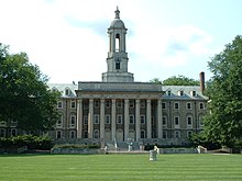
University Park is the largest Penn State campus and the postal address for the University. Notable sites include Old Main, a landmark of the Farmers' High School Historic District, Rec Hall, the Nittany Lion Shrine, the Palmer Museum of Art, Penn State Creamery, Beaver Stadium, and the Bryce Jordan Center, the latter two being on the College Township half of University Park.
Highlands[]
From 1909 to 1932 annexation for the Highlands took place. The area was acclaimed for their plots of land in proximity to the post office. Twenty mansions were built between 1925 to 1933 to attract fraternities while smaller houses were also constructed. The neighborhood terminated around Irvin Avenue, but after World War II expansion was necessary to accommodate for returning soldiers. Today the Highlands sits as the most populated neighborhood in the borough with a population of 9,726 people, 77% of which being in the age range of 18-24-year-olds. The neighborhood also includes a section of the Holmes-Foster-Highlands Historic District.
Orchard Park[]
Orchard Park is a multi-family residential area, and mostly populated by college-aged residents and young professionals. Expansion for the area began in the late 20th century with the population sitting around 4,000 people. The neighborhood is home to two parks and sits adjacent to the Westerly Parkway Plaza which houses many businesses. Orchard Park also houses the South Hills Business School, a YMCA, and the Knights of Columbus, which is used as a location for voters in State College.[13]
West End[]
The West End, also referred to as the Urban Village is an extension of the Downtown and Holmes-Foster areas. Being adjacent to west campus, the West End has a high population of renters, approximately 96.3% of the population. The neighborhood had a population of 2,324 people as of the 2010 US census.[14] The West End also makes up a third of the Holmes-Foster-Highlands Historic District.
College Heights[]
College Heights is a neighborhood and historic district north of campus. The College Heights Historic District was added to the National Register of Historic Places in 1995 which makes up the majority of the area.[15] College Heights is dominated by families of professionals or other Penn State faculty as well as Penn State students due to their proximity to campus.[16] From 1852 to 1920 the neighborhood consisted of only 15 homes just north of Penn State, but in the decade the number of houses had quadrupled to 69. Development continued throughout the later decades to the 2010s where College Heights sat at a population of 1,839 people.[14] The neighborhood also has a park that partly spills into Ferguson Township.

Holmes-Foster[]
Holmes-Foster makes up half of the Holmes–Foster–Highlands Historic District which was added to the National Register of Historic Places in 1995.[15] Holmes-Foster had a population of 1,597 during the 2010 census.[14]
South State College[]
South State College also referred to as the South Neighborhood is shaped by Easterly Parkway, University Dr, and Atherton St forming a triangular shape. The area began expansion around World War II.[17] The neighborhood has a population of 1,313.
Tusseyview[]
Tusseyview is south of South State College and has a population of 995. The neighborhood has three parks, Tussey View Park, South Hills Park, and Nittany Village Park. The area is also home to the State College Friends School, a Quaker school that serves the local school districts.
Greentree[]
Greentree is a neighborhood between Holmes-Foster to the north, Orchard Park to the south, and Ferguson Township to the west. The population was 923 people.[14]
Nittany Hills and Penfield[]
Nittany Hills and Penfield are two sections of the same neighborhood. Nittany Hills constitutes the eastern half while Penfield makes up the western half. The neighborhood is sandwiched between State College South and College Township. The population was 353 people as of the 2010 census.[14][17]
Vallamont[]
Vallamont is a small neighborhood east of the Highlands, west of College Township, and North Nittany Hills. The population was 124 people as of the 2010 census. The high number of residents is attributed to an apartment building being contained with the census borders.[14]
Climate[]
| State College | ||||||||||||||||||||||||||||||||||||||||||||||||||||||||||||
|---|---|---|---|---|---|---|---|---|---|---|---|---|---|---|---|---|---|---|---|---|---|---|---|---|---|---|---|---|---|---|---|---|---|---|---|---|---|---|---|---|---|---|---|---|---|---|---|---|---|---|---|---|---|---|---|---|---|---|---|---|
| Climate chart (explanation) | ||||||||||||||||||||||||||||||||||||||||||||||||||||||||||||
| ||||||||||||||||||||||||||||||||||||||||||||||||||||||||||||
| ||||||||||||||||||||||||||||||||||||||||||||||||||||||||||||
State College has a humid continental climate (Köppen Dfa). Temperatures average 27.2 °F (−2.7 °C) in January and 72.2 °F (22.3 °C) in July.[19] Annual precipitation averages 41.53 inches (105 cm), with 43.8 inches (111 cm) of annual snowfall on average.[19] With a period of record dating back to 1893, the lowest temperature recorded was −20 °F (−29 °C) on February 10, 1899 and the highest was 102 °F (39 °C) on July 17, 1988, and July 9, 1936.[20]
Weather in State College is strongly influenced by the mountain and valley topology of the area. The surrounding mountains cause significantly lower temperatures in the winter, and make summer heat waves much rarer than in the rest of the state. Precipitation is about 20% lower than areas at comparable elevations, again due to the surrounding mountains. Snowfall typically occurs between October and April, but has happened as late as June.[21]
| hideClimate data for State College, Pennsylvania (1991–2020 normals, extremes 1893–present) | |||||||||||||
|---|---|---|---|---|---|---|---|---|---|---|---|---|---|
| Month | Jan | Feb | Mar | Apr | May | Jun | Jul | Aug | Sep | Oct | Nov | Dec | Year |
| Record high °F (°C) | 71 (22) |
74 (23) |
86 (30) |
94 (34) |
93 (34) |
96 (36) |
102 (39) |
101 (38) |
98 (37) |
90 (32) |
81 (27) |
71 (22) |
102 (39) |
| Average high °F (°C) | 33.9 (1.1) |
36.8 (2.7) |
45.6 (7.6) |
59.2 (15.1) |
69.4 (20.8) |
77.0 (25.0) |
81.1 (27.3) |
79.3 (26.3) |
72.3 (22.4) |
60.7 (15.9) |
48.8 (9.3) |
38.4 (3.6) |
58.5 (14.7) |
| Daily mean °F (°C) | 27.2 (−2.7) |
29.1 (−1.6) |
37.0 (2.8) |
49.3 (9.6) |
59.8 (15.4) |
68.1 (20.1) |
72.2 (22.3) |
70.4 (21.3) |
63.2 (17.3) |
51.9 (11.1) |
41.2 (5.1) |
32.2 (0.1) |
50.1 (10.1) |
| Average low °F (°C) | 20.5 (−6.4) |
21.5 (−5.8) |
28.3 (−2.1) |
39.4 (4.1) |
50.3 (10.2) |
59.3 (15.2) |
63.3 (17.4) |
61.6 (16.4) |
54.1 (12.3) |
43.0 (6.1) |
33.5 (0.8) |
26.0 (−3.3) |
41.7 (5.4) |
| Record low °F (°C) | −18 (−28) |
−20 (−29) |
−9 (−23) |
1 (−17) |
27 (−3) |
34 (1) |
40 (4) |
30 (−1) |
28 (−2) |
16 (−9) |
1 (−17) |
−13 (−25) |
−20 (−29) |
| Average precipitation inches (mm) | 2.92 (74) |
2.46 (62) |
3.38 (86) |
3.51 (89) |
3.64 (92) |
4.09 (104) |
3.79 (96) |
4.16 (106) |
3.95 (100) |
3.46 (88) |
2.99 (76) |
3.18 (81) |
41.53 (1,055) |
| Average snowfall inches (cm) | 11.3 (29) |
11.6 (29) |
9.4 (24) |
0.9 (2.3) |
0.0 (0.0) |
0.0 (0.0) |
0.0 (0.0) |
0.0 (0.0) |
0.0 (0.0) |
0.4 (1.0) |
2.6 (6.6) |
7.6 (19) |
43.8 (111) |
| Average precipitation days (≥ 0.01 in) | 13.6 | 11.4 | 12.0 | 13.6 | 14.5 | 12.3 | 12.4 | 11.2 | 10.7 | 11.4 | 10.5 | 12.8 | 146.4 |
| Average snowy days (≥ 0.1 in) | 8.4 | 7.3 | 4.4 | 1.0 | 0.0 | 0.0 | 0.0 | 0.0 | 0.0 | 0.3 | 1.6 | 5.6 | 28.6 |
| Source: NOAA[20][19] | |||||||||||||
Demographics[]
| Historical population | |||
|---|---|---|---|
| Census | Pop. | %± | |
| 1900 | 851 | — | |
| 1910 | 1,425 | 67.5% | |
| 1920 | 2,405 | 68.8% | |
| 1930 | 4,450 | 85.0% | |
| 1940 | 6,226 | 39.9% | |
| 1950 | 17,227 | 176.7% | |
| 1960 | 22,409 | 30.1% | |
| 1970 | 32,833 | 46.5% | |
| 1980 | 36,130 | 10.0% | |
| 1990 | 38,923 | 7.7% | |
| 2000 | 38,420 | −1.3% | |
| 2010 | 42,034 | 9.4% | |
| 2019 (est.) | 42,160 | [4] | 0.3% |
| Sources:[22][23][24] | |||
According to the 2010 census,[24] there were 42,034 people, 12,610 households, and 3,069 families residing in the borough. The population density was 9,258.6 people per square mile (3,574.3/km2). There were 13,007 housing units at an average density of 2,865.0 per square mile (1,106.0/km2). The racial makeup of the borough was 83.2% White, 3.8% Black or African American, 0.2% Native American, 9.8% Asian, 1.0% Other, and 2.0% from two or more races. 3.9% of the population were of Hispanic or Latino ancestry. 22,681 or 54.0% of borough residents were males and 19,353 or 46.0% were females.
A 2014 estimate had the racial makeup of the borough as 78.9% Non-Hispanic White, 5.6% Black or African American, 0.5% Native American and Alaska Native, 11.5% Asian, 0.1% Native Hawaiian and other Pacific Islander, 0.8% Some other race, and 2.2% two or more races. 4.4% were Hispanic or Latino (of any race).[25]
Of the 12,610 households, 9.1% had children under the age of 18 living with them, 18.2% were married couples living together, 3.8% had a female householder with no husband present, 2.4% had a male householder with no wife present, and 75.6% were non-families. 33.6% of all households were made up of individuals, and 5.1% had someone living alone who was 65 years of age or older. The average household size was 2.30 and the average family size was 2.71.
The age distribution of the borough, overwhelmingly influenced by its student population, was 5.1% under the age of 18, 70.6% from 18 to 24, 13.1% from 25 to 44, 6.5% from 45 to 64, and 4.7% who were 65 years of age or older. The median age was 22 years.
The median income for a household in the borough was $23,513, and the median income for a family was $58,953. The per capita income for the borough was $13,336. 46.9% of the population and 9.8% of families were below the poverty line. Out of the total population, 10.6% of those under the age of 18 and 2.2% of those 65 and older were living below the poverty line. However, traditional measures of income and poverty can be very misleading when applied to a community like State College which is dominated by students.
The population of the State College Metropolitan Statistical Area was 153,990 in the 2010 U.S. census.
Economy[]

Pennsylvania State University is the largest single employer in the region, employing over 27,000 full- and part-time workers in 2016. In addition to higher education, other industries in the area include health care, retail, hospitality services, construction, and government.[26]
| # | Employer | # of employees |
|---|---|---|
| 1 | Pennsylvania State University | 27,029 |
| 2 | Mount Nittany Medical Center | 2,365 |
| 3 | State College Area School District | 1,792 |
| 4 | Government of Pennsylvania | 1,704 |
| 5 | Walmart | 732 |
| 6 | Glenn O. Hawbaker Inc. (construction) | 700 |
| 7 | HRI Inc. (asphalt contractor) | 692 |
| 8 | Weis Markets | 631 |
| 9 | Centre County Government | 586 |
| 10 | Geisinger Medical Group | 563 |
Other notable employers include the Federal Government (452 employees), YMCA (446 employees), Wegmans (430 employees), AccuWeather (405 employees), Shaner Corporation (380 employees), McDonald's (263 employees), Giant Food Stores (255 employees), Hotel State College & Company (251 employees), Raytheon (251 employees), Sheetz (251 employees), Foxdale Village (250 employees), State College Borough Government (213 employees), Minitab (211 employees), and Penn State Hershey Medical Group (200 employees).[26]
Arts and culture[]
Events[]

The Central Pennsylvania Festival of the Arts,[27] usually referred to as "Arts Fest", is held downtown every July. The five-day festival features artists from around the country and draws more than 125,000 visitors.[28] Streets are closed off and lined with booths where people can buy paintings, pottery, jewelry, and other hand-made goods. There are also numerous musical performances and plays to take in, and food vendors selling everything from funnel cakes to Indian cuisine.
The Penn State IFC/Panhellenic Dance Marathon, commonly referred to as THON, is a 46-hour Dance Marathon that takes place every February on the University Park campus with the purpose of raising money for the Four Diamonds Foundation.[29] A number of events throughout the year pave the way to February's THON weekend.
Blue-White Football Weekend occurs in April and includes a carnival, fireworks, food vendors, the student entertainment stage, live music, a parade, and more.[30] On game day, an autograph session with the football student-athletes is held in Beaver Stadium, prior to kickoff of the Blue-White football intrasquad scrimmage game.
Some of the other popular annual events in the area include "First Night State College", a New Year's Eve celebration with carved ice sculptures and musical performances that takes place in downtown State College and "Central PA 4th Fest", a day-long event which includes Fourth of July fireworks, crafts, food vendors and entertainers.
On Saturday February 4, 2017, State College became a Guinness World Record holder. Light Up State College organized 5,226 lighted ice luminaries that were displayed across South Allen Street in downtown State College. This is the most ice luminaries in any one location to date. The previous record was held by Vuollerim, Sweden, with 2,652 ice luminaries.
Sports[]

State College is most known for Penn State Nittany Lions football which draws over 100,000 fans to Beaver Stadium on home games.[31] The borough itself is home to the State College Spikes, a minor league baseball team. The team is part of the New York–Penn League and has played in Medlar Field at Lubrano Park, also home to Penn State baseball, since 2006.[32]
| Sport | League | Club | Founded | Venue | League championships | Championship years |
|---|---|---|---|---|---|---|
| Baseball | NYPL | State College Spikes | 2006 | Medlar Field at Lubrano Park | 2 | 2014, 2016 |
| Basketball | NCAA | Penn State Nittany Lions Men's Basketball | 1897 | Bryce Jordan Center | 0 | N/A |
| Basketball | NCAA | Penn State Lady Lion's Women's Basketball | 1965 | Bryce Jordan Center | 0 | N/A |
| Football | NCAA | Penn State Nittany Lions football | 1887 | Beaver Stadium | 2 | 1982, 1986 |
| Ice Hockey | NCAA | Penn State Nittany Lions men's ice hockey | 1939 | Pegula Ice Arena | 0 | N/A |
| Ice hockey | NCAA | Penn State Nittany Lions women's ice hockey | 1996 | Pegula Ice Arena | 0 | N/A |
| Soccer | NCAA | Penn State Nittany Lions men's soccer | 1911 | Jeffrey Field | 0 | N/A |
| Soccer | NCAA | Penn State Nittany Lions Women's Soccer | 1994 | Jeffrey Field | 1 | 2015 |
| Volleyball | NCAA | Penn State Nittany Lions men's volleyball | 1976 | Rec Hall | 2 | 1994, 2008 |
| Volleyball | NCAA | Penn State Nittany Lions women's volleyball | 1976 | Rec Hall | 7 | 1999, 2007, 2008, 2009, 2010, 2013, 2014 |
| Wrestling | NCAA | Penn State Nittany Lions Wrestling | 1909 | Rec Hall | 9 | 1921, 1953, 2011, 2012, 2013, 2014, 2016, 2017, 2018, 2019 |

Jeffrey Field[]
Jeffrey Field is a soccer specific stadium in State College, Pennsylvania that is home to both the Penn State Nittany Lions women's soccer and Penn State Nittany Lions men's soccer programs.[33] Address is University Drive at East Park Avenue.[34]
Rec Hall[]
Rec Hall is a field house located on the University Park campus of the Pennsylvania State University. It was opened on January 15, 1929, and is still in use. It is home to the Penn State Nittany Lions women's and men's volleyball teams, and Penn State Nittany Lions wrestling. Rec Hall has a banked indoor track that of approximately 257 yards around or roughly 6.85 laps/mile.
Pegula Ice Arena[]
The Pegula Ice Arena is a 6,014-seat multi-purpose arena in University Park, Pennsylvania on the campus of Penn State University, opened in October 11, 2013 it replaced the 1,350-seat Penn State Ice Pavilion. The facility is located on the corner of Curtin Road and University Drive near the Bryce Jordan Center.
Beaver Stadium[]
Beaver Stadium is an outdoor college football stadium in University Park, Pennsylvania, on the campus of Pennsylvania State University. It is home to the Penn State Nittany Lions of the Big Ten Conference since 1960. Beaver Stadium has an official seating capacity of 106,572, making it currently the second largest stadium in the Western Hemisphere and the third largest in the world.
Rothrock State Forest[]
The Nittany Mountain Biking Association (NMBA) is active at maintaining and adding trails throughout the local state forest. There are miles of trails through Rothrock State Forest most of which are challenging and not for beginners.
Government[]
Federal[]
At the federal level, State College is in Pennsylvania's 12th congressional district, represented by Republican Fred Keller.
State[]
Republican Jake Corman represents Pennsylvania Senate, District 34, and Democrat Scott Conklin represents Pennsylvania House of Representatives, District 77.
County[]
At the county level, Centre County, Pennsylvania's county seat is in Bellefonte, Pennsylvania. There are three county-level district courts within State College, with the others being Philipsburg, Bellefonte, and Centre Hall.
The current county-level districts are divided as follows, all of which are common pleas courts. The jurisdictions include civil claims and summary offenses. Higher level courts are located in neighboring Bellefonte.[35]
- District 49-1-01, District Judge Carmine W. Prestia
- District 49-2-01, District Judge Casey McClain
- District 49-3-02, District Judge Kelley Gillette-Walker
- District 49-3-03, District Judge Allen Sinclair
- District 49-3-04, District Judge Thomas Jordan
- District 49-3-05, District Judge Steven F. Lachman
Regional[]
The Borough of State College is a member of the Centre Region Council of Governments (CRCOG).[36] Other members are
- College Township
- Ferguson Township
- Halfmoon Township
- Harris Township
- Patton Township
Local[]
At the local level, the Borough of State College[37] government is currently run by the following elected officials:[38]
- Mayor: Ronald Filippelli (Interim)
- President of Council: Evan A. Myers
- Council members:
- Jesse L. Barlow
- David J. Brown
- Catherine G. Dauler
- Janet P. Engeman
- Theresa D. Lafer
- Dan Murphy
Education[]
Public schools[]
State College is served by the State College Area School District which operates nine elementary schools, two middle schools, and one high school in and around State College.[39]
Charter schools[]
- Centre Learning Community Charter School[40]
- Nittany Valley Charter School[41]
- State College Area Delta Program[42][43]
- Wonderland Charter School[44]
- Young Scholars of Central Pennsylvania Charter School[45]
Private schools[]
- Children's House Montessori School
- The Goddard School[46]
- Grace Prep High School[47]
- Kinder Station
- Nittany Christian School[48]
- Our Children's Center Montessori School[49]
- Our Lady of Victory Catholic School[50]
- Park Forest Montessori School[51]
- St. John Catholic School[52]
- Saint Joseph's Catholic Academy[53]
- State College Friends School[54]
Higher and post-secondary education[]
- Penn State University is located partially in the borough of State College.
- South Hills School of Business & Technology[55]
Libraries[]
State College is served by the following libraries:[56]
- American Philatelic Research Library
- Centre County Library & Historical Museum
- Centre County Library Bookmobile
- Centre Hall Area Branch Library
- Holt Memorial Library (Philipsburg)
- Pennsylvania State University Libraries
- Davey Library (physical and mathematical sciences)
- Deike Library (earth and mineral sciences)
- Hammond Library (engineering)
- Pattee and Paterno Libraries (main library)
- Pollock Library (study library)
- Stuckeman Library (architecture and landscape architecture)
- Schlow Centre Region Library
Media[]
State College's daily newspaper is the Centre Daily Times, part of the McClatchy Company chain. There is also a weekly version published as Centre Weekly. An alternative town newspaper is the Centre County Gazette[57] Newspapers of Pennsylvania State University's main campus include The Forum, the student-run Daily Collegian, and Onward State, a student-run digital media blog.[58]
Numerous magazines are published in State College, including State College Magazine,[59] Blue White Illustrated,[60] Centered Magazine,[61] Pennsylvania Business Central,[62] Provisions Magazine,[63] Town & Gown Magazine,[64] and Valley Magazine.[65]
State College is part of the Johnstown/Altoona/State College television market, which is ranked No. 102 in the nation.[66] Television stations broadcasting out of State College include WPSU 3 (PBS) and WHVL-LD 29 (MyNetworkTV) as well as C-NET, Centre County's Government and Education Access Television Network, which broadcasts on two cable channels: CGTV (Government Access TV) on Comcast and Windstream Channel 7 and CETV (Educational Access TV) on Channel 98. WATM-TV 23 (ABC) produces a Centre County focused newscast, anchored from a studio on West College Avenue. WJAC-TV 6 (NBC), WTAJ-TV 10 (CBS), and WWCP-TV 8 (FOX) also maintain satellite studios and offices here.
Infrastructure[]
Transportation[]

State College is located at the junction of Interstate 99/U.S. Route 220 and U.S. Route 322. I-99/US 220 head north to an interchange with Interstate 80 and south towards Altoona. US 322 heads west along with I-99/US 220 and east towards Harrisburg. U.S. Route 322 Business passes east-west through State College on Atherton Street. Pennsylvania Route 26 passes north-south through State College, following the one-way pair of Beaver Avenue northbound and College Avenue southbound. Parking in the downtown area of State College is regulated by on-street parking meters, two off-street parking lots, and four parking garages. The off-street parking lots offer parking with hourly rates while the parking garages offer parking with both hourly rates and monthly permits.[67] Parking in residential areas is regulated by residential parking permits, allowing holders of such permits to park beyond the posted time limits. Some streets near the downtown area allow holders of commuter parking permits to park beyond the posted time limits.[68]
In 2009, the State College metropolitan statistical area (MSA) ranked as the tenth highest in the United States for percentage of commuters who walked to work (8 percent).[69] In 2013, the State College MSA ranked as the fifteenth lowest in the United States for percentage of workers who commuted by private automobile (79.2 percent). During the same year, 9.9 percent of State College area commuters walked to work.[70]
The borough is served by the Centre Area Transportation Authority for local bus service and the University Park Airport for commercial air traffic. Intercity bus service to New York City, Philadelphia, Pittsburgh, and other points across the state is provided by Fullington Trailways, Greyhound Lines, Megabus, and OurBus. The State College Bus Station serving Fullington Trailways and Greyhound Lines is located adjacent to downtown and the Pennsylvania State University campus. Megabus stops in the parking lot of the Walmart along North Atherton Street. State College does not have passenger train service, with the nearest Amtrak stations located in Tyrone (approximately 26 miles away), Huntingdon (approximately 31 miles away) and Lewistown (approximately 32 miles away) serving Amtrak's Pennsylvanian train between Pittsburgh and New York City. Amtrak Thruway Motorcoach service is available via Greyhound Lines from State College to the Harrisburg Transportation Center in Harrisburg, connecting to Amtrak's Keystone Service train to New York City.[71]
Utilities[]
Electricity in State College is provided by West Penn Power, a subsidiary of FirstEnergy.[72] Natural gas service in the borough is provided by Columbia Gas of Pennsylvania, a division of NiSource.[73] The State College Borough Water Authority provides water service to State College along with Patton, Ferguson, College, Harris, and Benner townships. Sewer service in State College is provided by the University Area Joint Authority.[74] Trash and recycling collection is provided by the borough's Public Works department.[75]
Health care[]
The Mount Nittany Medical Center, which has 260 beds and offers emergency, medical, surgical, diagnostic and community services, is located in State College.
Notable people[]
The following individuals were born and/or raised in State College:
|
Sport figures:
|
Others:
|
The following were/are residents of State College:
|
Sport figures:
|
Others:
|
See also[]
- List of college towns
References[]
- ^ Rushton, Geoff (December 16, 2019). "Filippelli Appointed as Interim Mayor of State College". StateCollege.com. Retrieved April 28, 2020.
- ^ "2019 U.S. Gazetteer Files". United States Census Bureau. Retrieved July 28, 2020.
- ^ "U.S. Census website". United States Census Bureau. Retrieved August 6, 2014.
- ^ Jump up to: a b "Population and Housing Unit Estimates". United States Census Bureau. May 24, 2020. Retrieved May 27, 2020.
- ^ Jump up to: a b "State College: Mayor's Welcome". Statecollegepa.us.
- ^ Pennsylvania Code Title 314, Sec. 41.1–101 et seq. Archived December 1, 2005, at the Wayback Machine
- ^ "Quest for National Recognition". Penn State University Libraries. September 15, 2016. Retrieved September 21, 2018.
- ^ "US Gazetteer files: 2010, 2000, and 1990". United States Census Bureau. February 12, 2011. Retrieved April 23, 2011.
- ^ "Pennsylvania State University – Nittany Mountain". Psu.edu.
- ^ "Downtown State College". downtownstatecollege.com.
- ^ "State College, PA – Construction Under Way on Two Downtown High Rises, Preliminary Work Begins for a Third -".
- ^ "State College, PA – Borough Council Continues Discussion of Possible New High-Rise -".
- ^ "Orchard Park". statecollegepa.us.
- ^ Jump up to: a b c d e f "statecollegepa Neighborhood Plans". statecollegepa.us.
- ^ Jump up to: a b "National Register Information System". National Register of Historic Places. National Park Service. July 9, 2010.
- ^ "College Heights Neighborhood Plan". statecollegepa.us.
- ^ Jump up to: a b "PENFIELD NITTANY HILLS PLANS". statecollegepa.us.
- ^ "Pennsylvania State Climatologist – State College Extremes". Pennsylvania State Climatologist. Retrieved April 28, 2013.
- ^ Jump up to: a b c "Station: State College, PA". U.S. Climate Normals 2020: U.S. Monthly Climate Normals (1991-2020). National Oceanic and Atmospheric Administration. Retrieved August 7, 2021.
- ^ Jump up to: a b "NowData – NOAA Online Weather Data". National Oceanic and Atmospheric Administration. Retrieved August 7, 2021.
- ^ "The Climate of State College, Pennsylvania: 1882-1990". Pennsylvania State University. Retrieved April 11, 2021.
- ^ "Number of Inhabitants: Pennsylvania" (PDF). 18th Census of the United States. U.S. Census Bureau. Retrieved November 22, 2013.
- ^ "Pennsylvania: Population and Housing Unit Counts" (PDF). U.S. Census Bureau. Retrieved November 22, 2013.
- ^ Jump up to: a b "U.S. Census website". United States Census Bureau. Retrieved January 31, 2008.
- ^ Bureau, U.S. Census. "U.S. Census website". United States Census Bureau. Retrieved April 14, 2017.
- ^ Jump up to: a b "The top 40 employers in Centre County". Centredaily.com.
- ^ "Home – Central Pennsylvania Festival of the Arts". Arts-festival.com.
- ^ "Home – Central Pennsylvania Festival of the Arts". Arts-festival.com.
- ^ "Fighting Pediatric Cancer". Penn State Hershey. Retrieved August 3, 2012.
- ^ "Penn State Blue-White Game Weekend 2013". LazerPro Digital Media Group. Retrieved August 3, 2012.
- ^ "Beaver Stadium Attendance Up 5,000 Per Game in 2014 – Onward State". Onwardstate.com. December 2, 2014.
- ^ "Ball Park History | State College Spikes". The Official Site of Minor League Baseball. January 30, 2019. Archived from the original on January 30, 2019.
- ^ "GOPSUSPORTS.com :: Official Athletic Site of Penn State". Gosusports.com. Archived from the original on November 26, 2015. Retrieved June 9, 2016.
- ^ "Jeffrey Field". Foursquare.com. Retrieved June 9, 2016.
- ^ Centre County Government: District Judges. Co.centre.pa.us. Retrieved March 30, 2011.
- ^ "COG – Council of Governments". Crcog.net.
- ^ "Borough of State College Government – Official Website". Statecollegepa.us.
- ^ Council Member Directory | Borough of State College Government statecollegepa.us
- ^ State College Area School District. Scasd.org. Retrieved March 30, 2011.
- ^ "Home". CLC Charter School.
- ^ "Nittany Valley Charter School". Nittany Valley Charter School.
- ^ Although not officially a charter school, SCASD refers to it as one. The school is run by the school district and is officially an "alternative program" within the public high school.
- ^ "Delta Program High School / The Delta Program". Scasd.org.
- ^ "Archived copy". Archived from the original on October 31, 2018. Retrieved December 9, 2018.CS1 maint: archived copy as title (link)
- ^ "YSCP Charter School – YSCP Charter School". Yscp.org.
- ^ "The Goddard School – Private Preschool & Educational Daycare". Goddardschool.com.
- ^ Grace Prep High School : An Innovative, Award-winning School of Academic Excellence. Graceprep.com (May 26, 2010). Retrieved March 30, 2011.
- ^ Nittany Christian School. Nittanychristian.com (October 2, 2006). Retrieved March 30, 2011.
- ^ "Our Children's Center – A Montessori Preschool – Downtown State College Pennsylvania". Occmontessori.org.
- ^ "Our Lady of Victory Catholic School K-8 / Overview". Olvcatholicschool.org.
- ^ "Park Forest Montessori School: Quality preschool and kindergarten in State College, Pennsylvania". Parkforestmontessori.com.
- ^ "Faith. Service. Academics". St. John the Evangelist Catholic School.
- ^ "Home". Stjoeacad.org. June 12, 2018. Retrieved October 31, 2018.
- ^ [1]
- ^ "Home". South Hills School of Business & Technology.
- ^ Libraries. Statecollege.com. Retrieved March 30, 2011.
- ^ "State College, PA – Centre County Gazette – Reporting Centre County". Statecollege.com.
- ^ "Pennsylvania Newspapers". NewsLink.org. Retrieved March 20, 2011.
- ^ State College Magazine ‘’State College Magazine’’
- ^ Blue White Illustrated Blue White Illustrated
- ^ Centered Magazine Centered Magazine
- ^ Pennsylvania Business Central Pennsylvania Business Central
- ^ Provisions Magazine Provisions Magazine
- ^ Town & Gown Magazine Town & Gown Magazine
- ^ Valley Magazine Valley Magazine
- ^ Nielsen | Local Television Market Universe Estimates Archived March 4, 2016, at the Wayback Machine
- ^ "Downtown Parking". State College, Pennsylvania. Retrieved September 6, 2019.
- ^ "Neighborhood Parking". State College, Pennsylvania. Retrieved September 6, 2019.
- ^ "Commuting in the United States: 2009" (PDF). American Community Survey Reports. September 2011. Archived from the original (PDF) on July 26, 2017. Retrieved December 26, 2017.
- ^ McKenzie, Brian (August 2015). "Who Drives to Work? Commuting by Automobile in the United States: 2013" (PDF). American Survey Reports. Retrieved December 26, 2017.
- ^ "Pennsylvanian schedule" (PDF). Amtrak. Retrieved September 11, 2019.
- ^ "Electric Service Tariff" (PDF). West Penn Power. July 15, 2019. p. 9. Retrieved September 6, 2019.
- ^ "Rates and Rules" (PDF). Columbia Gas of Pennsylvania. June 27, 2019. p. 14. Retrieved September 6, 2019.
- ^ "Water & Sewer". State College, Pennsylvania. Retrieved September 6, 2019.
- ^ "Refuse & Recycling". State College, Pennsylvania. Retrieved September 6, 2019.
External links[]
| Wikivoyage has a travel guide for State College. |
| Wikimedia Commons has media related to State College, Pennsylvania. |
- Borough of State College Government website
- StateCollege.com – news and information website
- Centre Daily Times
- Central Pennsylvania Convention & Visitors Bureau
- Chamber of Business & Industry of Centre County
- Downtown State College Improvement District
- Map 536 *Augmented by Wood, C. R. (1980), Summary groundwater resources of Centre County, Pennsylvania, Pennsylvania Geological Survey, 4th ser., Water Resource Report 48, 60 p.
| show Articles relating to State College, Pennsylvania |
|---|


| show Authority control |
|---|
- State College, Pennsylvania
- 1855 establishments in Pennsylvania
- Academic enclaves
- Home Rule Municipalities in Pennsylvania
- Home Rule Municipalities in Centre County, Pennsylvania
- Pennsylvania State University
- Populated places established in 1855