Cameron County, Pennsylvania
Cameron County | |
|---|---|
U.S. county | |
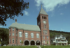 Cameron County Courthouse in Emporium | |
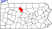
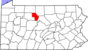 Location within the U.S. state of Pennsylvania | |
 Pennsylvania's location within the U.S. | |
| Coordinates: 41°26′N 78°12′W / 41.44°N 78.2°W | |
| Country | |
| State | |
| Founded | March 29, 1860 |
| Named for | Simon Cameron |
| Seat | Emporium |
| Largest borough | Emporium |
| Area | |
| • Total | 398 sq mi (1,030 km2) |
| • Land | 396 sq mi (1,030 km2) |
| • Water | 2.2 sq mi (6 km2) 0.5%% |
| Population | |
| • Estimate (2018) | 4,492 |
| • Density | 12/sq mi (5/km2) |
| Time zone | UTC−5 (Eastern) |
| • Summer (DST) | UTC−4 (EDT) |
| Congressional district | 15th |
| Website | www |
| Designated | September 14, 1982[1] |

Cameron County is a county located in the U.S. state of Pennsylvania. As of the 2010 census, the population was 5,085,[2] making it Pennsylvania's least populous county. Its county seat is Emporium.[3] The county was created on March 29, 1860, from parts of Clinton, Elk, McKean, and Potter Counties. It is named for Senator Simon Cameron.
Geography[]
According to the U.S. Census Bureau, the county has a total area of 398 square miles (1,030 km2), of which 396 square miles (1,030 km2) is land and 2.2 square miles (5.7 km2) (0.5%) is water.[4] It has a warm-summer humid continental climate (Dfb) and average monthly temperatures in Emporium range from 24.2 °F in January to 69.3 °F in July, while in Driftwood they range from 24.9 °F in January to 69.9 °F in July. [1]
Adjacent counties[]
- McKean County (north)
- Potter County (northeast)
- Clinton County (east)
- Clearfield County (south)
- Elk County (west)
Major roads[]
Demographics[]
| Historical population | |||
|---|---|---|---|
| Census | Pop. | %± | |
| 1870 | 4,273 | — | |
| 1880 | 5,159 | 20.7% | |
| 1890 | 7,238 | 40.3% | |
| 1900 | 7,048 | −2.6% | |
| 1910 | 7,644 | 8.5% | |
| 1920 | 6,297 | −17.6% | |
| 1930 | 5,307 | −15.7% | |
| 1940 | 6,852 | 29.1% | |
| 1950 | 7,023 | 2.5% | |
| 1960 | 7,586 | 8.0% | |
| 1970 | 7,096 | −6.5% | |
| 1980 | 6,674 | −5.9% | |
| 1990 | 5,913 | −11.4% | |
| 2000 | 5,974 | 1.0% | |
| 2010 | 5,085 | −14.9% | |
| 2020 | 4,547 | −10.6% | |
| U.S. Decennial Census[5] 1790-1960[6] 1900-1990[7] 1990-2000[8] 2010-2017[2] | |||
As of the 2000 census,[9] there were 5,974 people, 2,465 households, and 1,624 families residing in the county. The population density was 15 people per square mile (6/km2). There were 4,592 housing units at an average density of 12 per square mile (4/km2). The racial makeup of the county was 98.83% White, 0.35% Black or African American, 0.13% Native American, 0.12% Asian, 0.05% Pacific Islander, 0.05% from other races, and 0.47% from two or more races. 0.57% of the population were Hispanic or Latino of any race. 26.5% were of German, 13.5% American, 13.3% Italian, 10.9% Irish, 8.2% English and 5.8% Polish ancestry.
There were 2,465 households, out of which 27.70% had children under the age of 18 living with them, 52.40% were married couples living together, 9.20% had a female householder with no husband present, and 34.10% were non-families. 30.10% of all households were made up of individuals, and 15.40% had someone living alone who was 65 years of age or older. The average household size was 2.39 and the average family size was 2.96.
In the county, the population was spread out, with 24.50% under the age of 18, 6.00% from 18 to 24, 24.90% from 25 to 44, 24.80% from 45 to 64, and 19.80% who were 65 years of age or older. The median age was 41 years. For every 100 females there were 96.60 males. For every 100 females age 18 and over, there were 94.60 males.
Law and government[]
County Party Registration[]
As of August 17, 2020 there were a total of 3,001 registered voters in Cameron County.[11]
County-row offices[]
- County Commissioners: Lori J. Reed, Chairman (R); James D. Moate (R); Ann M. Losey (D)
- Sheriff: Allen Neyman (R)
- Prothonotary/Clerk/Register/Recorder: Mary Grace Olay (R)
- Treasurer: Staci Brown (R)
- District Attorney: Paul J. Malizia (R)
State Senate[]
- Joe Scarnati III, Republican, Pennsylvania's 25th Senatorial District
State House of Representatives[]
- Martin T. Causer, Republican, Pennsylvania's 67th Representative District
United States House of Representatives[]
United States Senate[]
- Patrick Toomey, Republican
- Bob Casey, Democrat
Education[]
Public school districts[]
- Cameron County School District
- There are 11 public cyber charter schools in Pennsylvania that are available for free statewide, to children K-12. See: Education in Pennsylvania.
Recreation[]
There are three Pennsylvania state parks that are partly in Cameron County.
- Bucktail State Park Natural Area is a 75-mile (121-km) scenic route along Pennsylvania Route 120 stretching from Lock Haven in Clinton County to Emporium the county seat of Cameron County.
- Sinnemahoning State Park
- Sizerville State Park
- both of these state parks straddle the Cameron and Potter County line.
The West Creek Rail Trail has been built on the abandoned rail corridor between Emporium and St. Mary's in Elk County. It provides a paved surface with guard rails and is suitable for hiking or biking in the warm seasons or snowmobiling in winter.[12]
The Fred Woods Trail offers a 4.57 mile loop of blazed trail with scenic valley views and a challenging section running through unique rock formations. The trailhead is accessed off Mason Hill Road above Driftwood, PA.[13][14][15]
Communities[]

Under Pennsylvania law, there are four types of incorporated municipalities: cities, boroughs, townships, and, in at most two cases, towns. The following boroughs and townships are located in Cameron County:
Boroughs[]
Townships[]
Census-designated place[]
Population ranking[]
The population ranking of the following table is based on the 2010 census of Cameron County.[16]
† county seat
| Rank | City/Town/etc. | Population (2010 Census) | Municipal type | Incorporated |
|---|---|---|---|---|
| 1 | † Emporium | 2,073 | Borough | 1864 |
| 2 | Prospect Park | 327 | CDP | |
| 3 | Driftwood | 67 | Borough | 1872 |
Notable people[]
- Tom Mix
- Joseph T. McNarney
References[]
- ^ "PHMC Historical Markers Search" (Searchable database). Pennsylvania Historical and Museum Commission. Commonwealth of Pennsylvania. Retrieved 2014-01-25.
- ^ Jump up to: a b "State & County QuickFacts". United States Census Bureau. Archived from the original on July 8, 2011. Retrieved November 16, 2013.
- ^ "Find a County". National Association of Counties. Archived from the original on 2011-05-31. Retrieved 2011-06-07.
- ^ "2010 Census Gazetteer Files". United States Census Bureau. August 22, 2012. Retrieved March 5, 2015.
- ^ "U.S. Decennial Census". United States Census Bureau. Retrieved March 5, 2015.
- ^ "Historical Census Browser". University of Virginia Library. Retrieved March 5, 2015.
- ^ Forstall, Richard L., ed. (March 24, 1995). "Population of Counties by Decennial Census: 1900 to 1990". United States Census Bureau. Retrieved March 5, 2015.
- ^ "Census 2000 PHC-T-4. Ranking Tables for Counties: 1990 and 2000" (PDF). United States Census Bureau. April 2, 2001. Retrieved March 5, 2015.
- ^ "U.S. Census website". United States Census Bureau. Retrieved 2008-01-31.
- ^ Leip, David. "Dave Leip's Atlas of U.S. Presidential Elections". uselectionatlas.org. Retrieved 21 November 2018.
- ^ Pennsylvania Department of State, Voting and Election Statistics, accessed August 23, 2020
- ^ "Archived copy". Archived from the original on 2015-02-19. Retrieved 2015-02-19.CS1 maint: archived copy as title (link)
- ^ http://www.dcnr.state.pa.us/cs/groups/public/documents/document/dcnr_003252.pdf
- ^ "Fred Woods Trail". VisitPA - #visitPA. Archived from the original on 22 November 2018. Retrieved 21 November 2018.
- ^ "Fred Woods Trail Description". www.wapitiwoods.com. Archived from the original on 22 November 2018. Retrieved 21 November 2018.
- ^ "2010 U.S. Census website". United States Census Bureau. Retrieved 2013-02-10.
External links[]
| Wikimedia Commons has media related to Cameron County, Pennsylvania. |
- Official Cameron County website
- Cameron County Chamber of Commerce website
- Pennsylvania Department of Transportation, Bureau of Planning and Research, Geographic Information Division, "2019 General Highway Map of Cameron County". Note: shows boroughs, townships, roads, villages, some streams.
- Sizerville & Portage Township - A website dedicated to the history of Sizerville & Portage Township, Cameron County Pennsylvania
| show Municipalities and communities of Cameron County, Pennsylvania, United States |
|---|

Coordinates: 41°26′N 78°12′W / 41.44°N 78.20°W
| show Authority control |
|---|
- Pennsylvania counties
- Cameron County, Pennsylvania
- 1860 establishments in Pennsylvania
- Populated places established in 1860
- Counties of Appalachia