Fayette County, Pennsylvania
Fayette County | |
|---|---|
U.S. county | |
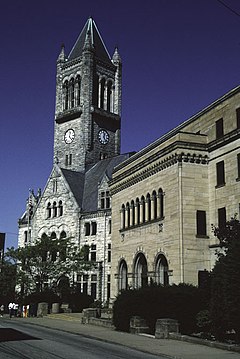 Fayette County Courthouse | |
 Seal | |
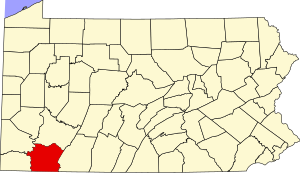 Location within the U.S. state of Pennsylvania | |
 Pennsylvania's location within the U.S. | |
| Coordinates: 39°55′N 79°39′W / 39.92°N 79.65°W | |
| Country | |
| State | |
| Founded | September 26, 1783 |
| Named for | Marquis de Lafayette |
| Seat | Uniontown |
| Largest city | Uniontown |
| Area | |
| • Total | 798 sq mi (2,070 km2) |
| • Land | 790 sq mi (2,000 km2) |
| • Water | 8.0 sq mi (21 km2) 1.0%% |
| Population | |
| • Estimate (2019) | 129,274 |
| • Density | 169/sq mi (65/km2) |
| Time zone | UTC−5 (Eastern) |
| • Summer (DST) | UTC−4 (EDT) |
| Congressional district | 14th |
| Website | www |

Fayette County is a county of the U.S. state of Pennsylvania. Fayette County is located in southwestern Pennsylvania, adjacent to Maryland and West Virginia. As of the 2010 census, the population was 136,606.[1] Its county seat is Uniontown.[2] The county was created on September 26, 1783, from part of Westmoreland County and named after the Marquis de Lafayette.[3]
Fayette County is part of the Pittsburgh, PA Metropolitan Statistical Area. The southern border of Fayette County is also the southern border of Pennsylvania at both the Pennsylvania–Maryland state line (Mason–Dixon line) and the Pennsylvania–West Virginia state line.
History[]
The first Europeans in Fayette County were explorers, who had used an ancient American Indian trail that bisected the county on their journey across the Appalachian Mountains. In 1754, when control of the area was still in dispute between France and Great Britain, 22-year-old George Washington fought against the French at the Battle of Jumonville Glen and Fort Necessity. British forces under Washington and General Edward Braddock improved roads throughout the region, making the future Fayette County an important supply route.
During the American Revolution, Fayette County was plagued by attacks from British-allied Indians and remained isolated as a frontier region. Also retarding settlement was a border dispute with Virginia; Virginia's District of West Augusta and Pennsylvania's Westmoreland County both claimed the area. In 1780 the dispute was settled by the federal government in favor of Pennsylvania, and Fayette County was formed from Westmoreland County in 1783.
Fayette County settlers provided the new United States government with an early test of authority in the 1793 Whiskey Rebellion, when farmers rebelled against tax collectors to protest a new liquor tax. President George Washington called out the militias to restore order. However, they were talked out of any violent action by owner of Friendship Hill and future Secretary of the Treasury, Albert Gallatin. Fayette County continued to be important to travelers in the early 1800s. The National Road provided a route through the mountains of the county for settlers heading west. The shipyards in Brownsville on the Monongahela River built ships for both the domestic and international trade.
As Pittsburgh developed its industries in the mid-19th century, Fayette County became a center of coal mining and coke production. From the 1880s to the early 1900s, the area's great expansion in steel production became nationally important, and labor unions shaped national policies. Both new European immigrants and African Americans in the Great Migration from the rural South were attracted to the Pittsburgh area for industrial jobs. The historic Scottish and German farming communities established in the earlier 19th century were soon overshadowed by the wave of immigrants from Southern and Eastern Europe. The region's wealth has been concentrated largely among the old English and Scottish families who had established businesses and political power in Pittsburgh prior to and in the advent of industrialization, often building the new manufacturing concerns, as did Andrew Carnegie.
By World War II, Fayette County had a new unionized working class that enjoyed increased prosperity. In the 1950s, however, the coal industry fell into decline. In the 1970s, the restructuring and collapse of American steel resulted in a massive loss of industrial jobs and hard times in the area. The population has declined since the peak in 1940, as residents have had to move elsewhere for work. The loss of union jobs caused many working families to drop out of the middle class. Only a few mines are being worked in the 21st century, but natural resources remain crucial to the local economy. The region is slowly transitioning toward the service sector, with an increase in jobs in fields such as telemarketing.
Geography[]
According to the U.S. Census Bureau, the county has a total area of 798 square miles (2,070 km2), of which 790 square miles (2,000 km2) is land and 8.0 square miles (21 km2) (1.0%) is water.[4] The western portion of the county contains rolling foothills and two valleys along the Monongahela and Youghiogheny rivers. The eastern portion of the county is highly mountainous and forested. Many coal mines are located within the area.[5]
Adjacent counties[]
- Westmoreland County (north)
- Somerset County (east)
- Garrett County, Maryland (southeast)
- Preston County, West Virginia (south)
- Monongalia County, West Virginia (southwest)
- Greene County (west)
- Washington County (northwest)
National protected areas[]
- Fort Necessity National Battlefield
- Friendship Hill National Historic Site
Climate[]
Fayette has a humid continental climate (Dfa/Dfb).
| hideClimate data for Uniontown, Pennsylvania (1981-2010; Extremes 1974-present) | |||||||||||||
|---|---|---|---|---|---|---|---|---|---|---|---|---|---|
| Month | Jan | Feb | Mar | Apr | May | Jun | Jul | Aug | Sep | Oct | Nov | Dec | Year |
| Record high °F (°C) | 79 (26) |
77 (25) |
88 (31) |
93 (34) |
93 (34) |
97 (36) |
102 (39) |
102 (39) |
99 (37) |
95 (35) |
88 (31) |
77 (25) |
102 (39) |
| Average high °F (°C) | 39 (4) |
43 (6) |
51 (11) |
63 (17) |
72 (22) |
81 (27) |
84 (29) |
83 (28) |
76 (24) |
65 (18) |
54 (12) |
43 (6) |
63 (17) |
| Average low °F (°C) | 20 (−7) |
22 (−6) |
28 (−2) |
37 (3) |
46 (8) |
56 (13) |
60 (16) |
59 (15) |
51 (11) |
40 (4) |
32 (0) |
24 (−4) |
40 (4) |
| Record low °F (°C) | −22 (−30) |
−16 (−27) |
−3 (−19) |
15 (−9) |
23 (−5) |
33 (1) |
37 (3) |
34 (1) |
29 (−2) |
16 (−9) |
−1 (−18) |
−14 (−26) |
−22 (−30) |
| Average precipitation inches (mm) | 2.8 (71) |
2.7 (69) |
3.8 (97) |
4.0 (100) |
4.4 (110) |
4.3 (110) |
4.8 (120) |
3.9 (99) |
3.6 (91) |
2.9 (74) |
3.5 (89) |
3.2 (81) |
43.9 (1,111) |
| Average snowfall inches (cm) | 8.4 (21) |
7.2 (18) |
4.6 (12) |
0.4 (1.0) |
0.0 (0.0) |
0.0 (0.0) |
0.0 (0.0) |
0.0 (0.0) |
0.0 (0.0) |
0.0 (0.0) |
0.9 (2.3) |
4.4 (11) |
25.9 (65.3) |
| [citation needed] | |||||||||||||
Demographics[]
| Historical population | |||
|---|---|---|---|
| Census | Pop. | %± | |
| 1790 | 13,318 | — | |
| 1800 | 20,159 | 51.4% | |
| 1810 | 24,714 | 22.6% | |
| 1820 | 27,285 | 10.4% | |
| 1830 | 29,172 | 6.9% | |
| 1840 | 33,574 | 15.1% | |
| 1850 | 39,112 | 16.5% | |
| 1860 | 39,909 | 2.0% | |
| 1870 | 43,284 | 8.5% | |
| 1880 | 58,842 | 35.9% | |
| 1890 | 80,006 | 36.0% | |
| 1900 | 110,412 | 38.0% | |
| 1910 | 167,449 | 51.7% | |
| 1920 | 188,104 | 12.3% | |
| 1930 | 198,542 | 5.5% | |
| 1940 | 200,999 | 1.2% | |
| 1950 | 189,899 | −5.5% | |
| 1960 | 169,340 | −10.8% | |
| 1970 | 154,667 | −8.7% | |
| 1980 | 159,417 | 3.1% | |
| 1990 | 145,351 | −8.8% | |
| 2000 | 148,645 | 2.3% | |
| 2010 | 136,606 | −8.1% | |
| 2019 (est.) | 129,274 | [6] | −5.4% |
| U.S. Decennial Census[7] 1790-1960[8] 1900-1990[9] 1990-2000[10] 2010-2019[1] | |||
As of the 2010 census,[11] there were 136,606 people, 59,969 households, and 41,198 families residing in the county. The population density was 188 people per square mile (73/km2). There were 66,490 housing units at an average density of 84 per square mile (32/km2). The racial makeup of the county was 93.30% White, 4.71% Black or African American, 0.11% Native American, 0.22% Asian, 0.01% Pacific Islander, 0.11% from other races, and 2.33% from two or more races. 1.38% of the population were Hispanic or Latino of any race. 19.8% were of German, 13.2% Italian, 11.4% Irish, 9.2% American, 8.4% Polish, 7.9% English and 6.6% Slovak ancestry.
There were 59,969 households, out of which 28.70% had children under the age of 18 living with them, 51.80% were married couples living together, 12.40% had a female householder with no husband present, and 31.30% were non-families. 28.00% of all households were made up of individuals, and 14.50% had someone living alone who was 65 years of age or older. The average household size was 2.43 and the average family size was 2.96.
In the county, the population was spread out, with 22.70% under the age of 18, 7.70% from 18 to 24, 27.20% from 25 to 44, 24.20% from 45 to 64, and 18.10% who were 65 years of age or older. The median age was 40 years. For every 100 females, there were 91.80 males. For every 100 females age 18 and over, there were 87.60 males.
A study released in 2009 by PathWays PA, in partnership with the Pennsylvania Department of Labor and Industry, found that 35% of families in Fayette County were economically distressed, that is, failing to earn a wage that would adequately provide food, shelter, child care, health care, and other basic necessities.[12]
- County poverty demographics
According to research by , which is a legislative Agency of the Pennsylvania General Assembly, the poverty rate for Fayette County was 20.2% in 2014.[13] The statewide poverty rate was 13.6% in 2014. The 2012 childhood poverty rate by school district was: Albert Gallatin Area School District – 61.4%, Brownsville Area School District – 64.7%, Connellsville Area School District – 55.7%, Frazier School District – 40.5%, Laurel Highlands School District – 59.9% and Uniontown Area School District – 55.1% of pupils living at 185% or below than the Federal Poverty Level.[14]
Amongst Appalachian Regional Commission counties, Fayette is easily the most populous to be listed as “At-Risk” or as “Distressed”, containing over fifty percent more people than its nearest rival “At-Risk” county, Ohio's Scioto County, and more than twice the population of the most populous “Distressed” ARC county, Ohio's Athens County.
Fayette County's live birth rate was 1,877 births in 1990. The Fayette County's live birth rate in 2000 was 1,538 births, while in 2011 it had declined to 1,366 babies.[15] Over the past 50 years (1960 to 2010), rural Pennsylvania saw a steady decline in both the number and proportion of residents under 18 years old. In 1960, 1.06 million rural residents, or 35 percent of the rural population, were children. While Fayette is included in the Pittsburgh metropolitan area, 47.9% of the population in 2010 was designated as rural by the U.S. Census Bureau.[16]
Government[]
The County of Fayette is governed by a three-member publicly elected commission. The three commissioners serve in both executive and legislative capacities. By state law, the commission must have a minority party member, guaranteeing a political split. Each member serves a four-year term. Current commissioners are Democrat Vince Vicites and Republicans David Lohr and Scott Dunn.
In October 2015, Sidney Bush, the first African American elected to county office, was sworn in as controller. She is a longtime county employee.[17]
The Fayette County Court of Common Pleas serves as the primary judicial arm in the region. Judges are elected to ten-year terms in accordance with Commonwealth law. Additionally, district judges serve throughout the county and rule on minor offenses. Current judges are President Judge John F. Wagner Jr., Steve P. Leskinen, Nancy Vernon, Linda Cordaro, and Joseph M. George Jr.[18]
Politics[]
As of November 2008, there were 91,386 registered voters in Fayette County.[21]
- Democratic: 62,879 (68.81%)
- Republican: 21,932 (24.00%)
- Other Parties: 6,575 (7.19%)
Fayette County tends to be Democratic-leaning in statewide and national elections. While Democratic politics are entrenched because of a strong union history, the county is generally socially conservative. Along with the rest of Western Pennsylvania, the county has been trending steadily towards the Republicans since 1996.[22] At the presidential level, the Democratic candidate won by over 15 points in every election from 1932 through 2004 except 1972, usually winning by 25 points or more. Since then, the Republican party has continued to improve in each successive election, and the Republican nominee won the county in 2008 and 2012 even as Barack Obama carried the state and the nation. In 2016, Republican Donald Trump won the county by a massive margin of 31 points, carrying the county 64–33. Four years later, he improved on his margin, winning 66.4-32.9.
State representatives[23][]
Serve 2 year terms in Pennsylvania House of Representatives
- Bud Cook, Republican, 49th District[24]
- Pam Snyder, Democrat, 50th District
- , Republican, 51st District
- Ryan Warner, Republican, 52nd District
State senator[23][]
- Pat Stefano, Republican, 32nd district serves 4-year term in Pennsylvania Senate.
U.S. Representative[]
- Guy Reschenthaler, Republican (14th district)
U.S. Senators[]
Serves six year terms in U.S. Senate
- Pat Toomey, Republican
- Bob Casey Jr., Democratic
Education[]
Colleges and universities[]
- Penn State Fayette, The Eberly Campus is a Commonwealth Campus of the Pennsylvania State University system located in Lemont Furnace. Penn State Fayette is the only four-year (bachelors) degree granting institution in Fayette County.
Public school districts[]
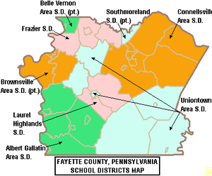
- Albert Gallatin Area School District
- Belle Vernon Area School District (also in Westmoreland County)
- Brownsville Area School District (also in Washington County)
- Connellsville Area School District ( biggest school in Fayette county)
- Frazier School District
- Laurel Highlands School District
- Southmoreland School District (also in Westmoreland County)
- Uniontown Area School District
In October 2015, Pennsylvania Auditor General Eugene DePasquale reported that 23 public schools in the county are among the 561 academically challenged schools that have been overlooked by the Pennsylvania Department of Education.[25][26] He also reported the Pennsylvania Department of Education failed to take any action to remediate the poorly performing schools to raise student academic achievement or to provide them with targeted professional assistance.[27] The failing schools were operated by: Albert Gallatin Area School District 4 schools; Brownsville Area School District 3 schools; Connellsville Area School District 9 schools; Laurel Highlands School District 4 schools and Uniontown Area School District 3 schools.
- Opportunity Scholarship Tax Credit Program
Fifteen (15) public schools in Fayette County were on the bottom 15% academic achievement schools list published by the Pennsylvania Department of Education each school year. Students attending these schools may be eligible for Opportunity Scholarships to attend a better performing school in a neighboring school district or a private school.[28] The scholarships are limited to those students whose family's income is less than $60,000 annually, with another $12,000 allowed per dependent. Maximum scholarship award is $8,500, with special education students receiving up to $15,000 for a year's tuition. Parents pay any difference between the scholarship amount and the receiving school's tuition rate. Funding for the scholarships comes from donations by businesses which receive a state tax credit for donating. In 2015, Albert Gallatin Area School District had 5 schools on the list. Brownsville Area School District 3 schools on the statewide lowest achievement list. Connellsville Area School District 5 of its elementary schools on the list. Uniontown Area School District 2 schools: Lafayette Elementary School and Lafayette Middle School on the lowest achievement list.[29]
- Consolidation study
The Pennsylvania House of Representatives ordered school district consolidation study, which was performed by The Education Management Group, LLC. It was provoked by a 14.30% decline of the 2000–01 pupil population in the county's six public school districts by 2011. Multiple state projections found a continual decline over the next ten years due to a declining birth rate.[30] Fayette County has two Career and Technology Centers that appear to overlap. If the Connellsville Career and Technical Center were eliminated, the savings in salaries and benefits alone would be significantly greater than $2 million, not counting the savings in utilities from closure of the facility. Savings was projected to be in the tens of million each year, largely due to shedding duplicate administration positions.[31] By 2015, no Fayette County public school district consolidations had occurred.
Public cyber charter schools[]
Students may attend any of the 13 public cyber charter schools operating in the Commonwealth of Pennsylvania in 2015.[32][33] The cyber charter schools provide the pupil with a computer and internet access, as well as, other materials needed. As with all public schools in Pennsylvania, students must participate in the annual school testing of the Pennsylvania System of School Assessments (PSSAs) (3rd–8th grades) or the Keystone Exams (9th–12th grades).
Private schools[]
- Apostolic Christian Academy - Dunbar
- Bible Baptist Academy - Uniontown
- Champion Christian School - Champion
- Chestnut Ridge Christian Academy - Uniontown
- Connellsville Area Catholic School - Connellsville
- Geibel Catholic High School - Connellsville
- Mount Carmel Christian School - Mount Pleasant
- Mount Moriah Christian School - Smithfield
- Mount Zion Christian Academy - Acme
- New Meadow Run Parochial School - Farmington
- Spring Valley School - Farmington
- St John Evangelist School - Uniontown
- Verna Montessori School - Prittstown
Intermediate unit[]
Fayette County is served by Intermediate Unit #1 which provides a wide variety of services to public, charter and private schools in the region. Early screening, special educations services, speech and hearing therapy and driver education are available. Services for children during the preschool years are provided without cost to their families when the child is determined to meet eligibility requirements. The IU1 also provides the state mandated multiple background screenings for potential school employees. A variety of professional development services are also available to the schools' employees. [1]
Transportation[]
While Fayette County is a generally rural area and is not directly tied into the interstate system, it features four-lane access to the city of Pittsburgh and several of its major suburban areas. State highway plans call for the establishment of direct freeway connections with Pittsburgh to the north and Morgantown, West Virginia to the south.
Major highways[]
Public transportation[]
The primary provider of mass transportation within the region is Fayette Area Coordinated Transportation, which features local bus routes as well as four times-daily commuter service to Pittsburgh. Amtrak rail service along the Chicago-to-Washington-via-Cleveland Capitol Limited route stops at Connellsville Station. General aviation services are also provided at the Joseph A. Hardy Connellsville Airport.
Municipalities[]

Under Pennsylvania law, there are four types of incorporated municipalities: cities, boroughs, townships, and, in at most two cases, towns. The following cities, boroughs and townships are located in Fayette County:
Cities[]
- Connellsville
- Uniontown (county seat)
Boroughs[]
- Belle Vernon
- Brownsville
- Dawson
- Dunbar
- Everson
- Fairchance
- Fayette City
- Markleysburg
- Masontown
- Newell
- Ohiopyle
- Perryopolis
- Point Marion
- Seven Springs (partly in Somerset County)
- Smithfield
- South Connellsville
- Vanderbilt
Townships[]
- Brownsville
- Bullskin
- Connellsville
- Dunbar
- Franklin
- Georges
- German
- Henry Clay
- Jefferson
- Lower Tyrone
- Luzerne
- Menallen
- Nicholson
- North Union
- Perry
- Redstone
- Saltlick
- South Union
- Springfield
- Springhill
- Stewart
- Upper Tyrone
- Washington
- Wharton
Census-designated places[]
Census-designated places are geographical areas designated by the U.S. Census Bureau for the purposes of compiling demographic data. They are not actual jurisdictions under Pennsylvania law. Other unincorporated communities, such as villages, may be listed here as well.
- Allison
- Arnold City
- Bear Rocks
- Buffington
- Chalkhill
- Deer Lake
- East Uniontown
- Edenborn
- Fairhope
- Farmington
- Grindstone
- Hiller
- Hopwood
- Leith-Hatfield
- Lemont Furnace
- Lynnwood-Pricedale
- Naomi
- New Salem
- Oliver
- Republic
- Ronco
- Rowes Run
- Smock
- South Uniontown
- Star Junction
Unincorporated communities[]
Population ranking[]
The population ranking of the following table is based on the 2010 census of Fayette County.[35]
† county seat
| Rank | City/Town/etc. | Municipal type | Population (2010 Census) |
|---|---|---|---|
| 1 | † Uniontown | City | 10,372 |
| 2 | Connellsville | City | 7,637 |
| 3 | Masontown | Borough | 3,450 |
| 4 | Leith-Hatfield | CDP | 2,546 |
| 5 | Oliver | CDP | 2,535 |
| 6 | East Uniontown | CDP | 2,419 |
| 7 | Brownsville | Borough | 2,331 |
| 8 | Hopwood | CDP | 2,090 |
| 9 | Lynnwood-Pricedale (partially in Westmoreland County) | CDP | 2,031 |
| 10 | Fairchance | Borough | 1,975 |
| 11 | South Connellsville | Borough | 1,970 |
| 12 | Perryopolis | Borough | 1,784 |
| 13 | South Uniontown | CDP | 1,360 |
| 14 | Point Marion | Borough | 1,159 |
| 15 | Hiller | CDP | 1,155 |
| 16 | Fairhope | CDP | 1,151 |
| 17 | Republic | CDP | 1,096 |
| 18 | Belle Vernon | Borough | 1,093 |
| 19 | Bear Rocks | CDP | 1,048 |
| 20 | Dunbar | Borough | 1,042 |
| 21 | Smithfield | Borough | 875 |
| 22 | Lemont Furnace | CDP | 827 |
| 23 | Everson | Borough | 793 |
| 24 | Farmington | CDP | 767 |
| 25 | Allison | CDP | 625 |
| 26 | Star Junction | CDP | 616 |
| 27 | Fayette City | Borough | 596 |
| 28 | Smock | CDP | 583 |
| 29 | New Salem | CDP | 579 |
| 30 | Rowes Run | CDP | 564 |
| 31 | Newell | Borough | 541 |
| T-32 | Arnold City | CDP | 498 |
| T-32 | Grindstone | CDP | 498 |
| 33 | Deer Lake | CDP | 495 |
| 34 | Vanderbilt | Borough | 476 |
| 35 | Dawson | Borough | 367 |
| 36 | Edenborn | CDP | 294 |
| 37 | Buffington | CDP | 292 |
| 38 | Markleysburg | Borough | 284 |
| 39 | Ronco | CDP | 256 |
| 40 | Chalkhill | CDP | 141 |
| 41 | Naomi | CDP | 69 |
| 42 | Ohiopyle | Borough | 59 |
| 43 | Seven Springs (mostly in Somerset County) | Borough | 26 |
Fixtures[]
- Fort Necessity is a reconstructed historic stockade that was originally built by George Washington to defend against an attack during the French and Indian War. Located in Wharton Township, it is now operated as a national battlefield.[36]
- General Edward Braddock's Grave is across the highway from Fort Necessity. He was mortally wounded while attacking Fort Duquesne (at the "forks of the Ohio River" in present-day Downtown Pittsburgh) during the French and Indian War. It is a unit of the national battlefield. Under an agreement with British government, the site of Braddock's grave is officially considered British soil.[37]
- The National Road (also known as the Cumberland Road) bisects Fayette County. It was the first significant roadway to be paid for by the federal government, connecting Baltimore, Maryland to Vandalia, Illinois. US 40 follows the path of this historic toll road.
- Two historic fixtures from the National Road exist within Fayette County's borders. Searights Toll House in Menallen Township is one of few remaining toll collection stops along the old route.[38] The Washington Tavern, a unit of Fort Necessity National Battlefield, is a classic example of an early 19th-century inn.[39]
- The town of Perryopolis was designed by George Washington during his career as a surveyor. It includes a restored grist mill that once served as an (unsuccessful) business venture for the future president.[40]
- Fallingwater, architect Frank Lloyd Wright's most famous home, is located atop a flowing waterfall in Stewart Township. His lesser known Kentuck Knob is also located within the same municipality.[41]
- Friendship Hill, the home of the little-known but highly influential early-19th-century political figure Albert Gallatin, is maintained as a National Historic Site. It is located in Springhill Township.[42]
- Fayette County's southern border is adorned with plaques that mark its significance as part of the Mason–Dixon line
- A collection of waterfalls surrounding the Youghiogheny River Gorge are protected as part of Ohiopyle State Park.
- Laurel Ridge State Park contains an extensive hiking trail that traverses much of Pennsylvania's Appalachian foothills.
- The county contains the largest cave in Pennsylvania, Laurel Caverns, which is popular as both a tour and spelunking destination.
- A historic trading post that eventually was turned into a spectacular mansion is featured in Nemacolin Castle. The structure is well known for its connections to the Underground Railroad.
- The prestigious Nemacolin Woodlands Resort is located in Wharton Township. It features a five star hotel and has received a license for a slots casino.
- Mountainous Eastern Fayette County is home to the Seven Springs Mountain Resort, which is the premier skiing destination for Greater Pittsburgh.
Notable people[]
- Bob Bailor, former MLB utility player (raised in Connellsville)
- John A. Brashear, Astronomer and optical telescope fabricator (born in Brownsville)
- Jim Braxton, All American at West Virginia University and former NFL running back (raised in Vanderbilt)
- John Dickson Carr, mystery writer and three time Edgar Allan Poe Award winner (raised in Uniontown)
- Rhoda Chase, well-known 1940s radio and stage personality, nicknamed "The Blue Velvet Voice" (raised in Uniontown)
- Todd Tamanend Clark, poet and composer (resides in German Township since 1993)
- Robert L. Coble, materials scientist who discovered the Coble creep and invented the sodium-vapor lamp (raised in Uniontown)
- Sarah B. Cochran, active philanthropist, director on multiple corporate boards and built Linden Hall (raised in Tyrone Township)
- Vinnie Colaiuta, session and band drummer for a wide range of jazz, fusion, rock, and funk performers (raised in Republic)
- Major Coxson, drug kingpin in Philadelphia in the early 1970s (born in Fairbank)
- Doug Dascenzo, former Major League Baseball outfielder (raised in Brownsville)
- Ernie Davis, 1961 Heisman Trophy Winner and first overall selection in the 1962 NFL Draft (raised in New Salem until age 12)
- Thomas Dolinay, former chief bishop of the Byzantine Catholic Metropolitan Church (raised in Uniontown)
- Chuck Drazenovich, All-pro Middle Linebacker for the Washington Redskins and U.S. Heavyweight Boxing Champion for Penn State (raised in West Brownsville)
- Tory Epps, former NFL defensive lineman (raised in Uniontown)
- Fabian Forte, 1960s pop musician (resides in Dunbar Township)
- Albert Gallatin, Secretary of the Treasury, U.S. House Majority leader, and founder of New York University (spent much of adult life in New Geneva, which he founded and named)
- Gus Gerard, former NBA forward (raised in Uniontown)
- Joe Hardy, founder of 84 Lumber, one of the country's largest privately owned companies (resides in Wharton Township)
- Alfred Hunt, founder of Bethlehem Steel (raised in Brownsville)
- Philander C. Knox, Secretary of State, U.S. Senator, and U.S. Attorney General (raised in Brownsville)
- John Kundla, educator, college/professional basketball coach (born in Star Junction)
- Stu Lantz, former NBA guard and current Los Angeles Lakers color commentator (raised in Uniontown)
- Johnny Lujack, 1947 Heisman Trophy Winner and former NFL quarterback (raised in Connellsville)
- George C. Marshall, 1953 Nobel Peace Prize Winner, Secretary of State, World War II Supreme Allied Commander, and author of the Marshall Plan (raised in Uniontown)
- Jerry McKenna, sculptor (born in Connellsville)
- Terry Mulholland, former MLB starting pitcher (raised in South Union Township)
- Chuck Muncie, former NFL running back (raised in Uniontown)
- Marie Hochmuth Nichols, rhetorical critic (born in Dunbar)
- Ronald D. Palmer, career diplomat and US Ambassador to Togo, Malaysia, and Mauritius (raised in Uniontown)
- Tamora Pierce, fantasy writer known for creating The Song of the Lioness series (raised in Dunbar until age 8)
- Edwin S. Porter, film pioneer and director of The Great Train Robbery (raised in Connellsville)
- Ed Roebuck, former MLB relief pitcher (raised in East Millsboro)
- Henry Miller Shreve, pioneering captain who opened the Mississippi River to steamboat navigation (lived life in Brownsville)
- C. Vivian Stringer, Rutgers women's basketball coach who is the third winningest women's coach in NCAA history (raised in Edenborn)
- Jacob B. Sweitzer, Civil War general and significant figure in the Battle of Gettysburg (born in Brownsville)
- Saul Swimmer, documentary film maker best known for The Concert For Bangladesh; co-producer of The Beatles' Let It Be (raised in Uniontown)
- John Woodruff, track gold medalist at the 1936 Summer Olympics (raised in Connellsville)
- Frank Wydo, former NFL offensive tackle (raised in Footedale)
- Dorian Johnson, All American for University of Pittsburgh (born in Belle Vernon)
In popular culture[]
In 1967 Uniontown was the birthplace of the McDonald's Big Mac sandwich.[43][44]
Marcellus shale impact fee[]
In 2014, Fayette County received an impact fee disbursement of $1,327,202.57. The top county recipient statewide was Washington County which received $6,512,570.65 in 2014.[45] In 2014, there were 207 marcellus shale wells in Fayette County.[46]
- 2013 – 205 shale wells, impact fee revenues to Fayette County – $1,461,228.49.[47]
- 2012 – 187 shale wells, impact fee revenues to Fayette County – $1,346,604.97.[48]
- 2011 – 151 shale wells, impact fee revenues to Fayette County – $1,448,563.45.[49]
Fayette County is also crisscrossed (both north–south and east–west) by several major gas transmission pipelines operated by Texas Eastern.[50][51] Unlike other states, under Pennsylvania state tax policy, natural gas and oil pipelines are exempted from property taxes.[52][53] Pipeline companies prohibit development within the 100-foot-wide right-of-way, thereby limiting future development options for the landowner. This limits future potential property tax revenues for the local taxing entities including the county, the boroughs and the school districts, by constraining future land development.[54]
See also[]
References[]
- ^ Jump up to: a b "State & County QuickFacts". United States Census Bureau. Archived from the original on June 6, 2011. Retrieved November 17, 2013.
- ^ "Find a County". National Association of Counties. Archived from the original on May 3, 2015. Retrieved June 7, 2011.
- ^ Gannett, Henry (1905). The Origin of Certain Place Names in the United States. Govt. Print. Off. pp. 124.
- ^ "2010 Census Gazetteer Files". United States Census Bureau. August 22, 2012. Retrieved March 5, 2015.
- ^ Coal Miners Memorial Echo Mine, Fayette City, Fayette Co., PA, U.S.A Archived July 7, 2011, at the Wayback Machine. Patheoldminer.rootsweb.ancestry.com (December 17, 2009). Retrieved on July 23, 2013.
- ^ "Population and Housing Unit Estimates". Retrieved May 21, 2020.
- ^ "U.S. Decennial Census". United States Census Bureau. Retrieved March 5, 2015.
- ^ "Historical Census Browser". University of Virginia Library. Archived from the original on August 11, 2012. Retrieved March 5, 2015.
- ^ Forstall, Richard L., ed. (March 24, 1995). "Population of Counties by Decennial Census: 1900 to 1990". United States Census Bureau. Archived from the original on March 20, 2015. Retrieved March 5, 2015.
- ^ "Census 2000 PHC-T-4. Ranking Tables for Counties: 1990 and 2000" (PDF). United States Census Bureau. April 2, 2001. Archived (PDF) from the original on December 18, 2014. Retrieved March 5, 2015.
- ^ "U.S. Census website". United States Census Bureau. Retrieved January 31, 2008.
- ^ Zlatos, Bill (May 12, 2009). "Poverty worse in Pa. than reported: study". Pittsburgh Tribune-Review. Archived from the original on July 17, 2012. Retrieved May 13, 2009.
- ^ US Census Bureau (2015). "Poverty Rates by County Small Area Income and Poverty Estimates". Archived from the original on December 22, 2015. Retrieved January 1, 2016.
- ^ Pennsylvania Budget; Policy Center (2012). "Student Poverty Concentration 2012". Archived from the original on December 22, 2015. Retrieved January 1, 2016.
- ^ Pennsylvania Department of Health, Birth Age County Reports 1990 and 2011, 2011
- ^ "Percent Urban and Rural By County". U.S. Census Bureau. Archived from the original on January 15, 2016. Retrieved August 12, 2016.
- ^ Alyssa Choiniere, "First African American to hold county office sworn in" Archived May 9, 2018, at the Wayback Machine, Herald-Standard, October 8, 2015; accessed July 6, 2016
- ^ Fayette County Election Bureau
- ^ Leip, David. "Dave Leip's Atlas of U.S. Presidential Elections". uselectionatlas.org. Archived from the original on March 23, 2018. Retrieved May 9, 2018.
- ^ http://geoelections.free.fr/. Retrieved January 13, 2021. Missing or empty
|title=(help) - ^ Running for Office Archived November 26, 2008, at the Wayback Machine. Dos.state.pa.us. Retrieved on July 23, 2013.
- ^ Field, Nick (May 23, 2016). "MSNBC Examines Western PA's Red Trend (VIDEOS)". PoliticsPA. Archived from the original on September 11, 2016. Retrieved August 30, 2016.
- ^ Jump up to: a b Center, Legislativate Data Processing. "Find Your Legislator". The official website for the Pennsylvania General Assembly. Archived from the original on May 4, 2017. Retrieved April 26, 2017.
- ^ Pennsylvania General Assembly (2016). "Fayette County PA Legislators". Archived from the original on May 4, 2017.
- ^ Pennsylvania Auditor General Office (October 6, 2015). "561 Academically Challenged Schools Overlooked by the Department of Education" (PDF). Archived from the original (PDF) on November 18, 2015.
- ^ Joe Sylvester (October 7, 2015). "8 schools in Valley jilted, audit reveals". The Daily Item.
- ^ Pennsylvania Auditor General Office (October 7, 2015). "Special Performance Audit Report - Pennsylvania Department of Education" (PDF). Archived (PDF) from the original on November 18, 2015.
- ^ Pennsylvania Department of Community and Economic Development (April 2014). "Opportunity Scholarship Tax Credit Program FAQ". Archived from the original on October 6, 2014. Retrieved March 7, 2016.
- ^ PDE, 2015-16 OSTCP - List of Low Achieving School, May 2015
- ^ PDE, Enrollments and Projections by LEA and School, July 2011
- ^ The Education Management Group, LLC. (September 2011). "Fiscal Assessment Study for Proposed Merger of Fayette County School Districts" (PDF). Archived (PDF) from the original on September 5, 2015.
- ^ Pennsylvania Department of Education (2015). "Charter Schools and Cyber Charter Schools 2015-16" (PDF). Archived (PDF) from the original on March 7, 2016.
- ^ Pennsylvania Department of Education (2015). "Charter Schools". Archived from the original on July 28, 2016.
- ^ "GNIS Account Login". geonames.usgs.gov. Retrieved May 9, 2018.
- ^ "2010 U.S. Census website". United States Census Bureau. Retrieved May 25, 2014.
- ^ "Fort Necessity National Battlefield". National Park Service. Archived from the original on October 1, 2007. Retrieved September 15, 2007.
- ^ "The French and Indian War". Fayette County Cultural Trust. Retrieved January 27, 2012.
- ^ "Bridges & Toll Houses". National Road Heritage Corridor. Archived from the original on April 5, 2012. Retrieved January 27, 2012.
- ^ "Mount Washington Tavern". National Park Service. Archived from the original on January 6, 2012. Retrieved January 27, 2012.
- ^ "Wheel project makes grist mill complete". Valley Independent. Archived from the original on June 20, 2004. Retrieved January 27, 2012.
- ^ "Fallingwater". Western Pennsylvania Conservancy. Archived from the original on September 27, 2007. Retrieved September 15, 2007.
- ^ "Friendship Hill National Historic Site (Estate of Albert Gallatin)". National Park Service. Archived from the original on August 20, 2007. Retrieved September 15, 2007.
- ^ www.prnewswire.com/news-releases/ McDonald's Celebrates 40 Years Archived May 17, 2014, at the Wayback Machine PR Newswire, Official McDonald’s News release, August 22, 2007
- ^ "Archived copy". Archived from the original on May 15, 2013. Retrieved November 13, 2012.CS1 maint: archived copy as title (link) Big Mac History
- ^ Pennsylvania Utility Commission (2015). "Disbursements and Impact Fees 2014". Archived from the original on November 15, 2016.
- ^ Pennsylvania Utility Commission (2015). "County Well Count Breakdown for 2014". Archived from the original on November 15, 2016.
- ^ Pennsylvania Utility Commission (2013). "Fayette County Total distribution for year 2013". Archived from the original on November 12, 2017.
- ^ Pennsylvania Utility Commission (2012). "Fayette County Total distribution for year 2012". Archived from the original on November 12, 2017.
- ^ Pennsylvania Utility Commission (2011). "Fayette County Total distribution for year 2011". Archived from the original on November 12, 2017.
- ^ Keystone Energy Forum, PA Gas Transmission by County, 2013
- ^ Nels Johnson; Tamara Gagnolet; Rachel Ralls; Jessica Stevens (December 16, 2011). "Pennsylvania Energy Impacts Assessment Natural Gas Pipelines" (PDF). Archived from the original (PDF) on January 1, 2017. Retrieved March 10, 2016.
- ^ Katie Colaneri (June 11, 2015). "New pipeline could mean tax bonanza for NJ towns, but for Pa.? Not so much". State Impact NPR.org. Archived from the original on January 28, 2016.
- ^ Penn State Extension (2012). "Marcellus Shale Gas Development: What Does It Mean for Pennsylvania Schools?". Archived from the original on May 5, 2016.
- ^ "The SEAB Shale Gas Production Subcommittee Ninety-Day Report" (PDF). August 11, 2011. Archived from the original (PDF) on April 11, 2016.
External links[]
| Wikimedia Commons has media related to Fayette County, Pennsylvania. |
| show Places adjacent to Fayette County, Pennsylvania |
|---|
| show Municipalities and communities of Fayette County, Pennsylvania, United States |
|---|

| show Greater Pittsburgh Region |
|---|

| show |
|---|

| show Authority control |
|---|
Coordinates: 39°55′N 79°39′W / 39.92°N 79.65°W
- Pennsylvania counties
- Fayette County, Pennsylvania
- 1783 establishments in Pennsylvania
- Populated places established in 1783
- Counties of Appalachia
- Pittsburgh metropolitan area
- Populated places on the Underground Railroad
- Laurel Highlands