Mason–Dixon line
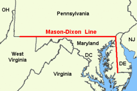

The Mason–Dixon line, also called the Mason and Dixon line or Mason's and Dixon's line, is a demarcation line separating four U.S. states, forming part of the borders of Pennsylvania, Maryland, Delaware, and West Virginia (part of Virginia until 1863). Historically, it came to be seen as demarcating the North from the South in the U.S. It was surveyed between 1763 and 1767 by Charles Mason and Jeremiah Dixon in the resolution of a border dispute involving Maryland, Pennsylvania, and Delaware in Colonial America.[1] The dispute had its origins almost a century earlier in the somewhat confusing proprietary grants by King Charles I to Lord Baltimore (Maryland) and by King Charles II to William Penn (Pennsylvania and Delaware).
The largest, east-west portion of the Mason–Dixon line along the southern Pennsylvania border later became known, informally, as the boundary between the Northern free states and Southern slave states. This usage especially came to prominence during the debate around the Missouri Compromise of 1820, when drawing boundaries between slave and free territory was an issue, and resurfaced during the American Civil War, with border states also coming into play. The Confederate States of America claimed the Virginia portion of the line as part of its northern border, although it never exercised meaningful control that far north especially after West Virginia separated from Virginia and joined the Union as a separate state in 1863. It is still used today in the figurative sense of a line that separates the Northeast and South culturally, politically, and socially (see Dixie).
Background[]

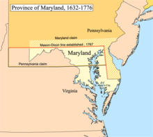
Maryland's charter of 1632 granted Cecil Calvert land north of the entire length of the Potomac River up to the 40th parallel.[2] A problem arose when Charles II granted a charter for Pennsylvania in 1681. The grant defined Pennsylvania's southern border as identical to Maryland's northern border, but described it differently, as Charles relied on an inaccurate map. The terms of the grant clearly indicate that Charles II and William Penn believed the 40th parallel would intersect the Twelve-Mile Circle around New Castle, Delaware, when in fact it falls north of the original boundaries of the City of Philadelphia, the site of which Penn had already selected for his colony's capital city. Negotiations ensued after the problem was discovered in 1681. A compromise proposed by Charles II in 1682, which might have resolved the issue, was undermined by Penn receiving the additional grant of the "Three Lower Counties" along Delaware Bay, which later became the Delaware Colony, a satellite of Pennsylvania. Maryland considered these lands part of its original grant.[3]
The conflict became more of an issue when settlement extended into the interior of the colonies. In 1732 the Proprietary Governor of Maryland, Charles Calvert, 5th Baron Baltimore, signed a provisional agreement with William Penn's sons, which drew a line somewhere in between and renounced the Calvert claim to Delaware. But later, Lord Baltimore claimed that the document he had signed did not contain the terms he had agreed to, and refused to put the agreement into effect. Beginning in the mid-1730s, violence erupted between settlers claiming various loyalties to Maryland and Pennsylvania. The border conflict would be known as Cresap's War.
Progress was made after a Court of Chancery ruling affirming the 1732 agreement, but the issue remained unresolved until Frederick Calvert, 6th Baron Baltimore ceased contesting the claims on the Maryland side and accepted the earlier agreements. Maryland's border with Delaware was to be based on the Transpeninsular Line and the Twelve-Mile Circle around New Castle. The Pennsylvania–Maryland border was defined as the line of latitude 15 miles (24 km) south of the southernmost house in Philadelphia (on what is today South Street). As part of the settlement, the Penns and Calverts commissioned the English team of Charles Mason and Jeremiah Dixon to survey the newly established boundaries between the Province of Pennsylvania, the Province of Maryland, and Delaware Colony.[3]
In 1779, Pennsylvania and Virginia agreed "To extend Mason's and Dixon's line, due west, five degrees of longitude, to be computed from the river Delaware, for the southern boundary of Pennsylvania, and that a meridian, drawn from the western extremity thereof to the northern limit of the said state, be the western boundary of Pennsylvania for ever."[4]
After Pennsylvania abolished slavery in 1781, the western part of this line and the Ohio River became a border between slave and free states, with Delaware[5] retaining slavery until the 13th Amendment was ratified in 1865.
Geography of the line[]

Mason and Dixon's actual survey line began to the south of Philadelphia, Pennsylvania, and extended from a benchmark east to the Delaware River and west to what was then the boundary with western Virginia.
The surveyors also fixed the boundary between Delaware and Pennsylvania and the approximately north–south portion of the boundary between Delaware and Maryland. Most of the Delaware–Pennsylvania boundary is an arc, and the Delaware–Maryland boundary does not run truly north–south because it was intended to bisect the Delmarva Peninsula rather than follow a meridian.[6]
The Maryland–Pennsylvania boundary is an east–west line with an approximate mean latitude of 39°43′20″ N (Datum WGS 84). In reality, the east-west Mason–Dixon line is not a true line in the geometric sense, but is instead a series of many adjoining line segments, following a path between latitude 39°43′15″ N and 39°43′23″ N.
The surveyors also extended the boundary line 40 miles (64 km) west of Maryland's western boundary, into territory that was still in dispute between Pennsylvania and Virginia, though this was contrary to their original charter.[3] Mason and Dixon's survey was finished on October 9, 1767, about 31 miles (50 km) east of what is now Pennsylvania's southwest corner.[7]
In 1774, commissioners from Pennsylvania and Virginia met to negotiate their boundary, which at the time involved Pennsylvania's southern border west of Maryland and its entire western border. Both sides agreed that Pennsylvania's grant made its western border a tracing of the course of the Delaware River, displaced five degrees (approximately 265 miles) to the west. And both sides thought this would place Fort Pitt in Virginia territory (in fact it would not have). With that in mind, the governor of Pennsylvania argued that, despite the agreement reached with Maryland, Pennsylvania's southern border west of Maryland was still the 39th parallel, about 50 miles (80 km) south of the Mason–Dixon line. Negotiations continued for five years, with a series of proposed lines. In the end, a compromise was reached: the Mason–Dixon line would be extended west to a point five degrees west of the Delaware River. To compensate Pennsylvania for the claimed territory lost, its western boundary would be run due north rather than copying the course of the Delaware River.[3]
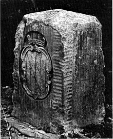
The Mason–Dixon line was marked by stones every mile 1 mile (1.6 km) and "crownstones" every 5 miles (8.0 km), using stone shipped from England. The Maryland side says "(M)" and the Delaware and Pennsylvania sides say "(P)".[citation needed] Crownstones include the two coats of arms. Today, while a number of the original stones are missing or buried, many are still visible, resting on public land and protected by iron cages.[8]
Mason and Dixon confirmed earlier survey work, which delineated Delaware's southern boundary from the Atlantic Ocean to the "Middle Point" stone (along what is today known as the Transpeninsular Line). They proceeded nearly due north from this to the Pennsylvania border.[citation needed]
Later, the line was marked in places by additional benchmarks and survey markers. The lines have been resurveyed several times over the centuries without substantive changes to Mason's and Dixon's work. The stones may be a few, to a few hundred, feet east or west of the point Mason and Dixon thought they were: in any event, the line drawn from stone to stone forms the legal boundary.[citation needed]
History[]
The line was established to end a boundary dispute between the British colonies of Maryland and Pennsylvania/Delaware. Maryland had been granted the territory north of the Potomac River up to the fortieth parallel. Pennsylvania's grant defined the colony's southern boundary as following a 12-mile (radius) circle (19 km) counter-clockwise from the Delaware River until it hit "the beginning of the fortieth degree of Northern latitude." From there the boundary was to follow the fortieth parallel due west for five degrees of longitude. But the fortieth parallel does not, in fact, intersect the 12-mile circle, instead lying significantly farther north. Thus Pennsylvania's southern boundary as defined in its charter was contradictory and unclear. The most serious problem was that the Maryland claim would put Philadelphia, the major city in Pennsylvania, within Maryland.[3]
The dispute was peacefully resolved in 1767[9] when the boundary was fixed as follows:
- Between Pennsylvania and Maryland:
- The parallel (latitude line) 15 miles (24 km) south of the then southernmost point in Philadelphia, measured to be at about 39°43′ N and agreed upon as the Maryland–Pennsylvania line.
- Between Delaware and Maryland:
- The existing east–west transpeninsular line from the Atlantic Ocean to the Chesapeake Bay, as far as its midpoint from the Atlantic.
- A 12-mile (radius) circle (12 mi (19 km)) around the city of New Castle, Delaware.
- A "tangent line" connecting the midpoint of the transpeninsular line to the western side of the 12-mile circle.
- A "north line" along the meridian (line of longitude) from the tangent point to the Maryland-Pennsylvania border.
- Should any land within the 12-mile circle fall west of the north line, it would remain part of Delaware. (This was indeed the case, and this border is the "arc line".)

The disputants engaged an expert British team, astronomer Charles Mason and surveyor Jeremiah Dixon, to survey what became known as the Mason–Dixon line.[10][11] It cost the Calverts of Maryland and the Penns of Pennsylvania £3,512 9/– (equivalent to £455,944 in 2019) to have 244 miles (393 km) surveyed with such accuracy. To them the money was well spent, for in a new country there was no other way of establishing ownership.[12][13]
The Mason–Dixon line is made up of four segments corresponding to the terms of the settlement:
- the tangent line
- the north line
- the arc line
- the 39°43′ N parallel
The most difficult task was fixing the tangent line, as they had to confirm the accuracy of the transpeninsular line midpoint and the 12-mile circle, determine the tangent point along the circle, and then actually survey and monument the border. They then surveyed the north and arc lines. They did this work between 1763 and 1767. This actually left a small wedge of land in dispute between Delaware and Pennsylvania until 1921.[14][better source needed]
In April 1765, Mason and Dixon began their survey of the more famous Maryland–Pennsylvania line. They were commissioned to run it for a distance of five degrees of longitude west from the Delaware River, fixing the western boundary of Pennsylvania (see the entry for Yohogania County). However, in October 1767, at Dunkard Creek near Mount Morris, Pennsylvania, nearly 244 miles (393 km) west of the Delaware, their Iroquois guides refused to go any further, having reached the border of their lands with the Lenape, with whom they were engaged in hostilities. As a result, the group was forced to quit, and on October 11, they made their final observations, 233 miles (375 km) from their starting point.[15]
In 1784, surveyors David Rittenhouse and Andrew Ellicott and their crew completed the survey of the Mason–Dixon line to the southwest corner of Pennsylvania, five degrees from the Delaware River.[note 1] Other surveyors continued west to the Ohio River. The section of the line between the southwestern corner of Pennsylvania and the river is the county line between Marshall and Wetzel counties, West Virginia.[18]
The Mason–Dixon line has been resurveyed three times: in 1849, 1900, and in the 1960s.[10] On November 14, 1963, during the bicentennial of the Mason–Dixon line, U.S. President John F. Kennedy opened a newly completed section of Interstate 95 where it crossed the Maryland–Delaware border. It was one of his last public appearances before his assassination in Dallas, Texas. The Delaware Turnpike and the Maryland portion of the new road were later designated as the John F. Kennedy Memorial Highway.
Systematic errors and experiments to weigh the Earth[]
Mason and Dixon could only do the work as accurately as they did due to the work of Nevil Maskelyne, some of whose instruments they used.[19] There was keen interest in their work and much communication between the surveyors, Maskelyne and other members of the British Scientific establishment in the Royal Society in Britain, notably Henry Cavendish.[20][21][22] During such survey work, it is normal to survey from point to point along the line and then survey back to the starting point, where if there were no errors the origin and re-surveyed position would coincide.[23] Normally the return errors would be random – i.e. the return survey errors compared to the intermediate points back to the start point would be spatially randomly distributed around the start point.[24] Mason and Dixon found that there were larger than expected systematic errors, i.e. non-random errors, that led the return survey consistently being in one direction away from the starting point.[25] When this information got back to the Royal Society members, Henry Cavendish realised that this may have been due to the gravitational pull of the Allegheny Mountains deflecting the theodolite plumb-bobs and spirit levels.[20][26][27] Maskelyne then proposed measuring the gravitational force causing this deflection induced by the pull of a nearby mountain upon a plumb-bob in 1772 and sent Mason (who had returned to Britain) on a site survey through central England and Scotland to find a suitable location during the summer of 1773.[28][29][30] Mason selected Schiehallion at which to conduct what became known as the Schiehallion experiment, which was carried out primarily by Maskelyne and determined the density of the Scottish mountain.[19][29][30] Several years later Cavendish used a very sensitive torsion balance to carry out the Cavendish experiment and determine the average density of Earth.[27]
In culture[]
Name[]
It is unlikely that Mason and Dixon ever heard the phrase "Mason–Dixon line". The official report on the survey, issued in 1768, did not even mention their names.[8] While the term was used occasionally in the decades following the survey, it came into popular use when the Missouri Compromise of 1820 named "Mason and Dixon's line" as part of the boundary between slave territory and free territory.[31]
Symbolism[]
In popular usage to people from the northern United States, the Mason–Dixon line symbolizes a cultural boundary between the North and the South (Dixie). However, for many people who identify as Southern, Maryland is not considered a Southern state,[32] leading to confusion over terminology (for more on Maryland's position as southern or northern, see the Region section of the article on Dixie). Originally "Mason and Dixon's Line" referred to the border between Pennsylvania and Maryland. After Pennsylvania abolished slavery, it served as a demarcation line for the legality of slavery. That demarcation did not extend beyond Pennsylvania because Delaware, then a slave state, extended north and east of the boundary. Also lying north and east of the boundary was New Jersey, where slavery was formally abolished in 1846, but former slaves continued to be "apprenticed" to their masters until the passage of the Thirteenth Amendment to the United States Constitution in 1865.
The Missouri Compromise line (Parallel 36°30′ north) had a much clearer geographic connection to slavery in the United States leading up to the Civil War.[33]
In popular culture[]
This article appears to contain trivial, minor, or unrelated references to popular culture. (June 2020) |
Popular culture contains a multitude of references to the Mason–Dixon line as a general geographic division, or character names evoking it, although a minority of those specifically relate to the line itself.
Film[]
- Mason "The Line" Dixon is a leading character in Rocky Balboa (2006),[34] the sixth film in the Rocky franchise, directed by and starring Sylvester Stallone. Played by real-life boxer Antonio Tarver, Dixon is the current World Heavyweight Boxing Champion who is ridiculed for having never fought a real contender, and who thus agrees to an exhibition fight against the nearly 60-year-old Rocky Balboa.[35]
- In Attack of the Killer Tomatoes (1978), Mason Dixon is the leader of a government task force dedicated to stopping the worldwide crisis when tomatoes turn malignant.[36]
Cartoons[]
- The line makes several appearances[37] in the 1953 Bugs Bunny cartoon "Southern Fried Rabbit". The line separates the drought affected North from which the "Yankee" Bugs leaves in search of carrots in the green lands of the "Dixie" south, the latter being guarded by Yosemite Sam.
Literature[]
- In the novel People's Choice by Jeff Greenfield, the character of W. Dixon Mason is an African-American preacher who plays a major role in determining the next U.S. President when the elected candidate dies between the popular election and the Electoral College formal vote.[38][better source needed]
- Mason & Dixon (1997) is the title of a novel by American author Thomas Pynchon.[39] The novel meanders widely through the lives of Mason and Dixon, traditional American history, and other themes such as hollow earth theory, geomancy, deism, and – perhaps – alien abduction.[40]
Music[]
- The 1918 song, "Rock-a-Bye Your Baby with a Dixie Melody", written by Jean Schwartz, Sam M. Lewis, and Joe Young, popularized by Al Jolson, includes the lyric "Just hang my cradle, Mammy mine/ Right on that Mason–Dixon Line".[41]
- A small group of musicians from Paul Whiteman's orchestra led by C melody saxophonist Frank Trumbauer and including Bix Beiderbecke recorded two sides for Columbia on May 15, 1929 titled, "Alabammy Snow" and "What A Day!" under the pseudonym, "Mason–Dixon Orchestra".[42] It is probable that they chose this pseudonym because the catalog number of the record would be 1861-D, 1861 being the year that the American Civil War began.
- The lyric "First to cross the Mason–Dixon line" featured in the opening verse of the song "I've Done it Again" (composers Marianne Faithfull / Barry Reynolds) on Grace Jones' 1981 album Nightclubbing.[43]
- The 1955 song, "Hey, Porter", by Johnny Cash makes reference to the Mason–Dixon line in the line, How much longer will it be until we cross that Mason-Dixon line?[44]
- From the 2000 album "Sailing to Philadelphia" by British singer-songwriter and guitarist Mark Knopfler, the title track (also featuring James Taylor) is about the two English surveyors Charles Mason and Jeremiah Dixon travelling to Philadelphia to survey the Mason–Dixon line; the lyrics draw from Mason & Dixon by Thomas Pynchon, a novel about their relationship.[45]
- Sonic Youth Paper Cup Exit from Sonic Nurse (2004) has the line "Touch down on the new Mason-Dixon line" (sang by Lee Ranaldo)
- Dan Seals sung "Mason Dixon line" and the song symbolically references the line.[46]
- GZA references the "Mason-Dixon Line" in the closing words of his feature verse on Raekwon's song "Guillotine (Swords)" from his debut 1995 album Only Built 4 Cuban Linx.[47]
- Tom Lehrer references the Mason–Dixon line in his song "I Wanna Go Back to Dixie".[48]
- The song "Home is where the heart is" on Lady Antebellum's eponymous album contains the line "It's just south of the Mason-Dixon line".[49]
- The 1916 song "Are You from Dixie ('Cause I'm from Dixie Too)" originally recorded by Billy Murray contains the lyrics "If you're from Alabama, Tennessee, or Caroline. Any place below the Mason-Dixon line. Then you're from Dixie."[50]
- Brad Paisley, LL Cool J, and Lee Thomas Miller's controversial 2013 song "Accidental Racist" uses the Mason–Dixon line as a metaphor for north–south, black/white, and other cultural (dysfunctional) relations: "Oh, Dixieland/The relationship between the Mason-Dixon needs some fixin'"[51]
- Country trio Dixie Chicks announced on June 25, 2020 that they would drop the "Dixie" from their name due to its racial significance, renaming the band to "The Chicks" in the wake of George Floyd's wider national reckoning of all racially charged signifiers.[52]
- David Allan Coe sings about the Mason Dixon line in 'I still Sing the old songs'
- Connie Smith sings about the Mason Dixon Line in 'Cincinnati, Ohio', lyrics by Bill Anderson
Sports[]
- In the regional baseball rivalry between the New York Yankees and the Boston Red Sox, the theoretical border that separates population centers that are majority-Red Sox fans from majority-Yankees fans in Connecticut is sometimes called the "Munson-Nixon Line",[53][54][55] in a reference to the Mason–Dixon line. Credited to Steve Rushin of Sports Illustrated,[53] the line is named for famed Yankee catcher Thurman Munson and Red Sox right fielder Trot Nixon. In the book The Nine Nations of North America, this line is mentioned (but not named) as the true marker of whether a given location in Connecticut is socially part of New England or the rust belt region the author calls The Foundry.[56] This line has moved over the years, but it's still there.
See also[]
- Collins–Valentine line, the boundary between the province of Quebec and the states of New York and Vermont
- Delaware Boundary Markers
- Penn–Calvert boundary dispute
- Mason and Dixon Survey Terminal Point
- Star Gazers' Stone
- Tofu Curtain
- Weißwurstäquator, a similar border line in Germany between the Northern and Southern areas of the country.
Notes[]
- ^ Four surveyors were appointed by each of the states: Virginia appointed Dr. James Madison, Robert Andrews, John Page, and Andrew Ellicott, Pennsylvania appointed Dr. John Ewing (provost of University of Penn.), (surveyor general of Penn.), Thomas Hutchins, and David Rittenhouse. Andrews and Ellicott completed the west end of the line for Virginia,[16] while Hutchins and Ewing did so for Pennsylvania.[17]
References[]
- ^ Sally M. Walker (2014). Boundaries: How the Mason-Dixon Line Settled a Family Feud and Divided a Nation. Candlewick Press. ISBN 9780763670368.
- ^ "Maryland Geological Survey, Volume 7" (PDF). Maryland State Archives. Retrieved March 20, 2015. See section "History of the Boundary Dispute Between the Baltimores and Penns Resulting in the Original Mason and Dixon Line" by Edward Bennett Matthews
- ^ Jump up to: a b c d e Hubbard, Bill, Jr. (2009). American Boundaries: the Nation, the States, the Rectangular Survey. University of Chicago Press. pp. 20–29. ISBN 978-0-226-35591-7.
- ^ Barton, William (1818). Memoirs of the life of David Rittenhouse, LLD. F.R.S. E. Parker. pp. 282–283. ISBN 9780608436135.
- ^ "Slavery in Delaware". Slavery in the North. Retrieved October 6, 2015.
- ^ Danson, Edwin (2001). Drawing the Line How Mason and Dixon Surveyed the Most Famous Border in America. John Wiley. p. 54.
- ^ Wilford, John Noble (2001). The Mapmakers: Revised Edition. Random House Digital, Inc. pp. 215–216. ISBN 978-0-375-70850-3. Retrieved November 1, 2012.
- ^ Jump up to: a b William Ecenbarger, "Neglecting the Mason–Dixon boundary stones", The Washington Post, January 1, 2017, p. C4.
- ^ Konkle, Burton Alva. (1932). Benjamin Chew 1722–1810: Head of the Pennsylvania judiciary system under colony and commonwealth. Philadelphia: University of Pennsylvania Press. p. 63-4.
- ^ Jump up to: a b "A Plan of the West Line or Parallel of Latitude". World Digital Library. 1768. Retrieved June 30, 2013.
- ^ "The men who drew the Mason–Dixon Line". BBC. September 2, 2017. Retrieved September 2, 2017.
- ^ Linklater, Andro (September 30, 2003). Measuring America. Penguin. p. 33. ISBN 978-0-452-28459-3.
- ^ Mason, A. Hughlett; Swindler, William F. (February 1964). "Mason & Dixon: their Line and its Legend". American Heritage. 15 (2). Archived from the original on December 5, 2008. Retrieved November 8, 2008.
- ^ U.S. Coast And Geodetic Survey (1895). "Annual Report of the Director". U.S. Coast and Geodetic Survey: 195. Retrieved December 20, 2012.
- ^ Danson, Edwin (2001). Drawing the Line: How Mason and Dixon Surveyed the Most Famous Border in America. John Wiley and Sons. pp. 178–79. ISBN 9780471437048.
- ^ Mathews, Catherine Van Courtlandt (1908). Andrew Ellicott, His Life and Letters. New York: The Grafton Press. pp. 17–19.
- ^ Hicks, Fredrick (1904). "Biographical Sketch of Thomas Hutchins". In Hicks, Fredrick (ed.). A Topographical Description of Virginia, Pennsylvania, Maryland and North Carolina, reprinted from the original edition of 1778. Cleveland: The Burrow Brothers Company. p. 32.
- ^ Strang, Cameron (2014). "Mason–Dixon Line". The Encyclopedia of Greater Philadelphia. Rutgers University. Retrieved October 26, 2019.
- ^ Jump up to: a b Davies, R.D (1985). "A Commemoration of Maskelyne at Schiehallion". Quarterly Journal of the Royal Astronomical Society. 26 (3): 289–294. Bibcode:1985QJRAS..26..289D.
- ^ Jump up to: a b Note the comments on Cavendish's speculation in the introductory notes, and the multiple correspondences with Maskelyne in: Mason, Charles; Dixon, Jeremiah. "The Journal of Charles Mason and Jeremiah Dixon 1763–1768" (PDF). Retrieved January 5, 2011.
- ^ Nevil Maskelyne was elected a Royal Society Fellow on April 27, 1758; see "List of Fellows of the Royal Society 1660–2007". Royal Society. 2007. p. 238. Archived from the original (pdf) on November 30, 2010. Retrieved January 5, 2011.
- ^ Henry Cavendish was elected a Royal Society Fellow on May 1, 1760; see "List of Fellows of the Royal Society 1660–2007". Royal Society. 2007. p. 66. Archived from the original (pdf) on November 30, 2010. Retrieved January 5, 2011.
- ^ "Specifications and Recommendations for Control Surveys and Survey Markers". Natural Resources Canada. December 27, 2007. p. TABLE E-VI POSITION DIFFERENCES. Archived from the original on May 26, 2011. Retrieved January 6, 2011.
Double run in straight line by helicopter between control spaced at 80 km.
- ^ Taylor, John Robert (1999). An Introduction to Error Analysis: The Study of Uncertainties in Physical Measurements. University Science Books. p. 94, §4.1. ISBN 0-935702-75-X. Retrieved January 5, 2011.
- ^ Mentzer, Robert. "How Mason and Dixon Ran Their Line" (PDF). Retrieved December 1, 2019.
- ^ Schaffer, Simon (May 20, 2010). "The Cavendish Family in Science". BBC Radio 4 (Interview).
- ^ Jump up to: a b Tretkoff, Ernie. "This Month in Physics History June 1798: Cavendish weighs the world". American Physical Society. Retrieved January 3, 2011.
- ^ Maskelyne, Nevil (January 1, 1775). "An account of observations made on the mountain Schehallien for finding its attraction". Philosophical Transactions of the Royal Society of London. London. 65: 500–542. doi:10.1098/rstl.1775.0050.
Accordingly Mr. Charles Mason, who had been employed on several astronomical occasions by the Royal Society, was appointed to make a tour through the Highlands of Scotland in the summer of the year 1773, taking notice of the principal hills in England which lay in his route either in his going or in his return.
- ^ Jump up to: a b Sillitto, Richard M. (October 31, 1990). "Maskelyne on Schiehallion". The Royal Philosophical Society of Glasgow. Retrieved January 3, 2011.
The Royal Society agreed to a proposal that it despatch a surveyor, a Mr Charles Mason whom they had previously employed on astronomical projects, all the way to Scotland and back, to survey likely-looking mountains, and to select a suitable mountain – ideally it should be a steep-sided cone, or a wedge with its apex ridge running W – E and with steep faces to N and S, and separated from the nearest neighbours to N and S by low land. Mr Mason selected for them a mountain at "the centre of Scotland", Schiehallion – a wedge, with the summit ridge running nearly W – E, 3547 ft above sea level at its western summit, about 3000 ft at the E-end of the ridge; it presents steep faces to the trench to the N which contains Loch Rannoch and Loch Tummel, and to the deep Gleann Mor to the S. [An approximate altitude for Gleann Mor is 1500 feet, and for the land at the same distance to the north of the ridge is 1600 ft.]
- ^ Jump up to: a b Mackenzie, A. Stanley (1900). "Account of Maskelyne's experiments on Schehallien". The Laws of Gravitation: Memoirs by Newton, Bouguer and Cavendish; together with abstracts of other important memoirs. New York: American Book Company. p. 53. Retrieved January 3, 2011.
In 1772...The proposal was favourably received by the Society, and Mr. Charles Mason was sent to examine various hills in England and Scotland, and to select the most suitable (32). Mason found the two hills referred to by Maskelyne were not suitable; and fixed upon Schehallien in Perthshire as offering the best situation.
- ^ John Mackenzie, "A brief history of the Mason–Dixon Line Archived July 17, 2018, at the Wayback Machine", APEC/CANR, University of Delaware; accessed 2017.01.05.
- ^ Rasmussen, Frederick (March 28, 2010). "Are we Northern? Southern? Yes". The Baltimore Sun. Retrieved February 23, 2018.
- ^ "An Act to provide a temporary Government for the Territory of Colorado" (PDF). Thirty-sixth United States Congress. February 28, 1861. Retrieved February 22, 2007.
- ^ "Rocky Balboa". The Internet Movie Database. 2006.
- ^ "Film Review". Empire Magazine. 2007.
- ^ Dean, Sam. "Attack of the Killer Tomatoes: An Oral History of the 1978 Film".
- ^ "still from the cartoon "southern fried rabbit" showing the line". yosemite-sam.net/. 2017.
- ^ "Fiction Book Review: People's Choice by Jeff Greenfield, Author Putnam Publishing Group $22.95 (309p) ISBN 978-0-399-13812-6".
- ^ "Book review – Mason & Dixon". The New York Times. 1997.
- ^ "Mason & Dixon". ThomasPynchon.com.
- ^ Sheet music (copyright 1918) viewable at https://levysheetmusic.mse.jhu.edu/collection/154/093
- ^ Discography of American Historical Recordings, s.v. "Columbia 1861-D (10-in. double-faced)," accessed August 30, 2017, http://adp.library.ucsb.edu/index.php/object/detail/196765/Columbia_1861-D.
- ^ "Grace Jones – I've Done It Again" – via genius.com.
- ^ Lyrics of this song at MetroLyrics
- ^ "Sailing to Philadelphia". Retrieved August 16, 2019.
- ^ "Mason Dixon Line". Retrieved October 24, 2019.
- ^ Raekwon (Ft. Ghostface Killah, GZA & Inspectah Deck) – Guillotine (Swordz), retrieved May 23, 2019
- ^ "I Wanna Go Back to Dixie". Retrieved October 24, 2019.
- ^ "Lady Antebellum "Home Is Where The Heart Is" Lyrics". Archived from the original on March 18, 2020. Retrieved March 17, 2020.
- ^ Yellen, Jack; Cobb, George (January 1, 1915). "Are You from Dixie? ('Cause I'm from Dixie Too)". Historic Sheet Music Collection.
- ^ "Brad Paisley's 'Accidental Racist': LL Cool J's 10 Craziest Lyrics". Billboard. April 8, 2013. Retrieved April 14, 2021.
- ^ Beaumont-Thomas, Ben (June 25, 2020). "Dixie Chicks change name to the Chicks due to slavery-era connotations". The Guardian. ISSN 0261-3077. Retrieved June 25, 2020.
- ^ Jump up to: a b Giratikanon, Tom; Katz, Josh; Leonhardt, David; Quealy, Kevin (April 24, 2014). "Up Close on Baseball's Borders". The New York Times. ISSN 0362-4331. Retrieved October 25, 2017.
- ^ RUSHIN, STEVE. "Reconcilable Differences". SI.com. Retrieved October 25, 2017.
- ^ "Baseball's Borders". The American Spectator. April 25, 2014. Retrieved October 25, 2017.
- ^ Joel Garreau (1981). The Nine Nations of North America. Houghton Mifflin. p. 17. ISBN 0-395-29124-0.
Further reading[]
- Danson, Edwin. Drawing the Line: How Mason and Dixon Surveyed the Most Famous Border in America. Wiley. ISBN 0-471-38502-6.
- Ecenbarger, Bill. Walkin' the Line: A Journey from Past to Present Along the Mason–Dixon. M. Evans. ISBN 978-0-87131-962-3.
External links[]
| Wikimedia Commons has media related to Mason-Dixon Line. |
| Wikisource has the text of the 1879 American Cyclopædia article Mason and Dixon's Line. |
- The Mason and Dixon Line Preservation Partnership Collection of historical articles and pictures
- The Evolution of the Mason and Dixon Line Facsimile copy of this 1902 text available on-line at Penn State's Digital Bookshelf
- . New International Encyclopedia. 1905.
- . Encyclopædia Britannica (11th ed.). 1911.
- . . 1914.
- Mason and Dixon in Mill Creek, Friends of White Clay Creek State Park
- University of North Carolina: Southern Things[permanent dead link]
- The history of Mason and Dixon's line; The Historical Society of Pennsylvania (1855)
Coordinates: 39°43′N 75°47′W / 39.717°N 75.783°W
| hide Authority control | |
|---|---|
| General | |
| National libraries | |
| Other | |
- Mason–Dixon line
- 1767 establishments in the Thirteen Colonies
- 1767 in international relations
- Cultural boundaries
- Borders of Delaware
- Borders of Maryland
- Borders of Pennsylvania
- Borders of West Virginia
- Delaware in the American Civil War
- Geographic history of the United States
- Historic Civil Engineering Landmarks
- History of the Southern United States
- History of the Northeastern United States
- History of United States expansionism
- Surveying of the United States
- Circles of latitude
- Maryland in the American Civil War
- Pennsylvania in the American Civil War
- Pre-statehood history of Maryland
- Pre-statehood history of Pennsylvania
- Pre-statehood history of Virginia
- Pre-statehood history of West Virginia
- Slavery in the United States
- Borders of U.S. states
- Meridians (geography)
- Eponymous border lines
- Northeastern United States