Smithfield, Pennsylvania
Smithfield, Pennsylvania | |
|---|---|
 | |
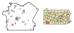 Location of Smithfield in Fayette County, Pennsylvania. | |
 Smithfield Location in Pennsylvania | |
| Coordinates: 39°47′59″N 79°48′30″W / 39.79972°N 79.80833°WCoordinates: 39°47′59″N 79°48′30″W / 39.79972°N 79.80833°W | |
| Country | United States |
| State | Pennsylvania |
| County | Fayette |
| Established | 1799 |
| Government | |
| • Mayor | Chuck Cyzenski |
| Area | |
| • Total | 0.71 sq mi (1.85 km2) |
| • Land | 0.71 sq mi (1.85 km2) |
| • Water | 0.00 sq mi (0.00 km2) |
| Elevation | 1,089 ft (332 m) |
| Population (2010) | |
| • Total | 875 |
| • Estimate (2019)[2] | 826 |
| • Density | 1,155.24/sq mi (445.84/km2) |
| Time zone | UTC-4 (EST) |
| • Summer (DST) | UTC-5 (EDT) |
| ZIP code | 15478 |
| Area code(s) | 724 |


Smithfield is a borough in Fayette County, Pennsylvania, United States. The population was 875 at the 2010 census.[3] It is served by the Albert Gallatin Area School District. The town's largest employer is a small wire producing plant run by Nelson Steel.
Geography[]
Smithfield is located in southwestern Fayette County at 39°47′59″N 79°48′30″W / 39.79972°N 79.80833°W (39.799664, -79.808197).[4] According to the United States Census Bureau, the borough has a total area of 0.71 square miles (1.84 km2), all of it land.[3]
U.S. Route 119 passes through the center of the borough, leading northeast 9 miles (14 km) to Uniontown, the county seat, and southwest 8 miles (13 km) to Point Marion.
Demographics[]
| Historical population | |||
|---|---|---|---|
| Census | Pop. | %± | |
| 1900 | 525 | — | |
| 1910 | 749 | 42.7% | |
| 1920 | 940 | 25.5% | |
| 1930 | 949 | 1.0% | |
| 1940 | 996 | 5.0% | |
| 1950 | 1,066 | 7.0% | |
| 1960 | 939 | −11.9% | |
| 1970 | 969 | 3.2% | |
| 1980 | 1,084 | 11.9% | |
| 1990 | 1,000 | −7.7% | |
| 2000 | 854 | −14.6% | |
| 2010 | 875 | 2.5% | |
| 2020 (est.) | 831 | [2] | −5.0% |
| Sources:[5][6][7] | |||
As of the census[6] of 2000, there were 854 people, 363 households, and 234 families residing in the borough. The population density was 1,196.5 people per square mile (464.4/km2). There were 384 housing units at an average density of 538.0 per square mile (208.8/km2). The racial makeup of the borough was 99.65% White, 0.23% African American and 0.12% Pacific Islander.
There were 363 households, out of which 26.2% had children under the age of 18 living with them, 52.3% were married couples living together, 10.7% had a female householder with no husband present, and 35.5% were non-families. 32.8% of all households were made up of individuals, and 17.6% had someone living alone who was 65 years of age or older. The average household size was 2.33 and the average family size was 2.99.
In the borough the population was spread out, with 21.4% under the age of 18, 7.0% from 18 to 24, 27.6% from 25 to 44, 23.9% from 45 to 64, and 20.0% who were 65 years of age or older. The median age was 42 years. For every 100 females, there were 86.5 males. For every 100 females age 18 and over, there were 78.9 males.
The median income for a household in the borough was $26,667, and the median income for a family was $35,714. Males had a median income of $25,000 versus $17,404 for females. The per capita income for the borough was $13,618. About 11.7% of families and 14.3% of the population were below the poverty line, including 27.9% of those under age 18 and 9.5% of those age 65 or over.
References[]
- ^ "2019 U.S. Gazetteer Files". United States Census Bureau. Retrieved July 28, 2020.
- ^ a b "Population and Housing Unit Estimates". United States Census Bureau. May 24, 2020. Retrieved May 27, 2020.
- ^ a b "Geographic Identifiers: 2010 Census Summary File 1 (G001), Smithfield borough, Pennsylvania". American FactFinder. U.S. Census Bureau. Archived from the original on February 13, 2020. Retrieved July 8, 2016.
- ^ "US Gazetteer files: 2010, 2000, and 1990". United States Census Bureau. 2011-02-12. Retrieved 2011-04-23.
- ^ "Census of Population and Housing". U.S. Census Bureau. Retrieved 11 December 2013.
- ^ a b "U.S. Census website". United States Census Bureau. Retrieved 2008-01-31.
- ^ "Incorporated Places and Minor Civil Divisions Datasets: Subcounty Resident Population Estimates: April 1, 2010 to July 1, 2012". Population Estimates. U.S. Census Bureau. Archived from the original on 11 June 2013. Retrieved 11 December 2013.
External links[]
| Wikimedia Commons has media related to Smithfield, Pennsylvania. |
| Counties |  Map of the Pittsburgh Tri-State with green counties in the metropolitan area and yellow counties in the combined area | |
|---|---|---|
| Major cities | ||
| Cities and towns 15k–50k (in 2010) | ||
| Airports | ||
| Topics |
| |
| ||
Municipalities and communities of Fayette County, Pennsylvania, United States | ||
|---|---|---|
| Cities |  | |
| Boroughs | ||
| Townships | ||
| CDPs | ||
| Unincorporated communities |
| |
| Footnotes | ‡This populated place also has portions in an adjacent county or counties | |
| ||
- Populated places established in 1799
- Pittsburgh metropolitan area
- Boroughs in Fayette County, Pennsylvania
- 1799 establishments in Pennsylvania