Adams County, Pennsylvania
Adams County | |
|---|---|
U.S. county | |
 | |
 Seal | |
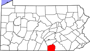 Location within the U.S. state of Pennsylvania | |
 Pennsylvania's location within the U.S. | |
| Coordinates: 39°52′N 77°13′W / 39.87°N 77.22°W | |
| Country | |
| State | |
| Founded | January 22, 1800 |
| Named for | John Adams |
| Seat | Gettysburg |
| Largest borough | Gettysburg |
| Area | |
| • Total | 522 sq mi (1,350 km2) |
| • Land | 519 sq mi (1,340 km2) |
| • Water | 3.1 sq mi (8 km2) 0.6%% |
| Population | |
| • Estimate (2018) | 102,811 |
| • Density | 197/sq mi (76/km2) |
| Time zone | UTC−5 (Eastern) |
| • Summer (DST) | UTC−4 (EDT) |
| Congressional district | 13th |
| Website | www |
| Type | City |
| Designated | November 6, 1982[1] |

Adams County is a county in the U.S. state of Pennsylvania. As of the 2010 census, the population was 101,407.[2] Its county seat is Gettysburg.[3] The county was created on January 22, 1800, from part of York County, and was named for the second President of the United States, John Adams. On July 1–3, 1863, the area around Gettysburg was the site of the pivotal battle of the American Civil War, and as a result is a center for Civil War tourism.
Adams County comprises the Gettysburg, PA Metropolitan Statistical Area, which is also included in the Harrisburg-York-Lebanon, PA Combined Statistical Area.
Geography[]

According to the U.S. Census Bureau, the county has a total area of 522 square miles (1,350 km2), of which 519 square miles (1,340 km2) is land and 3.1 square miles (8.0 km2) (0.6%) is water.[4] The Borough of Gettysburg is located at the center of Adams County. This county seat community is surrounded on three sides by the Gettysburg National Military Park (GNMP). The Eisenhower National Historic Site adjoins GNMP on its southwest edge. Most of Adams County's rural landscapes and its mid-19th century roadway pattern remain intact today. Thirteen historic roadways converge at or near Gettysburg Borough. Two circular rings of towns surround Gettysburg; the first is typically found at a distance of about 7 miles (11 km) from Gettysburg. The second ring is found at a distance of 12 to 15 miles (24 km) from the County Seat. This "spokes and wheel" pattern is one of the few examples of Central Place Theory in the Eastern United States.
The county is in the watershed of the Chesapeake Bay and is drained by the Susquehanna and Potomac Rivers.
Adjacent counties[]
- Cumberland County (north)
- York County (east)
- Carroll County, Maryland (southeast)
- Frederick County, Maryland (southwest)
- Franklin County (west)
National protected areas[]
- Eisenhower National Historic Site
- Gettysburg National Military Park
Climate[]
Adams has a hot-summer humid continental climate (Dfa).
| hideClimate data for Gettysburg, Pennsylvania | |||||||||||||
|---|---|---|---|---|---|---|---|---|---|---|---|---|---|
| Month | Jan | Feb | Mar | Apr | May | Jun | Jul | Aug | Sep | Oct | Nov | Dec | Year |
| Record high °F (°C) | 72 (22) |
78 (26) |
87 (31) |
93 (34) |
93 (34) |
98 (37) |
104 (40) |
104 (40) |
98 (37) |
92 (33) |
83 (28) |
79 (26) |
104 (40) |
| Average high °F (°C) | 39 (4) |
43 (6) |
52 (11) |
64 (18) |
73 (23) |
82 (28) |
86 (30) |
84 (29) |
77 (25) |
66 (19) |
55 (13) |
43 (6) |
64 (18) |
| Average low °F (°C) | 21 (−6) |
23 (−5) |
30 (−1) |
40 (4) |
49 (9) |
58 (14) |
63 (17) |
61 (16) |
53 (12) |
41 (5) |
33 (1) |
25 (−4) |
41 (5) |
| Record low °F (°C) | −25 (−32) |
−14 (−26) |
0 (−18) |
16 (−9) |
27 (−3) |
35 (2) |
43 (6) |
35 (2) |
31 (−1) |
20 (−7) |
12 (−11) |
−5 (−21) |
−25 (−32) |
| Average precipitation inches (mm) | 3.24 (82) |
3.00 (76) |
3.54 (90) |
3.53 (90) |
4.33 (110) |
4.29 (109) |
3.36 (85) |
3.81 (97) |
4.22 (107) |
3.28 (83) |
3.40 (86) |
3.23 (82) |
43.23 (1,097) |
| Source: The Weather Channel[5] | |||||||||||||
Government[]
Commissioners[]
Adams County is administered by a three-person Board of Commissioners, who serve four-year terms. Elections occur in the odd-numbered years that precede U.S. Presidential elections, with the next election falling in 2023. All three Commissioners are chosen in the same election, and voters may vote for no more than two of the candidates. The Commissioners are responsible for the management of the fiscal and administrative functions of the county.
| Official | Party | Term ends |
|---|---|---|
| Randy Phiel | Republican | 2023 |
| Jim Martin | Republican | 2023 |
| Marty Qually | Democratic | 2023 |
Elected County Officials[]
As of the November 2017 election:[6]
| Office | Official | Party | Term ends |
|---|---|---|---|
| Clerk of Courts | Kelly A. Lawver | Republican | 2023 |
| Controller | John Phillips | Republican | 2023 |
| Coroner | Patricia Felix | Republican | 2023 |
| Treasurer | Chrissy Redding | Republican | 2021 |
| District Attorney | Brian Sinnett | Republican | 2023 |
| Prothonotary | Beverly Boyd | Republican | 2023 |
| Recorder of Deeds and Register of Wills | Karen Heflin | Republican | 2023 |
| Sheriff | James W. Muller | Republican | 2021 |
Politics[]
Presidential politics
Adams is a consistently Republican County. In 2020, Donald Trump carried the county with 66.3% of the vote to Joe Biden's 32.2%. In 2016, Democratic nominee Hillary Clinton only received 29.6% of the vote, the lowest share any Democrat had received in the county since George McGovern 44 years prior.[7] No Democratic presidential candidate has won Adams County since Lyndon Johnson’s 1964 landslide.[8] This said, the city of Gettysburg is reliably Democratic as of 2020, with Democratic nominee Biden carrying it 63%-35%.[9]
Pennsylvania House of Representatives[]
Adams County consists of two Pennsylvania House Districts. The 91st district is exclusively in Adams County, comprising the southern and middle parts of the county, including Gettysburg. The 193rd District spans into Cumberland County to the north.
| District | Representative | Party |
|---|---|---|
| 91 | Dan Moul | Republican |
| 193 | Torren Ecker | Republican |
Pennsylvania Senate[]
Adams County is entirely contained within the 33rd Senatorial District, which also includes parts of York and Franklin Counties.
| District | Representative | Party |
|---|---|---|
| 33 | Doug Mastriano | Republican |
United States House of Representatives[]
From 2012 until 2018, Adams County was part of the 4th Congressional District until the Pennsylvania Supreme Court ruled that the Commonwealth's Congressional Districts constituted an illegal partisan Gerrymander.[12] As a result, Adams County was moved from the 4th District to the 13th Congressional District and elected a new Representative in the 2018 election.
| District | Representative | Party |
|---|---|---|
| 13 | John Joyce | Republican |
United States Senate[]
- Pat Toomey, Republican
- Bob Casey Jr., Democratic
Voter Registration[]
As of November 16, 2020 there were 72,357 registered voters in the county. Republicans hold a majority of the voters. There was 40,767 registered Republicans, 20,051 registered Democrats, 8,078 voters without any partisan affiliation, and 3,461 voters registered to other parties. "Other Parties" also includes voters who left their preferred party blank; only those who chose No Affiliation are included under No Partisan Affiliation.[13]
Chart of Voter Registration
| Voter registration and party enrollment | |||||
|---|---|---|---|---|---|
| Party | Number of voters | Percentage | |||
| Republican | 40,767 | 56.34 | |||
| Democratic | 20,051 | 27.71 | |||
| No Partisan Affiliation | 8,078 | 11.16 | |||
| Other Parties | 3,461 | 4.16 | |||
| Total | 72,357 | 100% | |||
Demographics[]
| Historical population | |||
|---|---|---|---|
| Census | Pop. | %± | |
| 1800 | 13,172 | — | |
| 1810 | 15,152 | 15.0% | |
| 1820 | 19,370 | 27.8% | |
| 1830 | 21,379 | 10.4% | |
| 1840 | 23,044 | 7.8% | |
| 1850 | 25,981 | 12.7% | |
| 1860 | 28,006 | 7.8% | |
| 1870 | 30,315 | 8.2% | |
| 1880 | 32,455 | 7.1% | |
| 1890 | 33,486 | 3.2% | |
| 1900 | 34,496 | 3.0% | |
| 1910 | 34,319 | −0.5% | |
| 1920 | 34,583 | 0.8% | |
| 1930 | 37,128 | 7.4% | |
| 1940 | 39,435 | 6.2% | |
| 1950 | 44,197 | 12.1% | |
| 1960 | 51,906 | 17.4% | |
| 1970 | 56,937 | 9.7% | |
| 1980 | 68,292 | 19.9% | |
| 1990 | 78,274 | 14.6% | |
| 2000 | 91,292 | 16.6% | |
| 2010 | 101,407 | 11.1% | |
| 2018 (est.) | 102,811 | [14] | 1.4% |
| U.S. Decennial Census[15] 1790–1960[16] 1900–1990[17] 1990–2000[18] 2010–2017[2] | |||
As of the 2010 census,[19] there were 101,407 people, 33,652 households, and 24,767 families in the county. The population density was 194 people per square mile (75/km2). There were 35,831 housing units at an average density of 69 per square mile (27/km2). The racial makeup of the county was 95.39% White, 1.21% Black or African American, 0.20% Native American, 0.49% Asian, 0.02% Pacific Islander, 1.71% from other races, and 0.97% from two or more races. 3.64% of the population were Hispanic or Latino of any race. 42.7% were of German, 14.1% American, 8.5% Irish and 7.1% English ancestry. 95.0% spoke English and 3.6% Spanish as their first language.
There were 33,652 households, of which 33.70% had children under the age of 18 living with them, 61.10% were married couples living together, 8.50% had a female householder with no husband present, and 26.40% were non-families. 21.30% of all households were made up of individuals, and 9.20% had someone living alone who was 65 years of age or older. The average household size was 2.61 and the average family size was 3.02.
The county population was spread out, with 24.90% under the age of 18, 9.20% from 18 to 24, 28.90% from 25 to 44, 23.00% from 45 to 64, and 13.90% who were 65 years of age or older. The median age was 37 years. For every 100 females there were 96.30 males. For every 100 females age 18 and over, there were 93.80 males. Adams County is one of two counties in Pennsylvania where Latter-Day Saints make up 1% of the population.
- Birth rate
Per the Pennsylvania Department of Health, Adams County's live birth rate was 1,132 births in 1990. The County's live birth rate in 2000 was 1,048 births, while in 2011 it had declined to 1,039 babies.[20] Over the past 50 years (1960 to 2010), rural Pennsylvania saw a steady decline in both the number and proportion of residents under 18 years old. In 1960, 1.06 million rural residents, or 35 percent of the rural population, were children.
- Teen pregnancy rate
Adams County had 29 babies born to teens (age15-19) in 2011. In 2014, the number of teen births in Adams County was 27.[21]
- County poverty demographics
According to research by , a legislative Agency of the Pennsylvania General Assembly, the poverty rate for Adams County was 10.8% in 2014.[22] The statewide poverty rate was 13.6% in 2014. The 2012 childhood poverty rate by school district was: Bermudian Springs School District – 32.4% living at 185% or below than the Federal Poverty Level, Conewago Valley School District – 37.3%, Fairfield Area School District – 19.5%, Gettysburg Area School District – 42.3%, Littlestown Area School District – 32.1%, and Upper Adams School District – 45.5%.[23]
Metropolitan and Combined Statistical Area[]
The US OMB[24] has designated Adams County as the Gettysburg, PA Metropolitan Statistical Area (MSA). As of the 2010 census[25] the metropolitan area population of 101,407 ranked 19th most populous in the State of Pennsylvania and the 349th most populous in the United States. Adams County is also a part of the larger Harrisburg-York-Lebanon, PA Combined Statistical Area (CSA), which combines the populations of Adams County with those of Cumberland, Dauphin, Lebanon, Perry and York Counties in Pennsylvania. The Combined Statistical Area ranked 5th in the State of Pennsylvania and 43rd most populous in the United States with a population of 1,219,422.
Education[]

Colleges and universities[]
- Gettysburg College
- Lutheran Theological Seminary
Community, junior and technical colleges[]
- Harrisburg Area Community College
Public school districts[]
- Bermudian Springs School District – ranked 252nd (2016),[26] 350th (2012), 289th (2008)
- Conewago Valley School District – ranked 160th (2016), 310th (2012), 330th (2008)
- Fairfield Area School District – ranked 232nd (2016), 332nd (2012), 410th (2008)
- Gettysburg Area School District – ranked 95th (2016), 180th (2012), 318th (2008)
- Littlestown Area School District – ranked 143rd (2016), 293rd (2012), 280th (2008)
- Upper Adams School District – ranked 269th (2016), 272nd (2012), 274th (2008)
The 496 school districts of Pennsylvania that operate high schools were ranked for student academic achievement, as demonstrated by three years of math, reading, writing and science PSSA results.[27][28]
Public charter schools[]
- Gettysburg Montessori Charter School – Gettysburg (K-6)
- Vida Charter School – Gettysburg (K-6)
County residents may apply to attend any of the Commonwealth's 14 (as of 2015) public, cyber charter schools at no additional cost to the parents.[29]
Private schools[]
As reported by Pennsylvania Department of Education April 2015
- Academy for Media Production – McSherrystown
- Adams County Christian Academy – Gettysburg
- Delone Catholic High School – McSherrystown
- Forest Lane Mennonite School – Gettysburg
- Freedom Christian School – Gettysburg
- Gettysburg SDA Church School – Gettysburg
- Independent Baptist Day School – Biglerville
- JIL Christian School – Biglerville
- Littlestown Christian Academy – Littlestown
- Oxford Christian Academy – New Oxford
- Paradise School – Abbottstown
- St. Teresa of Calcutta School -McSherrystown
- St James Child Care Center – Gettysburg
- St Joseph Academy Preschool – McSherrystown
Intermediate Unit[]
Lincoln Intermediate Unit (IU#12) region includes: Adams, Franklin, and York Counties. The agency offers school districts, home schooled students and private schools many services including: Special education services, combined purchasing, and instructional technology services. It runs Summer Academy which offers both art and academic strands designed to meet the needs of gifted, talented and high achieving students. Additional services include: Curriculum Mapping, Professional Development for school employees, Adult Education, Nonpublic School Services, Business Services, Migrant & ESL (English as a Second Language), Instructional Services, Special Education, Management Services, and Technology Services. It provides a GED program for adults to earn a high school diploma, and offers literacy programs. The Lincoln Intermediate Unit is governed by a 13-member Board of Directors, each a member of a local school board from the 25 school districts. Board members are elected by school directors of all 25 school districts for three-year terms that begin July 1.[30] There are 29 intermediate units in Pennsylvania. They are funded by school districts, state and federal program specific funding and grants; they do not have the power to tax.
Libraries[]
- A R Wentz Library – Gettysburg
- Adams County Historical Society[31] – Gettysburg
- Adams County Library at Carroll Valley – Carroll Valley[32]
- Adams County Law Library – Gettysburg[32]
- Gettysburg Library - Gettysburg[32]
- Harbaugh-Thomas Library – Biglervilleh[32]
- Jean Barnett Trone Memorial Library of East Berlin[33] – East Berlin
- Littlestown Community Library – Littlestown[32]
- Musselman Library – Gettysburg
- New Oxford Area Library – New Oxford[32]
Transportation[]
Air[]
There are currently no scheduled commercial flights into Adams County. The nearest airports with regular commercial service are in Hagerstown, Maryland (Hagerstown Regional Airport), Harrisburg, Pennsylvania (Harrisburg International Airport), and Lancaster, Pennsylvania (Lancaster Airport).
Bus[]
Public bus service in Adams County is available through the Adams County Transit Authority.
Major Highways[]
Recreation[]
Recreational areas of Adams County include
- Caledonia State Park, state park named for an iron furnace that was owned by Thaddeus Stevens. Most of this park is in neighboring Franklin County, but a portion of it extends into Adams. It is near U.S. Route 30 between Chambersburg and Gettysburg.
- Eisenhower National Historic Site, the home and farm of 34th President of the United States Dwight D. Eisenhower.
- Gettysburg Battlefield, Civil War battlefield fought July 1–3, 1863
- Journey Through Hallowed Ground National Heritage Area, federally designated National Heritage Area in Maryland, Pennsylvania, Virginia, and West Virginia.
- McPherson Ridge, landform used during the Battle of Gettysburg
- Michaux State Forest
- Pennsylvania State Game Lands Number 249, providing hunting, trapping and other activities.
- Strawberry Hill Nature Preserve
Communities[]
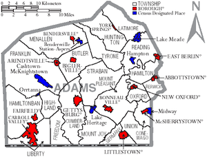
Under Pennsylvania law, there are four types of incorporated municipalities: cities, boroughs, townships, and, in at most two cases, towns. The following boroughs and townships are located in Adams County, as well as unincorporated areas and CDPs:
Boroughs[]
- Abbottstown
- Arendtsville
- Bendersville
- Biglerville
- Bonneauville
- Carroll Valley
- East Berlin
- Fairfield
- Gettysburg (county seat)
- Littlestown
- McSherrystown
- New Oxford
- York Springs
Townships[]
Census-designated places[]
Census-designated places are geographical areas designated by the U.S. Census Bureau for the purposes of compiling demographic data, but are not actual jurisdictions under Pennsylvania law. Other unincorporated communities, such as villages, may be listed here as well.
Unincorporated areas[]
- Barlow
- Beechersville
- Bermudian
- Bittinger
- Bridgeport
- Cross Keys
- Fairplay
- Floradale
- Gargol
- Greenmount
- Guldens
- Iron Springs
- Knoxlyn
- Maria Furnace
- Mount Pleasant
- Mount Tabor
- Peach Glen
- Two Taverns
- Virginia Mills
- Wenksville
Population ranking[]
The population ranking of the following table is based on the 2010 census of Adams County.[25]
† county seat
| Rank | City/Town/etc. | Population (2010 Census) | Municipal type | Incorporated |
|---|---|---|---|---|
| 1 | † Gettysburg | 7,620 | Borough | 1806 |
| 2 | Littlestown | 4,434 | Borough | 1864 |
| 3 | Carroll Valley | 3,876 | Borough | 1974 |
| 4 | McSherrystown | 3,038 | Borough | 1882 |
| 5 | Lake Meade | 2,563 | CDP | |
| 6 | Midway | 2,125 | CDP | |
| 7 | Bonneauville | 1,800 | Borough | 1961 |
| 8 | New Oxford | 1,783 | Borough | 1874 |
| 9 | East Berlin | 1,521 | Borough | 1879 |
| 10 | Lake Heritage | 1,333 | CDP | |
| 11 | Biglerville | 1,200 | Borough | 1903 |
| 12 | Abbottstown | 1,011 | Borough | 1835 |
| 13 | Arendtsville | 952 | Borough | 1896 |
| 14 | York Springs | 833 | Borough | 1868 |
| 15 | Heidlersburg | 707 | CDP | |
| 16 | Bendersville | 641 | Borough | 1866 |
| 17 | Hampton | 632 | CDP | |
| 18 | Hunterstown | 547 | CDP | |
| 19 | Fairfield | 507 | Borough | 1896 |
| 20 | Cashtown | 459 | CDP | |
| 21 | Aspers | 350 | CDP | |
| 22 | McKnightstown | 226 | CDP | |
| 23 | Idaville | 177 | CDP | |
| 24 | Orrtanna | 173 | CDP | |
| 25 | Gardners | 150 | CDP | |
| 26 | Table Rock | 62 | CDP | |
| 27 | Floradale | 38 | CDP |
Notable people[]
- Joel Funk Asper, born in Adams County, United States Congressman from Missouri[34]
- Henry Roelif Brinkerhoff (1787–1844), born in Adams County, United States Congressman[34]
- Dwight D. Eisenhower and Mamie Eisenhower; their retirement home outside Gettysburg is preserved as Eisenhower National Historic Site.
- Erik Harris, football player
- Alpha Jefferson Kynett, (1829–1899), born in Adams County, noted Methodist clergyman and leader of the temperance movement.[34]
- Eddie Plank (1875–1926), Major League Baseball pitcher; third winningest left-handed pitcher of all time. Baseball Hall of Fame induction 1946.
- John Studebaker (1833–1917); co-founder of what would become the Studebaker Corporation automobile company. He was the third son of the founding Studebaker family and was company president from 1868–1917.
- David Day (1854–1897), American Lutheran missionary to Liberia.
- John A. Hauser (1907-1983); president of the apple processing company, C. H. Musselman Company.
See also[]
- Adams County Courthouse (Pennsylvania)
- National Register of Historic Places listings in Adams County, Pennsylvania
References[]
- ^ "PHMC Historical Markers Search" (Searchable database). Pennsylvania Historical and Museum Commission. Commonwealth of Pennsylvania. Retrieved January 25, 2014.
- ^ Jump up to: a b "State & County QuickFacts". United States Census Bureau. Archived from the original on June 6, 2011. Retrieved November 16, 2013.
- ^ "Find a County". National Association of Counties. Archived from the original on May 31, 2011. Retrieved June 7, 2011.
- ^ "2010 Census Gazetteer Files". United States Census Bureau. August 22, 2012. Retrieved March 4, 2015.
- ^ "Gettysburg, PA Monthly Weather". The Weather Channel.
- ^ http://www.adamscounty.us/Dept/Pages/default.aspx
- ^ "2016 Election Results" (PDF).
- ^ Sullivan, Robert David; ‘How the Red and Blue Map Evolved Over the Past Century’; America Magazine in The National Catholic Review; June 29, 2016
- ^ https://uselectionatlas.org/RESULTS/
- ^ "Dave Leip's Atlas of U.S. Presidential Elections". uselectionatlas.org.
- ^ "Our Campaigns - U.S. President". Retrieved January 22, 2021.
- ^ http://www.pacourts.us/assets/files/setting-6015/file-6740.pdf?cb=b74d61
- ^ https://www.dos.pa.gov/VotingElections/OtherServicesEvents/VotingElectionStatistics/Pages/VotingElectionStatistics.aspx
- ^ "Population and Housing Unit Estimates". Retrieved October 12, 2018.
- ^ "U.S. Decennial Census". United States Census Bureau. Retrieved March 4, 2015.
- ^ "Historical Census Browser". University of Virginia Library. Retrieved March 4, 2015.
- ^ Forstall, Richard L., ed. (March 27, 1995). "Population of Counties by Decennial Census: 1900 to 1990". United States Census Bureau. Retrieved March 4, 2015.
- ^ "Census 2000 PHC-T-4. Ranking Tables for Counties: 1990 and 2000" (PDF). United States Census Bureau. April 2, 2001. Retrieved March 4, 2015.
- ^ "U.S. Census website". United States Census Bureau. Retrieved January 31, 2008.
- ^ Pennsylvania Department of Health, Birth Age County Reports 1990 and 2011, 2011
- ^ Robert Wood Johnson Foundation (2016). "Pennsylvania Teen Births 2013".
- ^ US Census Bureau (2015). "Poverty Rates by County Small Area Income and Poverty Estimates".
- ^ Pennsylvania Budget and Policy Center (2012). "Student Poverty Concentration 2012". Archived from the original on December 22, 2015. Retrieved December 12, 2015.
- ^ "Office of Management and Budget". The White House.
- ^ Jump up to: a b "2010 Census Population Map". Archived from the original on August 5, 2014.
- ^ Pittsburgh Business Times, Statewide School Academic ranking, April 4, 2016
- ^ Pittsburgh Business Times (April 6, 2012). "Statewide School District Rankings". Archived from the original on October 23, 2012.
- ^ Pittsburgh Business Times (April 10, 2015). "Guide to Pennsylvania Schools Statewide School District Ranking 2015".
- ^ Pennsylvania Department of Education (2015). "Pennsylvania Charter School".
- ^ Lincoln Intermediate Unit 12 website (accessed April 2010)
- ^ "Home — Adams County Historical Society". www.achs-pa.org.
- ^ Jump up to: a b c d e f "Home - Adams County Library". www.adamslibrary.org.
- ^ "East Berlin Community Library". October 19, 2011. Archived from the original on October 19, 2011.
- ^ Jump up to: a b c Who Was Who in America, Historical Volume, 1607–1896. Chicago IL: Marquis Who's Who. 1963.
External links[]
| Wikimedia Commons has media related to Adams County, Pennsylvania. |
| Wikivoyage has a travel guide for Adams County (Pennsylvania). |
- Official website
- Adams County Community Foundation
- Adams County Visitor Information
- Gettysburg Photographs.com
| show Places adjacent to Adams County, Pennsylvania |
|---|
| show Municipalities and communities of Adams County, Pennsylvania, United States |
|---|


| show Authority control |
|---|
- Pennsylvania counties
- Adams County, Pennsylvania
- 1800 establishments in Pennsylvania
- Populated places established in 1800