Enterline, Pennsylvania
Enterline, Pennsylvania
Enderlein | |
|---|---|
Unincorporated community | |
 Enterline, Pennsylvania | |
| Coordinates: 40°27′47″N 76°50′31″W / 40.463°N 76.842°WCoordinates: 40°27′47″N 76°50′31″W / 40.463°N 76.842°W | |
| Country | United States |
| State | Pennsylvania |
| County | Dauphin |
| Elevation | 659 ft (201 m) |
| Time zone | UTC-5 (Eastern (EST)) |
| • Summer (DST) | UTC-4 (EDT) |
| Area code(s) | 717 |
| GNIS feature ID | 1174282[1] |
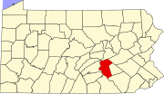
Enterline (Pennsylvania German: Enderlein) is an unincorporated community in Wayne Township, Dauphin County, Pennsylvania, in the Harrisburg-Carlisle Metropolitan Statistical Area.[1][2] The latitude is 40.463, and the longitude -76.842; its elevation is 659 feet (201 m).
History[]
Enterline was named for a family of settlers, originally spelled "Enderlein", as is the current Pennsylvania German name.[3]
References[]
- ^ a b "Enterline, Pennsylvania". Geographic Names Information System. United States Geological Survey.
- ^ Pennsylvania Department of Transportation-Wayne Township, Dauphin County, Pennsylvania
- ^ Notes and Queries, Historical, Biographical and Genealogical, Relating Chiefly to Interior Pennsylvania. Harrisburg Publishing Company. 1895. p. 21.
External links[]
Categories:
- Harrisburg–Carlisle metropolitan statistical area
- Unincorporated communities in Dauphin County, Pennsylvania
- Unincorporated communities in Pennsylvania

